
by Terri Cook Thursday, March 1, 2018
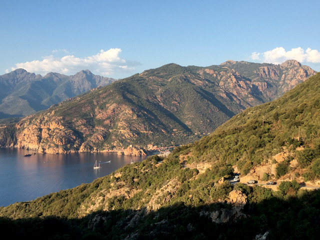
The sun's last rays bathe the west coast of Corsica, whose spectacular geology and easygoing culture are a fusion of Italian, French and other Mediterranean influences. Credit: Terri Cook and Lon Abbott.
Last summer, after trekking for a month with my son across the cool and rainy Alps, I found myself craving warm sunshine and long, sandy beaches. So we headed to Corsica, the Mediterranean’s most mountainous isle, whose narrow shoreline is dotted with gorgeous strips of white sand beaches. Best known as the birthplace of Napoleon Bonaparte, the island has a long history of Italian rule followed by nearly 250 years of French control, which it remains under today. The resulting culture combines the best attributes of both countries. The island’s rugged topography is also a blend, the consequence of rocks of very different ages and origins being thrust together during one of Earth’s great tectonic upheavals. Together, these fusions have created an irresistible mixture of stunning scenery, beautiful beaches, captivating cultural attractions and mouthwatering cuisine that is distinctly Corsican.
Owing to Corsica’s strategic location in the heart of the western Mediterranean Sea, this 8,600-square-kilometer island has suffered a long history of foreign invasions, including by the Phoenicians, the ancient Greeks, the Carthaginians, and later, the Romans, who exploited its copper deposits and prolific fishing grounds. Following the empire’s decline, the Italian city-state of Pisa dominated the isle during most of the Middle Ages before losing hegemony to Genoa, its fierce seafaring rival, at the start of the Renaissance.
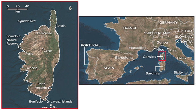
Corsica, an island off the coasts of France and Italy, is part of France. Visitors can fly or take a ferry to get to the island but will need a car to get around. Credit: both: K. Cantner, AGI.
“Except for a few short-lived incursions, the Genoese retained control until the mid-18th century, when the Corsicans, under the leadership of national hero Pascal Paoli, declared their independence and established the Corsican Republic. After failing to oust Paoli, the Genoese secretly sold the island to the French, who crushed Paoli’s uprising in 1769 and have, despite strong local support for Corsican independence, controlled the isle ever since. This nationalism peaked during the 1960s, when some armed confrontations occurred.
The situation has since settled down, and in 2003, voters narrowly defeated a referendum to grant the local assembly more sovereignty, although many Corsicans remain committed to gaining more autonomy from France. As you drive around the island, it’s common to see “Corsica Libera” signs and graffiti, especially in the craggy interior, the traditional nationalistic stronghold.
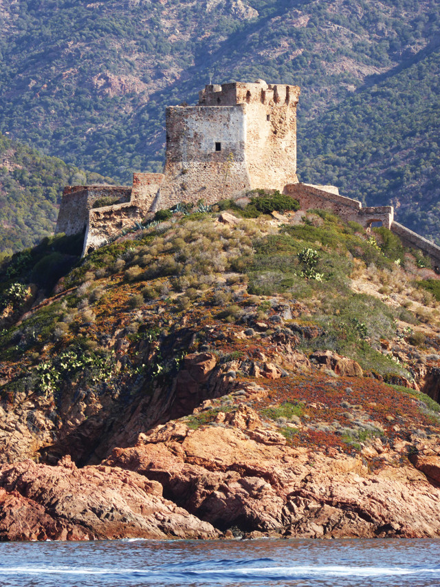
The watchtower above Girolata, a small fishing village in the Scandola Nature Reserve, is part of an extensive system of 16th-century Genoese fortifications that ring the island. Credit: Terri Cook and Lon Abbott.
<” class=““caption”>Corsica’s landscape is also the result of diverse influences that reflect its position at a major crossroads. The island’s geologic story begins with the assembly of Pangea, Earth’s most recent supercontinent, during which Africa slammed into a united North American-northern European landmass in a massive collision called either the Variscan or the Hercynian Orogeny, depending on whom you ask. This collision, which occurred during the Devonian and Carboniferous periods, formed a belt of mountains stretching more than 3,000 kilometers across Western Europe. The extreme tectonic forces produced a series of high-grade metamorphic rocks that were soon intruded by magma, creating nearly contemporaneous granite. Today, these Variscan rocks form the core of “Crystalline Corsica,” the geologic province that comprises the island’s western and southern reaches.
“Alpine Corsica,” the island’s second major geologic province, consists of a stack of Mesozoic schists and other metamorphic rocks found on the northeastern third of the isle. These were metamorphosed much later, while Pangea was slowly breaking apart. Subduction of the ancient Tethys Sea beneath Europe gradually shifted Africa farther north until the two continents met in a series of messy collisions. During one of these, a fragment of Africa (the Adriatic Microplate) slammed into Europe, plastering a stack of highly deformed rocks, including slivers of oceanic crust and sediments deposited on the floor of the Tethys Sea, atop the Variscan basement, and forming the Western Alps in the process.
More recent extension, the details of which geologists are still debating, later ripped modern-day Corsica’s rocks from the Provence portion of mainland France and opened the Ligurian Sea in between. Since this extension began about 25 million years ago, the Corsardinian Microplate has rotated about 45 degrees to the southeast, creating a (geologically) independent fragment of continental crust.
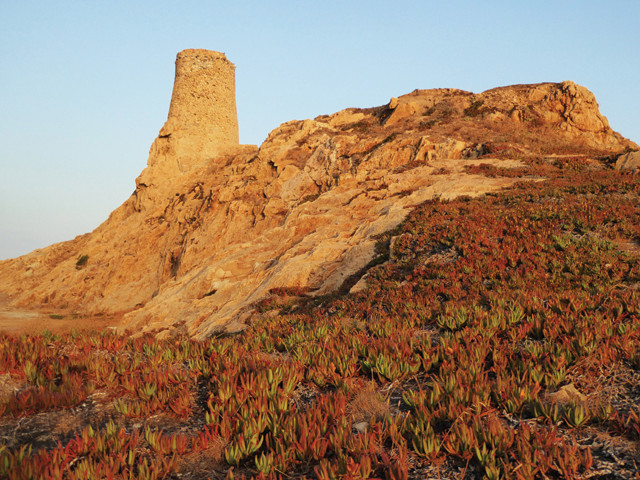
Red Island, the namesake for the northern port town L'Ile Rousse, is crowned by another 16th-century Genoese watchtower. Credit: Terri Cook and Lon Abbott.
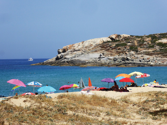
Bodri Beach, one of many white-sand strips near L'Ile Rousse, can be easily accessed via a tramway. Credit: Terri Cook and Lon Abbott.
“A great place to begin your exploration of Corsica is L’Ile Rousse, a northern port town founded by Pascal Paoli in 1758 to rival the nearby Genoese settlement of Calvi. Like most of Corsica’s bustling beach towns, L’Ile Rousse is located in a spectacular setting on a narrow coastal strip nestled between a long, white-sand beach and the steep interior mountains. The town, whose name translates to Red Island, is named for a red rocky islet that forms the natural harbor’s western edge. Locally called Ile de la Pietra — the Island of Stone — the islet is crowned by a small 16th-century Genoese watchtower and a lighthouse built in 1857. Because it’s linked to the mainland by a causeway, the Red Island is a popular place to walk at sunrise and sunset and enjoy the far-reaching views.
“Near the start of the causeway, my son and I rented a kayak from the local nautical club and spent an enjoyable couple of hours paddling around the islet while pausing for refreshing dips in the cool, turquoise-blue sea. Like the rest of western and southern Corsica, the Red Island’s pinkish granites are Variscan in age.
“L’Ile Rousse is also a great place for lazing away hours — or days — on the beach. In addition to the town’s 3-kilometer-long sandy strip, which tends to be crowded, many more beaches line the coast in both directions. Those to the west are most easily accessed via the charmingly antiquated Tramway de la Balagne, a clanking train that rattles along the north coast several times per day.
“After the sun sets, locals and visitors alike emerge from the shade to socialize in the historic Old Town, which is centered on Place Paoli, L’Ile Rousse’s tree-lined square. It’s easy and fun to get lost in the narrow alleyways, which in the evening are filled with outdoor seating for the town’s numerous restaurants, cafes and bars. You can while away many more pleasant hours sipping glasses of Patrimonio, one of the robust local red wines, while watching the locals playing bocce and dining on freshly-baked, thin-crust margherita pizza — my son’s preferred meal — or my favorite, a large green salad topped with grilled brocciu, a tasty goat-milk cheese.
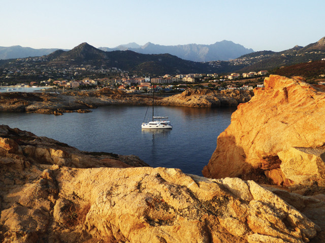
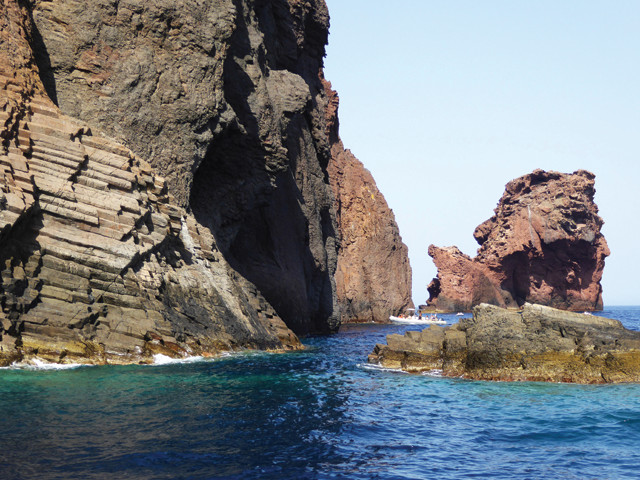
“One of the highlights of Corsica’s west coast is Porto, a tiny town tucked inside the stunning Gulf of Porto. The gulf’s southern shore is ringed by Les Calanques, a dramatic series of granite cliffs that plunge several hundred meters into the deep-blue sea, whereas the northern side hosts a craggy coastline dotted with sea stacks, grottos and barren islets that collectively compose the Scandola Nature Reserve, a UNESCO World Heritage site.
Like most of Corsica's beach towns, L'Ile Rousse is perched on a narrow coastal band between the steep interior mountains and the deep-blue sea. Credit: Terri Cook and Lon Abbott.
“Because there is almost no flat land, the town sprawls along the length of a steep, forested valley leading to the sea. Most of the tourist facilities are located close to the coast, where the river has deposited enough sand to form a small beach that’s linked by a footbridge to the harbor and the rest of town. The easiest and most enjoyable way to explore this spectacular scenery is by taking one or more of the boat trips that regularly depart from the small port. We took an early morning trip to see the reserve, where peregrines and bearded vultures circled high above white-capped waves crashing into the rocky coast. While many of the reserve’s rocks are Variscan granites, there are also light-colored rhyolites and patches of darker basalt erupted from younger volcanoes associated with the opening of the Ligurian Sea. The resulting range of colors and textures, including spectacular hexagonal columns and explosive volcanic breccias, augments the memorable scene.
We also took an evening boat ride along the gulf’s equally scenic southern coast to photograph the sun’s last rays bathing the rosy granite cliffs. During our second evening in Porto, we climbed up the rocky promontory on the town’s southern edge to visit another Genoese tower, one of dozens of ancient fortifications built around the island to warn of possible intruders. After watching the blazing sun slowly dip into the western Mediterranean, we savored freshly grilled seafood followed by a plate of local cheese.
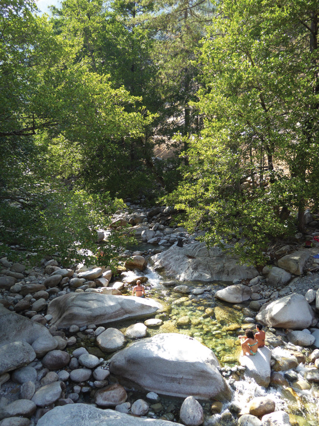
On hot summer afternoons, Corsicans flock to the beautiful Restonica Valley to enjoy the shady creek. Credit: Terri Cook and Lon Abbott.
“After several days relaxing on the coast, we followed one of the narrow, twisting roads toward Corte, the largest town in the island’s mountainous center and the capital of Paoli’s short-lived Corsican Republic. The town is dominated by a striking citadel whose highest structure, the Eagle’s Nest, was built in the early 1400s. Although the fortress is not well-preserved, it’s worth walking up to the top to see the spectacular views of mountain range after mountain range stretching to the horizon.
Corte is located near the shear zone that separates Crystalline from Alpine Corsica, so instead of being built atop the pink granite that characterizes so much of the island, the citadel is perched on greenish, deformed rocks — some of the island’s younger metamorphic units that were shoved atop the Variscan basement during the Alpine Orogeny. This hybrid geologic foundation for Paoli’s capital seems an appropriate tribute to the fusion of cultures that defines modern Corsica.
The Scandola Nature Reserve's volcanic rocks, including these striking hexagonal columns, date to the opening of the Ligurian Sea and the extension that separated Corsica and Sardinia from mainland Europe. Credit: Terri Cook and Lon Abbott.
“In addition to strolling through Place Paoli, Corte’s central square, which hosts a large statue of the national hero, we drove up the nearby Restonica Valley, where a beautiful stream winds through a deep granite gorge carved into some of the island’s highest-elevation terrain. Dozens of trails climb the valley’s steep, forested walls, including one that accesses the G20, a challenging, 180-kilometer-long hiking route that crosses the entire island. On hot summer afternoons, hundreds of Corsicans flock to this valley to enjoy picnics along the cool and shady creek.
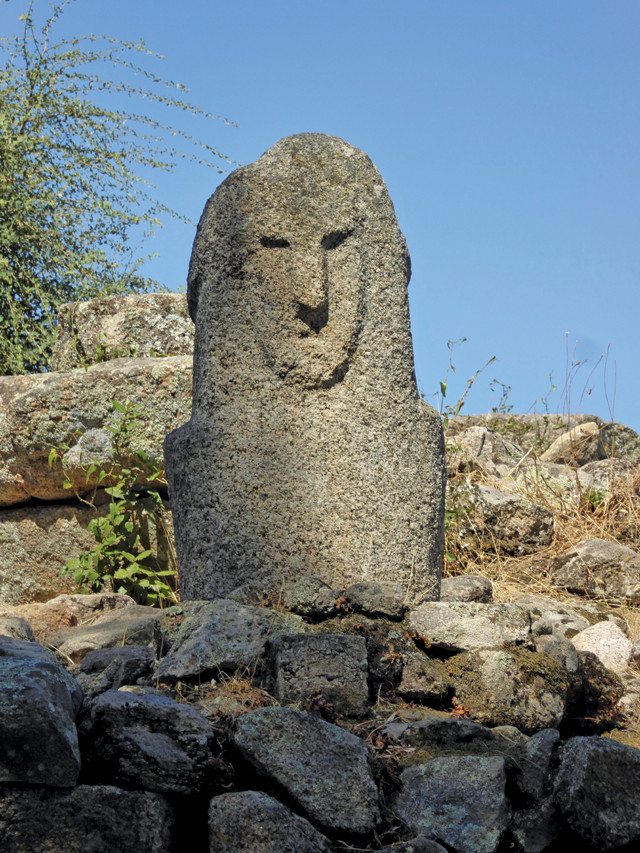
Filitosa, Corsica's most important prehistoric site, protects a large collection of carved Bronze Age standing stones. Credit: Terri Cook and Lon Abbott.
Our favorite part of Corsica was the lively port of Bonifacio on the island’s southwestern tip. Just a short ferry ride from Sardinia, the town surrounds an incredible natural harbor overlooked by a huge, walled citadel still accessed via drawbridge. The great location, gorgeous scenery, and dozens of high-end shops and restaurants lining the water draw yachties from around the world, including some with mega-luxury yachts that barely seem capable of squeezing between the hundreds of other boats.
“One reason that Bonifacio is so distinctive is the harbor’s steep, white cliffs, which are unlike anything else we saw in Corsica. The town is built atop a narrow peninsula of white limestone deposited when sea level briefly rose about 20 million years ago as the Corsardinian Microplate separated from the rest of Europe. Just east of the port’s mouth is a steep staircase whose 187 steps were, according to legend, carved into the white cliff during a single night by invading Aragonese troops who, upon reaching the top, were quickly defeated.
© 2008-2021. All rights reserved. Any copying, redistribution or retransmission of any of the contents of this service without the expressed written permission of the American Geosciences Institute is expressly prohibited. Click here for all copyright requests.