
by Terri Cook and Lon Abbott Monday, September 18, 2017
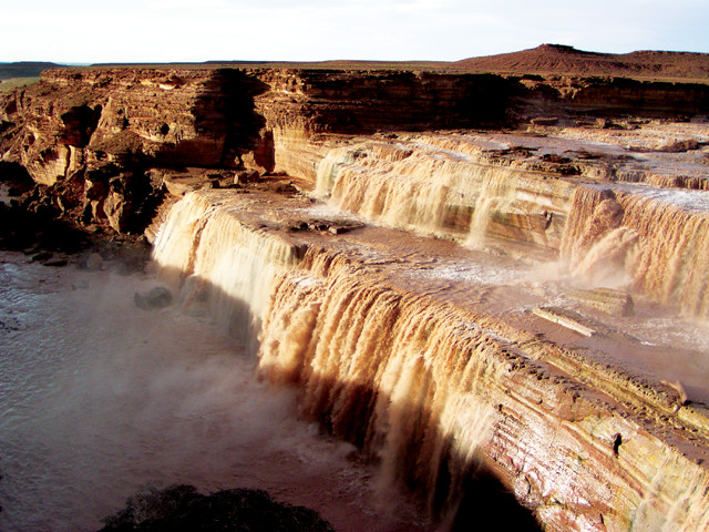
Although better known for its parched deserts and graceful saguaros, Arizona also hosts a wide variety of spectacular volcanic features, including Grand Falls. This waterfall, which only flows at certain times of the year when snows melt or monsoon rains fall, was created when a lava flow from Merriam Crater blocked the channel of the Little Colorado River. Credit: Terri Cook and Lon Abbott.
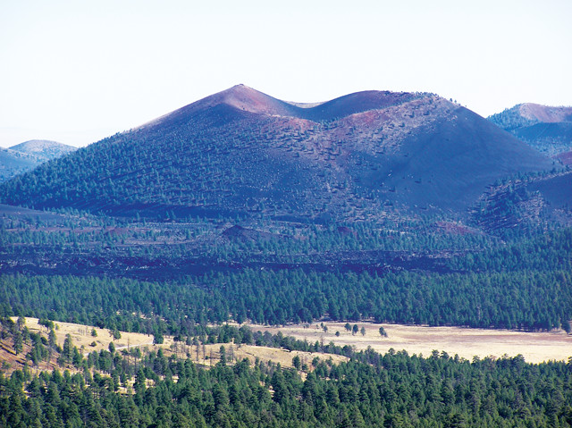
When it comes to U.S. volcanoes, most people think of Hawaii, Alaska, or Mount St. Helens and Mount Rainier in the Pacific Northwest. Ask them about Arizona, and images of the Grand Canyon, red rock deserts and saguaros baking in the sun probably come to mind. But Arizona also hosts an impressive volcanic field. Near the outdoorsy college town of Flagstaff in northern Arizona, more than 600 mounds and mountains — every one of them a volcano in the San Francisco Volcanic Field — are sprinkled across the high plateau on which the town is perched. Few places in the country exhibit so many types of volcanic features, including jagged lava flows, crumbly cinder cones and the remnants of a towering stratovolcano, in such a compact region. This great diversity led NASA to select the area as a training ground for the Apollo astronauts in the 1960s and ‘70s. But Flagstaff’s cones and craters, and the region’s spectacular scenery, also offer non-astronauts an out-of-this-world experience.
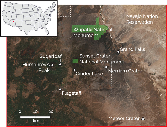
Many neat geologic sites are located close to Flagstaff. Credit: both: K. Cantner, AGI.
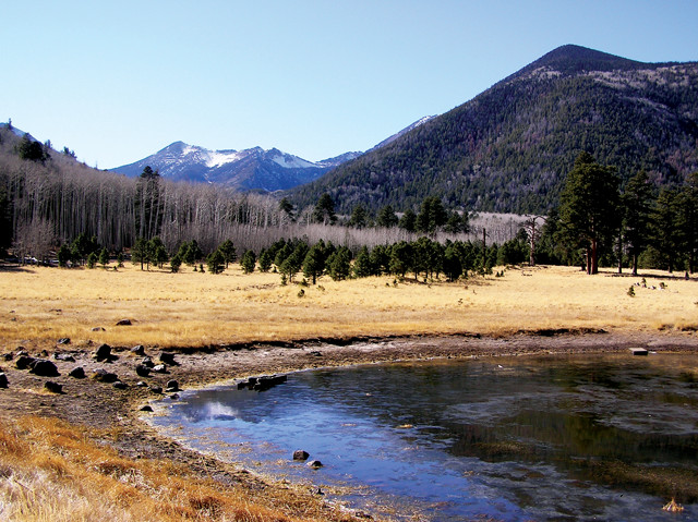
Located on the southwestern edge of the Colorado Plateau, Flagstaff sits at nearly 2,100 meters elevation. Approaching the town of 70,000 from any direction entails a gradual climb of at least 1,000 meters, from parched plains and pinyon-juniper forest to Flagstaff’s tranquil, ponderosa pine-studded volcanoes. Although none of the volcanoes that currently exist are expected to erupt again, the field is still considered active.
Unlike most volcanic fields, the San Francisco field lies far from any tectonic plate boundary. It is one of several volcanic fields that perch on the very edge of the Colorado Plateau, next to the actively stretching Basin and Range Province. After a long-lived subduction zone off the West Coast shut down about 30 million years ago, the stress field in the American Southwest became extensional, triggering thinning of the crust from Southern California to Arizona to form the Basin and Range. This process brought warm mantle rock toward the surface, and the consequent heating and depressurization of this rock led to volcanism around what’s now Flagstaff, starting about 8 million years ago.
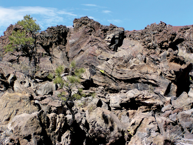
The diverse volcanic features on display here stem from the variety of magmas that have erupted. Volcanic rocks are classified by their silica composition, for which color serves as a loose guide. Basalt, the lava type richest in iron and magnesium and most deficient in silica, is black. Most of the San Francisco Volcanic Field’s volcanoes consist of basalt. Andesite, which forms the region’s largest volcano, is dark gray in color thanks to its intermediate silica content. Finally, rhyolite, the most silica-rich lava, is light gray. Sugarloaf, a small dome that sits at the feet of the San Francisco Peaks, consists of rhyolite.
The silica content of magma controls its viscosity, which is the most important factor in determining a volcano’s style of eruption, and hence its size and shape. Basalt is relatively runny, so basalt lava flows can travel tens of kilometers across the landscape, slowly releasing pent-up gases, a process that leaves behind empty, spherical holes called vesicles in the lava. Because of its low viscosity, basalt eruptions tend to be relatively tame compared to other types. Stickier, higher-silica magmas — like those in stratovolcanoes such as Washington’s Mount Rainier — trap gases more tightly, leading to buildups of pressure and more explosive eruptions.
The reason why so many different types of magma erupted in the San Francisco Volcanic Field lies in a process called partial melting. As rock heats up, it doesn’t usually melt completely, or all at once. Instead, minerals with higher silica contents, which have lower melting points, melt first, resulting in a “partial melt” that contains a higher proportion of silica than the parent material. Because this melt is less dense than the surrounding solid rock, it gradually rises toward Earth’s surface.
Partial melting of the upper mantle, which contains a very low proportion of silica, results in basalt, the material that makes up most of Flagstaff’s volcanoes. As the basalt magma rises, its heat can partially melt the continental crust through which it passes. And because continental crust contains more silica than upper mantle rock or basalt, the resulting partial melts form subsidiary magma chambers that are even richer in silica, producing lighter volcanic rocks like andesite and rhyolite.
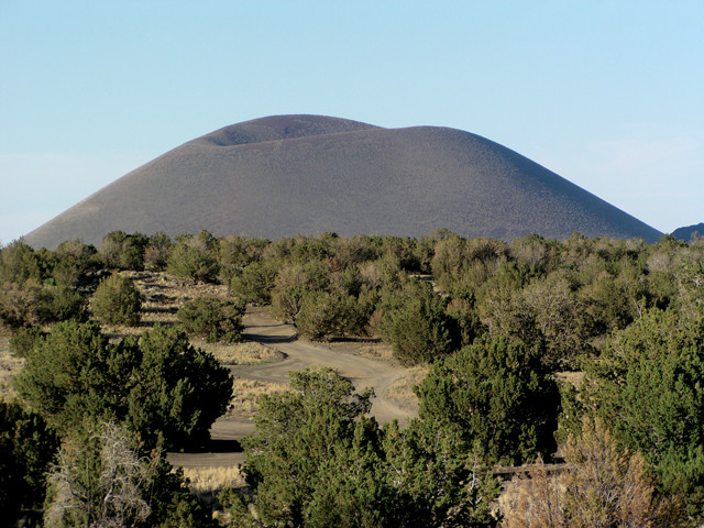
Hundreds of cinder cones pierce the high plateau on which the lively college town of Flagstaff sits. Credit: Terri Cook and Lon Abbott.
Flagstaff’s largest volcano, which lends its name to the entire field, is a horseshoe-shaped massif crowned with five summits collectively known as the San Francisco Peaks. The tallest of the five summits, 3,850-meter-high Humphrey’s Peak, is the highest point in Arizona and is a popular hiking and skiing destination.
To the Navajo, whose reservation is less than an hour’s drive north of Flagstaff, the massif is one of four sacred mountains that mark the boundaries of their traditional lands as well as the cardinal directions. The San Francisco Peaks represent the Sacred Mountain of the West — the direction of the sunset and hence the accomplishment of each day’s plans, which cumulatively correspond to a person’s life.
This symbolism is the peaks are built from layer upon layer of alternating andesitic volcanic ash and lava flows that erupted between about 1.8 million and 400,000 years ago. This layering — and its andesite composition — identifies the peaks as remnants of a stratovolcano that, according to geological reconstructions, once soared to heights of 4,500 to 4,800 meters prior to the major landslide that formed today’s horseshoe. The horseshoe encircles a central valley called the Inner Basin, where snowmelt percolates through the porous volcanic rocks to form one of Flagstaff’s most important sources of water.
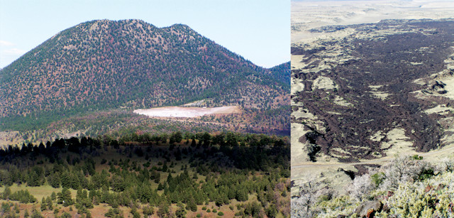
Northern Arizona hosts an unusual diversity of magmas, which vary from dark basalt, as seen in one of the volcanic field's many lava flows (left), to the light-colored, silica-rich rhyolite observed in the volcanic dome known as Sugarloaf (top). Credit: both: Terri Cook and Lon Abbott.
Today, Sugarloaf, a 300-meter-high, loaf-shaped dome of rhyolite, blocks the Inner Basin’s mouth. Because rhyolite is highly viscous and resists flow, such lava domes typically do not spread out and flatten, but instead grow by inflation: As more lava rises toward the surface, the dome expands like an inflating balloon. But because the rocky margins around the dome are rigid — and not made of stretchy rubber — it shatters rather than stretches as it cools, gradually wrapping the dome in a distinctive cloak of angular, broken rock called breccia. Given its position, Sugarloaf, which erupted 200,000 years ago, must have formed after the landslide occurred, meaning the landslide happened between 400,000 and 200,000 years ago.
Through the cleft in the landscape left by this landslide, visitors can access the Inner Basin during the summer and fall via a scenic dirt road. Within the basin are beautiful, alpine-like terrain and hiking trails through stands of aspen trees that make for colorful, leaf-peeping experiences in the fall and defy stereotypes of Arizona scenery.
Most of the San Francisco Volcanic Field’s volcanoes are basaltic cinder cones. Just 17 kilometers east of the San Francisco Peaks stands Sunset Crater, a cinder cone that erupted just over 950 years ago, making it the field’s youngest volcano and the featured attraction in its namesake national monument. Although visitors aren’t allowed to hike up it, there are great views of its perfect cone shape and oxidized, orange-red rim from the monument’s Lava Flow Trail, which crosses the fresh-looking Bonito lava flow.
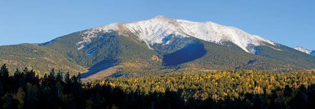
By far the largest volcano in northern Arizona is the massif called the San Francisco Peaks, an extinct stratovolcano that collapsed in a massive landslide between 400,000 and 200,000 years ago. Credit: ©iStockphoto.com/IronmanFireman.
Members of the Sinaguan culture likely witnessed Sunset Crater’s eruption; the visitor center displays molds of Sinaguan corncobs enveloped by lava. From trees living at that time, as well as the beams from Sinaguan pit houses buried by lava, scientists have determined that Sunset Crater erupted in either late A.D. 1064 or early 1065. If it was similar to modern volcanic cone-forming eruptions, the Sunset eruption would have begun with glowing lava fountains spewing bits of liquefied rock that cooled in mid-air. These bits then fell back to the ground as cinders, which piled up around the central volcanic vent to build the 300-meter-high cone.
About a century later, another, less-gaseous eruption seeped from the cone’s northwest side to form the Bonito lava flow, which crumpled and cracked as it cooled. While walking across the flow on the Lava Flow interpretive trail, you can see many vesicles as well as volcanic “bombs” — blobs of ejected molten rock that stretched into elongated shapes while falling back to Earth. The sixth stop on the 1.5 kilometer-long trail marks a lava tube, a conduit that forms as a crust builds up around still-flowing magma. Once an eruption ceases and the magma inside the conduit drains away, all that remains is a hollow tube. Such tubes can stretch for kilometers. Visitors used to be able to tour the lava tube, but it was closed after a roof collapse. It is home to an ice cave in which the temperature remains below freezing year-round; at the lava tube trail stop, visitors can feel the cold air rushing out of the cave.
The San Francisco Peaks' Inner Basin hosts trails that wind through groves of quaking aspen and beautiful alpine terrain. Credit: Terri Cook and Lon Abbott.
Several more volcanoes can be seen along the 55-kilometer scenic drive that loops through both Sunset Crater National Monument and Wupatki National Monument, which protects settlements built by the Sinagua and other Ancestral Puebloan cultures. The most photogenic of these is Wupatki Pueblo, a multistory Sinaguan dwelling with more than 100 rooms built from blocks of red Moenkopi Sandstone and the occasional black basalt. This area didn’t become densely populated until about a century after Sunset Crater erupted, by which time the Ancestral Puebloans had learned that the ash and cinders from the eruption had increased the soils’ ability to hold water. This population surge, however, was brief. By 1225, the pueblo, and much of the surrounding region, was deserted, most likely due to drought.
Sunset Crater, a cinder cone that erupted in A.D. 1064 or 1065, is named for the oxidized "sunset" hues dusting its rim. Credit: Terri Cook and Lon Abbott.
Another magnificent site that defies most people’s image of Arizona scenery is Grand Falls, a Navajo Nation park located on the Little Colorado River, a 110-kilometer drive (the last 15 or so kilometers on a bumpy, potentially four-wheel-drive dirt road) from Flagstaff. Although bone-dry for months at a time, the Little Colorado River’s flow can swell to 5,600 cubic meters per second following snowmelt or monsoon rains. When this much water pours over Grand Falls, it creates a roar and windblown spray worthy of its nickname, the Desert Niagara.
The Bonito lava flow in Sunset Crater National Monument is known for its crumpled surface. Credit: Terri Cook and Lon Abbott.
This spectacle formed about 20,000 years ago when basalt from Merriam Crater, a cinder cone that you pass on the drive in, flowed more than 10 kilometers until it reached the gorge that the Little Colorado had carved in the surrounding, white limestone. The basalt filled this gorge and then flowed down it another 33 kilometers before finally stopping. This enormous plug acted like a dam, diverting the river, which made an end run around the basalt to plummet back into its old channel over a 60-meter-high limestone cliff that had, just a short time before, comprised part of its canyon wall. In a short walk along the rim, you can see a perfect cross section of the ancient limestone channel filled to the brim with black basalt.
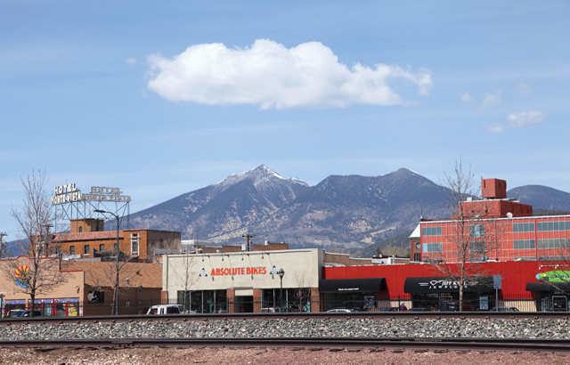
In addition to making a great basecamp from which to view the area’s volcanoes, Flagstaff itself is a fun place to simply hang out. The cool climate offers a welcome respite from the heat of the surrounding lower elevations, and the downtown is filled with a good selection of eateries and brewpubs. It’s also a training center for many Olympic and Olympic-hopeful runners and home to a fabulous natural history museum, the Museum of Northern Arizona. Flagstaff has long been an important transportation hub: In addition to its location on Interstate 40, it’s also along historic Route 66 and a major east-west railroad line. And the town’s visitor center is housed in a 1926 train depot where Amtrak passengers still alight.
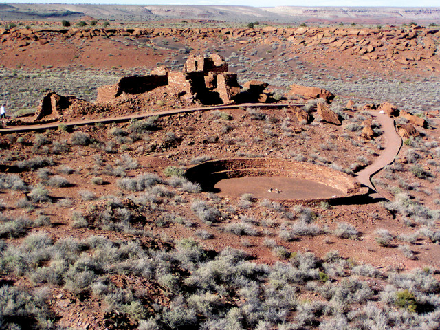
The ruins of Wupatki Pueblo, the centerpiece of Wupatki National Monument, include more than one hundred rooms and a Mesoamerican-style ball court. Credit: Terri Cook and Lon Abbott.
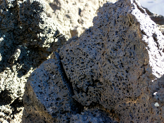
Basalt in the Bonito lava flow is filled with hollow vesicles in which gas bubbles were once trapped. Credit: Terri Cook and Lon Abbott.
The area has also played an important role in America’s space exploration history. You can visit Lowell Observatory, one of our nation’s oldest astronomical observatories and the place where Pluto was discovered. And just 70 kilometers east of town is one of the world’s best examples of an entirely different type of crater: Barringer or Meteor Crater, an impressive 170-meter-deep and 1.6-kilometer-wide hollow gouged by a meteor that struck this spot 50,000 years ago while traveling 42,000 kilometers per hour. The resulting explosion was 200 times more powerful than the atomic bombs dropped on Nagasaki and Hiroshima.
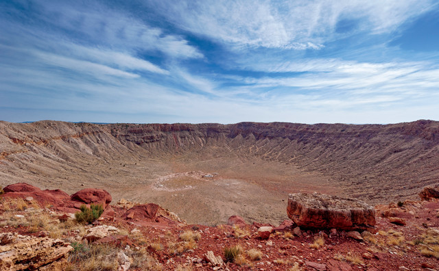
A meteor that struck northeastern Arizona's parched plains about 50,000 years ago created a very different type of crater. Credit: ©iStockphoto.com/Neutronman.
A 635-kilogram chunk of the iron meteorite that caused this damage is on display in the Meteor Crater Museum, which also houses an exhibit about the Apollo space program, whose astronauts trained on the crater floor between 1963 and 1970. Planetary geologist Gene Shoemaker’s studies of Meteor Crater laid to rest a long-standing controversy about its origin and were instrumental in NASA’s and the U.S. Geological Survey’s decision to establish the Astrogeology Science Center in Flagstaff. In 1963, program scientists blasted hundreds of craters at Cinder Lake, a volcanic site northeast of Flagstaff, to reproduce a portion of the moon’s Sea of Tranquility. NASA used this “moonscape” to train the astronauts and to test crucial equipment, including the lunar rovers.
Flagstaff is surrounded by volcanoes. Credit: ©iStockphoto.com/DenisTangneyJr.
There’s no doubt that a trip to Arizona to see its iconic canyon and cacti should be high on anyone’s travel list. But while you’re there, reserve a couple of days to also tour its cones and craters. You’ll be amply rewarded with magnificent geology that will expand your notion of Arizona’s diverse landscapes.
© 2008-2021. All rights reserved. Any copying, redistribution or retransmission of any of the contents of this service without the expressed written permission of the American Geosciences Institute is expressly prohibited. Click here for all copyright requests.