
by John Van Hoesen Tuesday, June 5, 2018
Credit: AGI/NASA
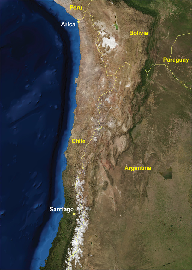
Mention the Atacama Desert and many people likely imagine an ocean of sand where rain never falls and life faces insurmountably hostile conditions. This is, after all, where scientists go to study Mars. Although some regions of the Atacama are indeed stark and barren, the northern section of this vast desert, which stretches approximately 965 kilometers along the western edge of Chile, contains diverse ecosystems, a rich archaeological history and, of course, intriguing geologic features.
The pervasive aridity of the Atacama occurs because the region is nestled between the north-south trending spines of the modern Andes to the east, and the Coastal Cordillera to the west. At an elevation of 6,900 meters, the Andes act as an orographic barrier to air masses from the east. Air masses from the west are cooled by the frigid Pacific waters carried northward along the coast by the Humboldt Current, preventing any significant precipitation other than occasional fog.
The origin of the Atacama can be traced to the rise of the Andes, which began about 27 million years ago after the breakup of the Nazca and Cocos plates and the subsequent changes in the subduction geometry of the Nazca Plate below the South American Plate. The Tertiary uplift of the Andes also gave rise to the Coastal Cordillera, a cornucopia of metasedimentary rocks derived from foreland basin and accretionary wedge deposits, as well as part of a horst-and-graben complex. The mountains of the Coastal Cordillera terminate in the north at the Morro de Arica, a steep promontory that overlooks the city of Arica.
The Chinchorro Mummies of Arica
As a Fulbright Scholar during the spring of 2011, I was lucky enough to live in Arica, one of the northernmost cities in Chile. Arica is billed as the city of eternal spring and this is no exaggeration; the average annual temperature is 22 degrees Celsius and the city receives less than 1 centimeter of rain per year, making it one of the driest cities on Earth. What little rain it receives arrives as llovizna, or drizzle, from the Humboldt-induced fog that is locally called camanchaca.
The most prominent feature in the city is the “Morro,” a sheer lava cliff face interbedded with Jurassic limestone, sandstone and shale that is an iconic symbol of Chilean nationalism. Each Sunday morning, some of the city’s 180,000 residents hold a parade at the base of the cliff celebrating Chilean victory in the 1883 War of the Pacific between Chile, Peru and Bolivia. The Morro not only hosted the final major battle in the War of the Pacific, but it was also an important cultural monument for the Chinchorro culture.
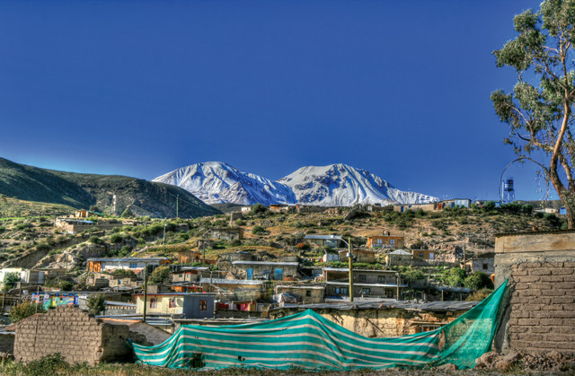
The Nevados de Putre volcanic complex is visible from the town square of Putre. Credit: John Van Hoesen
The Chinchorro provide the earliest evidence of artificial mummification in the world, dating to 3,000 to 5,000 radiocarbon years ago — approximately 2,000 years before the Egyptians. They developed a macabre mortuary system that involved skinning and defleshing their dead, rearticulating the skeleton, covering it with clay and sediment, and then placing the skin back on the bodies. The final touch involved covering the body with a manganese-based paint and wrapping it in reeds prior to burial. There are four styles of Chinchorro mummification — black, red, bandage and mud — and all can be seen at the Archaeological Museum of San Miguel in the Azapa Valley. I also encourage visitors to see the small in situ Chinchorro exhibit near the base of the Morro, at the end of Calle de Colon, and take the time to climb the trail up the Morro to visit the War of the Pacific Museum.
From Arica, one way to see more of the Atacama is to head east on Route 11 toward Parinacota, Chile, just before the border with Bolivia. Route 11 winds through the Lluta Valley, which is drained by the Lluta River and fed by seasonal snowmelt originating in the high Andes. Once you leave the irrigated and manicured sanctuary of Arica, the landscape is reclaimed by various shades of brown, leaving the steep valley walls naked and exposed to the unrelenting force of gravity. Thick sheets of colluvium cover the lower slopes of the valley, providing a foundation for early Incan inhabitants to construct massive geoglyphs depicting llamas, snakes, birds and various anthropomorphic shapes.
Geoglyphs are constructed by piling rocks on top of one another to create a raised impression rather than the typical petroglyph, which is carved or inscribed into a rock. The steep slopes also tempt Candelabra Cactus to take root and endure a life buffeted by strong coastal winds carrying minuscule amounts of water from the camanchaca, while facing the threat of catastrophic slope failure. The Candelabra, with its menacing spiny trunk and seemingly disfigured vertical arms, clearly has adapted to the challenging environment, as it is scattered across the landscape like dandelions in a yard.
The Village of Putre
Traveling east through the valley, the road steadily gains elevation and follows a tortuous path before it reaches the edge of the Altiplano. If you are susceptible to illness from abrupt elevation change or carsickness, you may want to take your time on this section. The last vestige of civilization before entering Lauca National Park is Putre, a small Amaryan village surrounded by Inca-era terracing and nestled in a small quebrada, or valley, fed by snowmelt from the impressive Nevados de Putre volcanic complex visible from the town square. The town has a number of small shops where you can buy a variety of artisanal gifts like llama jerky, ceramics, jewelry, and scarves and mittens made from alpaca hair. It is important to spend at least one night in Putre to acclimate to the altitude before heading any higher into the Andes. The night view of the stars will make your stay well worth the extra time.
From Putre it is a short 10-minute drive to Therma Jurasi, a small but well-developed hot spring area that offers breathtaking views down the valley. The valley walls are stained orange, black and purple from local hydrothermal activity, which produces spring-fed pools of varying temperatures. The road to the hot springs features numerous small herds of both alpacas and guanacos, a camelid related to the alpaca and llama, and a direct view of the hulking mass of Vulcán Taapaca, the centerpiece of the Nevados de Putre range. The most recent volcanism associated with this complex occurred approximately 2,000 years ago, and sediments from that eruption are exposed in the walls of the quebrada just downstream from the village.
Lauca National Park’s Gems
Continue traveling higher into the Andes and you enter Lauca National Park, where the previously cocoa-colored landscape becomes speckled in green due to increased surface water associated with small seasonal wetlands fed by snowmelt. The park was established in 1981 as a UNESCO Biosphere Reserve in response to environmental pressure associated with water resources and mining interests. As if they somehow understand the safety imposed by the park boundary, llamas, alpacas, vicuñas (another relative of the alpaca) and viscachas, relatives of the chinchilla that look like rabbits with a very long tail, begin appearing in greater numbers. However, even the graceful gallop of the vicuña may not hold your interest once you see what can only be called the gem of Lauca — Vulcán Parinacota. Vulcán Parinacota is a giant stratovolcano complex with small glaciers creeping down its picture-perfect conical summit. The magnificent volcano reflects in the stunning waters of Lago Chungará, which is home to the Giant Coot, Andean Duck, Inca Tern, Red-Legged Cormorant and, occasionally, flamingos. The reflection is fitting, as the lake was created when Parinacota erupted approximately 8,000 years ago and changed the local drainage patterns.
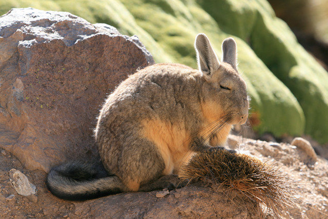
Viscachas are rodents related to the chinchilla. Credit: John Van Hoesen
Guallatiri is the next volcano you’ll see as you head through Lauca toward Salar de Surire Natural Monument. Guallatiri is another massive stratovolcano with active fumarole vents and hot springs flowing from its slopes into nearby rivers. This region of northern Chile offers easy access to stunning volcanoes — including the largest of all the volcanoes in this region, Acotango — surrounded by small lakes teeming with waterfowl and wildlife. In fact, you may even be lucky enough to spot a Darwin Rhea, a flightless bird that looks similar to an ostrich, standing next to a small watering hole.
Salt Flats and Hot Springs
Driving down the circuitous road into the low-lying salt flat of Salar de Surire from the north, the first buildings you pass are associated with a borax mine. Although the majority of the area is protected by the Corporación Nacional Forestal, roughly a third of the salt flat is permitted for mining. Driving past the mining complex itself, you see long rows of bulldozed salt waiting to be processed into household and commercial products like cleaning supplies and food additives. Beyond the mine, the salt flat extends for approximately 20 kilometers to the southeast and shimmers like diamonds glinting in the sun. The white salt is juxtaposed against occasional aquamarine rivulets draining into the dark blue lake all set against the earth-tone backdrop of Vulcán Arintica.
Termas de Polloquere is an undeveloped, steaming hot spring found at the southern end of the salt flat. Small rivers fed by the surrounding mountains drain into the hot spring basin and temper the boiling water upwelling from below. The experience of sitting in one of the highest-elevation hot springs, surrounded by volcanoes and herds of grazing vicuñas, cannot be surpassed — unless, of course, you are treated to the view that I got. Standing less than 100 meters from the shore were two species of magnificent flamingos: the Chilean Flamingo, with its grayish legs, and the James Flamingo, with its red legs and bright yellow bill. Flamingos were the first to mine the salt flats, albeit indirectly — they feed on plankton, which in turn feeds off the minerals present in the salts.
If the fear of a desolate and seemingly never-ending sea of brown has kept you from visiting the Atacama, I highly recommend a trip from Arica to the Lauca UNESCO sites. The ecological and geological diversity of northern Chile — from pelicans and sea lions on the coast to vicuñas and flamingos in the salt flats or the limestone and sandstone of the Morro to the andesitic lava flows of Parinacota — will challenge you to believe you are visiting the Atacama.
© 2008-2021. All rights reserved. Any copying, redistribution or retransmission of any of the contents of this service without the expressed written permission of the American Geosciences Institute is expressly prohibited. Click here for all copyright requests.