
by Zahra Hirji Thursday, January 5, 2012
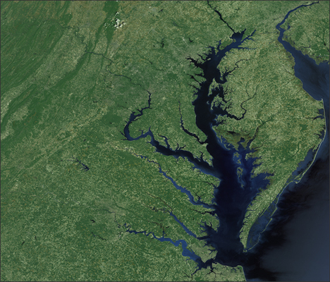
NASA's Landsat satellite mosaic of the Chesapeake Bay. NASA
Sharps Island lighthouse, in Chesapeake Bay, is partially submerged. Skip Willits
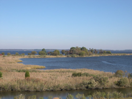
Scenic and fragile, tidal wetlands are a crucial part of the Chesapeake Bay ecology. Copyright January 2006 Jennifer Schmidt.
The lower part of the Chesapeake Bay offers more than crab cakes and boating. Today, the bay is central to one of country’s largest environmental campaigns. But an excursion around the Virginian coasts provides an amazing peek into the mid-Atlantic region’s rich geological, environmental and cultural history, spanning impact events, glaciation, early colonial settlements and modern struggles with pollution and rising sea level.
Cape Charles, a sleepy town located at the mouth of the bay in eastern Virginia, holds the secret to the origins of the Chesapeake Bay region. The town was founded in 1884 as a ferry and railroad community — but buried 400 to 500 meters beneath the town’s streets is an impact crater twice the size of Rhode Island and almost as deep as the Grand Canyon. Either a comet or asteroid struck the then-coastal plain region around 35 million years ago, forming a natural depression 6,400 square kilometers in area and 1.3 kilometers deep, in which water began to pool. This altered landscape later became Chesapeake Bay.
The impact crater was serendipitously discovered in 1983 during a Deep Sea Drilling Project. To learn about the crater discovery as well as the impact process and its resulting effects, visit the Cape Charles Museum, located on the eastern side of the town. (For additional information about discovery and coring of the impact crater, check out a previous article in Geotimes.)
About 18,000 years ago, the last ice age took its turn at wreaking havoc on the mid-Atlantic region. The ice sheets did not quite reach the Chesapeake Bay, extending only as far as Pennsylvania, but the resulting decrease in sea level influenced the region’s geography. At the full extent of the last glaciation, sea level was about 100 meters lower than present levels, exposing the continental shelf along North America. The ancient channel of the Susquehanna River developed in the same region as the current Chesapeake Bay, but extended much farther down the Atlantic coast line.
After the glaciation maxima, the ice sheet started melting and sea levels began rising. By 10,000 years ago the Susquehanna riverbed had formed a narrow estuary, and by 3,000 years ago the Chesapeake Bay had assumed its current shape. Yet, despite all these changes, remnants of the ancient impact event still remain.
Views of the ancient crater rim can be found a relatively short boat ride or drive across the water to the western part of Virginia between Cape Henry and Norfolk. Traces of the crater are etched in the sand layers as well as in the coastal topography: 22-meter-tall scarps mark the western boundary of the rim.
This southern part of Virginia not only provides glimpses of the catastrophic impact event, but also marks the location of America’s earliest colonists. In the early 1500s, Spanish colonists attempted to settle in the region. In 1607, the first British colonists, including explorer John Smith, landed at Cape Henry, dubbed “the First Landing.” Soon after, the colonists established Jamestown, the first permanent English settlement in North America. Visitors to the cape should make sure to stop by the nearby First Landing memorial and spend a day hiking, fishing, and boating at the First Landing Park.
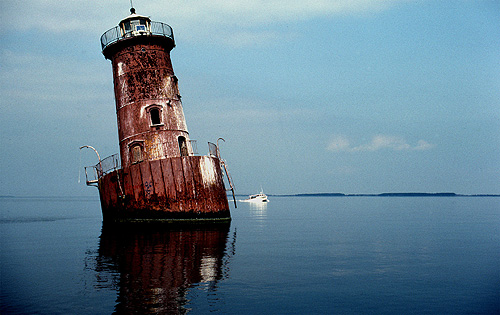
The Chesapeake Bay has changed, and not for the better, since John Smith’s expedition in the early 1600s. Currently the bay is being attacked on two fronts: rising sea levels and increasing pollution. Some Chesapeake islands documented and mapped by John Smith have since been completely flooded. The only remnant of Sharps Island, near the mouth of Choptank estuary, is a lighthouse that is submerged three to four meters deep in water! Other islands north of Cape Charles, such as Tangier and Smith Islands, are still mostly above water, but their wetlands are expanding. Whether the phenomenon of sinking islands and coastline is a result of rising sea level, land subsidence or both is unclear.
The even more serious problem — the increased pollution of the bay — has become so bad that President Obama issued an executive order on May 12, in which he stressed the importance of cleaning up one of our “nation’s treasures.” While a clean-up effort has been in place for 20 to 30 years, officials have repeatedly reported missing targets for reducing nutrient levels (such as potassium and nitrogen levels) and for rebuilding aquatic life populations, as well as an overall leniency by government officials and the general population towards the mission. For a more detailed synopsis of the recent Chesapeake Bay environmental cleanup movement, see the timeline below.
Saving the bay reflects more than an effort to keeping the oyster and crab industries intact and the waters safe. It represents our general attitude toward this national treasure. When visiting the Bay, remember to celebrate not only its delicious seafood and beautiful views, but also its geological and cultural history, from impact crater to colonization.
1983 – EPA completes a report on Chesapeake Bay health. The report
identifies an overabundance of nitrogen and phosphorous, deteriorating
underwater grasses, toxic pollution and over-harvesting of living
resources. The Chesapeake Bay Program is formed between Maryland,
Virginia, Pennsylvania, Washington, D.C., the EPA and the Chesapeake Bay
Commission to attack these problems.
1984 – Maryland passes the Chesapeake Bay Critical Areas Protection
Act to control development along the bay’s shoreline and tidal rivers.
1985 – Maryland bans phosphate detergents. (D.C. erects a similar
ban in 1986, Virginia in 1988 and Pennsylvania in 1990.)
1987 – A new Chesapeake Bay Agreement is written, with the goal to
reduce nitrogen and phosphorous levels by 40 percent by 2000. The
signatories include local government officials from Washington D.C.,
Maryland, Pennsylvania, and Virginia, as well as the EPA and the
Chespaeake Bay Commission.
1996 – The Chesapeake Bay Program sets a goal to reconstruct forest
buffers along the bay’s streams and coastline by 2010. The goals were
met by 2002.
1997 – The Chesapeake Bay Program’s Nutrient Reduction Strategy
Re-evaluation says the 40 percent nutrient reduction goal is in sight.
2000 – An EPA report indicates that the region will not make its
target reductions for phosphorous and nitrogen, with only a 25 percent
reduction in nitrogen and a 13 percent decrease in phosphorous. New
“bolder” goals are drafted, including calling for the Chesapeake Bay to
be taken off EPA’s list of “impaired waters” by 2010. Maryland records
its lowest blue crab harvest in recorded history.
2007 – EPA officially announces that the 2010 goals will not be
met. Nitrogen pollution has been reduced by 30 percent and phosphorus by
22 percent.
2009 – In May, President Obama issued an executive order to clean
up the bay and assigns greater responsibility and power to the EPA.
© 2008-2021. All rights reserved. Any copying, redistribution or retransmission of any of the contents of this service without the expressed written permission of the American Geosciences Institute is expressly prohibited. Click here for all copyright requests.