
by Terri Cook Thursday, April 24, 2014
Credit: Kathleen Cantner, AGI
With its stunningly beautiful landscapes, adrenaline-boosting attractions, renowned wines and craft beers, and easy logistics, New Zealand is one of the world’s foremost tourist destinations. It is especially well known for superb hiking, locally referred to as “tramping” or “bushwalking.” From short strolls through lush temperate rainforest to challenging alpine tracks, New Zealand offers a lifetime’s worth of outstanding walks.
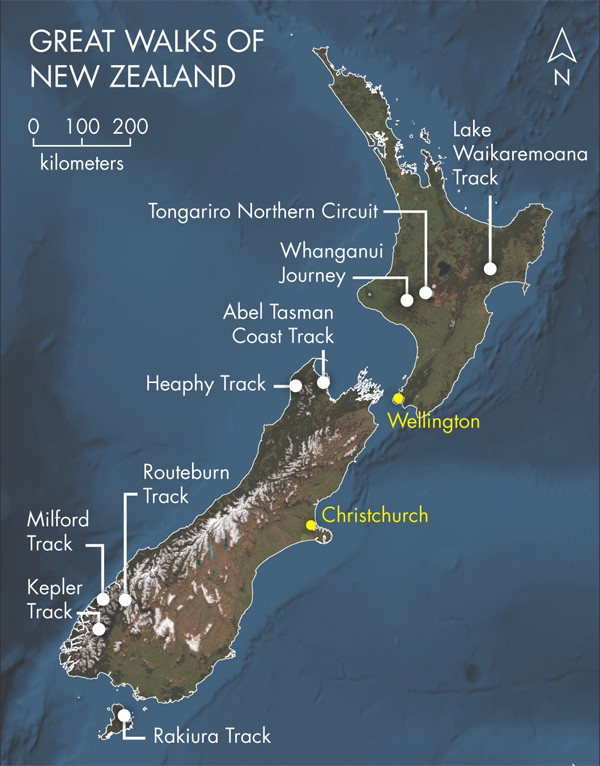
The most famous tramps are the Great Walks — nine of the country’s popular multiday backcountry hikes that highlight some of its most awe-inspiring terrain. When my family headed to New Zealand’s South Island late last year, two of the Great Walks topped our agenda. Regardless of the length or location you choose, lacing up your boots and strapping on a pack is an ideal way to immerse yourself in the scenery, the friendly culture, and the story of the nation’s restless and relentless geology.
When the supercontinent Pangaea began to break apart about 200 million years ago, it first separated into two landmasses, Laurasia to the north and Gondwanaland — which included modern-day Antarctica, Australia and New Zealand — to the south. During Gondwanaland’s subsequent breakup, the now mostly submerged micro-continent of Zealandia, of which New Zealand is a small part, broke away from Antarctica about 85 million years ago. New Zealand has endured noteworthy isolation ever since, resulting in the evolution of unique flora and fauna, including dense temperate rainforest and flightless birds, respectively, which endow the country’s walks with a faintly primeval feeling.
Today, New Zealand is a mountainous country comprising two main islands and covering an area about the size of Colorado. With a population of 4.4 million, however, it hosts a million fewer people than that state, and about 30 million more sheep. Its diverse landscapes are the result of its position straddling the boundary between two major tectonic plates, the Australian and the Pacific. Perhaps it is living life on the edge that gives New Zealanders — who call themselves “Kiwis” in reference to the large native, endangered, flightless birds that inhabit the area — their typically cheerful, fun-loving dispositions.
Three-quarters of the population lives on the North Island, which rests entirely on the Australian Plate and is characterized by volcanic features — including a chain of towering active volcanoes, steaming hot springs and gushing geysers — created by the subduction of the Pacific Plate off the island’s eastern coast. In contrast, most of South Island lies on the Pacific Plate. Here, the plate boundary is defined by a major strike-slip fault, known as the Alpine Fault, with a small component of compression across the boundary that is actively uplifting the breathtaking Southern Alps mountain range. The highest peak is Mount Cook (Aoraki, or “Cloud Piercer,” in the native Maori tongue), a stunning, glacier-capped pyramid that dominates the skyline at 3,754 meters and is accessible only to experienced mountaineers.
In the northeastern corner of South Island, in the vicinity of Nelson Lakes National Park, the plate boundary widens and the faulting changes character from a single strike-slip “backbone” to a series of smaller branching splay faults, which have created a chain of lower, though still impressive, ranges that also host many fine hikes.
All this active tectonism has resulted in a landscape tailor-made for tramping. A great place to begin is at the northwestern tip of South Island. It’s here that the 54-kilometer-long Abel Tasman Coast Track — the country’s most popular trail — winds along secluded beaches tucked into azure bays beneath exposures of sculpted, Cretaceous-aged granite, which is the source of the area’s signature golden sands.
New Zealand has experienced multiple cycles of mountain building, the most recent of which began just 15 million years ago. Abel Tasman’s granite outcrops are part of the Median Batholith, which was emplaced about 105 million years ago during an earlier mountain-building cycle. The root of a volcanic arc, the batholith was created by subduction along the edge of Gondwanaland while New Zealand was still attached.
With rolling climbs, descents of no more than 100 vertical meters and a variety of transportation options, including water taxis and sea kayaks, the Abel Tasman is the easiest and most family-friendly Great Walk. Hikers can opt for one-way trips along its length, which takes about five days to complete, or they can bite off shorter distances. My kids, ages 9 and 12, loved this track. It took about half a day for us to hike between strategically placed huts, which supply drinking water, limited cooking facilities and cozy bunks in shared rooms. We spent each afternoon along the way lounging on the beach before returning to cook dinner and swap stories with other trampers from around the world.
We also hiked the three- to four-day Kepler Track, a much more challenging, and rewarding, experience. The 60-kilometer-long Kepler Track passes through stunning mountain scenery of the Te Wãhipounamu South West New Zealand World Heritage Area.
The Southern Alps here are primarily composed of greywacke sandstone and mudstone that were metamorphosed into sparkling schist more than 100 million years ago when this region lay on the edge of Gondwanaland.
The Department of Conservation, which manages New Zealand’s extensive public lands, recommends hiking the Kepler in a counter-clockwise direction, which provides a more gradual climb. The track begins at a car park near the town of Te Anau and follows the shoreline of Lake Te Anau, New Zealand’s largest glacial lake, through verdant forest before climbing steadily to the tree line. My kids thought the moss-draped beech and podocarp trees — whose lineage stretches back to the time of Gondwanaland — looked like vegetation painted by Dr. Seuss.
Leaving the car park, the track runs beneath a series of limestone cliffs before emerging above the tree line to panoramic views overlooking the windswept tundra. From here, it is about 45 minutes’ walk to reach the Luxmore Hut, which is spectacularly perched high above the South Fiord arm of Lake Te Anau. If you have any energy left after you arrive, you can don your headlamp and explore a small limestone cave located 10 minutes’ walk from the hut.
On the second day, the Kepler Track follows a long alpine ridge with sweeping views of the South Fiord and the Kepler and Murchison mountain ranges. Although the scenery is incredible, the weather is often bad, with strong winds and rain likely, and snow possible, even during the austral summer. After 16 kilometers “on the tops,” above the bush line, in 80- to 100-kilometer-per-hour winds, we were very grateful to descend to the peaceful Iris Burn Valley and its comfortable namesake hut, from which we heard kiwi bird calls while snoozing in our bunks.
The third day on the Kepler trail is mellower; the track crosses a low saddle before following the gradual descent of the Iris Burn River to the turquoise-blue glacial Lake Manapouri. Originally called Roto-au or “the rainy lake” by the Maori, Lake Manapouri reaches 444 meters depth, making it the second-deepest lake in New Zealand. Moturau Hut is situated on its shore. From here, it is 15.5 kilometers to the car park, or just 6 kilometers to a large swing bridge accessing Rainbow Reach, where you can catch a shuttle bus back to Te Anau to enjoy a celebratory dinner after your adventure above the clouds.
Several other Great Walks are also located on South Island. The Milford and Routeburn Great Walks in Fiordland National Park are extremely popular. The Heaphy Track, at 78 kilometers, is the longest of the Great Walks and traverses the diverse landscapes of Kahurangi National Park. The shorter Rakiura Track crosses through the nation’s newest national park on tiny Stewart Island, located south of South Island.
The North Island hosts three Great Walks: the Tongariro Northern Circuit, the Lake Waikaremoana Track and the Whanganui Journey — a 145-kilometer-long canoe trip down the remote Whanganui River, which has great cultural significance for the Maori.
Although New Zealand’s Great Walks deservedly receive much attention, there are countless other hikes, ranging from less than an hour to days, all across the country. We especially enjoyed tramping in Nelson Lakes National Park, located at the Southern Alps’ northernmost extremity. Though still dominantly composed of greywacke, the mountains in this area display a bit more variety, including an ophiolite — a sliver of Upper Paleozoic/Lower Mesozoic ultramafic oceanic crust — that was plastered onto the overriding continental crust during subduction. The presence of similar rocks nearly 500 kilometers to the southwest helped geologists recognize and measure the displacement that has occurred along the Alpine Fault. Great tramping in this area includes Paddys Track, a wonderful day hike up Mount Roberts, the peak that overlooks the park’s main visitor center.
A hiking highlight in the center of the North Island is the Whakapapa area of Tongariro National Park. The most famous hike there is the Tongariro Alpine Crossing, which traverses an active volcanic area. In the same park, the Round the Mountain Track circles Mount Ruapehu, an active volcano and the North Island’s highest peak. Around Wellington, whose harbor is a caldera, the Southern Walkway on Mount Victoria offers fantastic views of New Zealand’s capital city. On the west coast, Mount Taranaki — a spectacular cone-shaped volcano — offers a challenging summit ascent.
Regardless of your level of experience or the routes that you select, tramping is an ideal way to explore and appreciate New Zealand’s wealth of scenic and geologic wonders. Whether you would prefer to soak up rays on a golden sand beach, listen for the nocturnal call of the iconic kiwi bird from your cozy bunk, or stagger across an azure river on a vertigo-inducing swing bridge, tramping in New Zealand is a great way to immerse yourself in the beauty and natural history of this ancient scrap of Gondwanaland.
© 2008-2021. All rights reserved. Any copying, redistribution or retransmission of any of the contents of this service without the expressed written permission of the American Geosciences Institute is expressly prohibited. Click here for all copyright requests.