
by Terri Cook Friday, October 3, 2014
Bali is the top tourist destination in Indonesia — a vast archipelago of more than 18,000 islands stretching more than 5,000 kilometers between the Indian and Pacific oceans. Credit: ©Shutterstock.com/KKulikov.
In Indonesia — a vast archipelago of more than 18,000 islands stretching more than 5,000 kilometers between the Indian and Pacific oceans — Bali is the top tourist destination. The compact island boasts everything a visitor could want: copious sun, sand and surf, flavorful food and fruity libations, stunning sunsets, and verdant rice paddies tucked beneath misty mountains. It also has a number of geo-attractions, including hot springs and Indonesia’s first global geopark. But it’s the engaging, friendly and colorful Hindu culture — from the elaborate temples and dance performances to the ubiquitous religious offerings — that makes Bali such a vibrant and exotic destination. It was a requisite side trip for our family on a recent sabbatical in Australia.
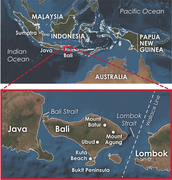
Created by the northward subduction of the Indo-Australian Plate beneath the Eurasian Plate, the Sunda volcanic arc includes the western Indonesian islands of Bali, Sumatra and Java. The Wallace Line, named after British naturalist Alfred Russel Wallace, marks a sharp distinction between the archipelago's northwestern and southeastern fauna. Credit: Kathleen Cantner, AGI.
Indonesia has the greatest number and highest density of active volcanoes of any country in the world, thanks to its location near the boundaries of multiple tectonic plates in what is widely considered the most tectonically complex and one of the most tectonically active regions on the planet.
Slightly larger than Delaware but with 4.5 times the population, Bali is just a few kilometers east of the much larger island of Java. Along with Sumatra, the three isles comprise most of western Indonesia’s Sunda volcanic arc, a curving chain of volcanically active islands created by the northward subduction of the Indo-Australian Plate beneath the Eurasian Plate.
As the Indo-Australian Plate dives below about 100 kilometers depth, mounting heat and pressure squeeze water out of the subducting plate and its sedimentary blanket. This water lowers the melting point of the overlying mantle, helping generate magma. Less dense than the surrounding rock, the magma migrates toward the surface to erupt and create the chain of volcanic islands, including Bali, that parallel the subduction zone a few hundred kilometers north of the deep-sea trench where the two plates meet.
Subduction in this region began after the breakup of Gondwana, one of two landmasses that made up Earth’s last supercontinent, Pangaea. As Gondwana disintegrated, Australia and Antarctica parted ways about 85 million years ago. Australia began creeping northward, initially at the leisurely pace of a few millimeters per year. About 45 million years ago, this separation accelerated to the current, rapid rate of 7 centimeters per year. At that time, Cenozoic subduction beneath the Sunda volcanic arc began, and it has occurred continuously since.
Our excursion to Bali was meant to be a relaxing family beach vacation on a tropical island. But my kids had been enticed by glossy brochures promoting a middle-of-the-night ascent of Mount Batur, one of Bali’s two active volcanoes. My son wanted to see the sunrise from the top; my daughter wanted to eat eggs hard-boiled in volcanic steam. Given that I’ve hiked up plenty of volcanoes, my preference was to sleep. Fortunately, I was overruled.
After my kids successfully roused me from sleep at 2:00 a.m., our driver transported us to a local coffee plantation where we sleepily snacked on fresh banana pancakes and sampled Luwak (or civet) coffee. Reputed to be the most expensive coffee in the world, this Indonesian delicacy is made from coffee berries that have been eaten, digested and defecated by small, weasel-like Asian palm civets — a process that selects for the best beans and gives the coffee a unique flavor.
After digesting this information, we were driven to the Batur trailhead, where we met our guide and began the hike up the volcano, with the aid of flashlights, at 4:00 a.m. Familiar with early-morning ascents, our family found the hike straightforward and not too strenuous, although there are numerous sheer drop-offs — and the occasional monkey — to avoid along the way.
When we reached the crater rim well before sunrise, our genial guide took us to a less-crowded viewpoint on the volcano’s northeastern flank. While we waited there for sunrise, he helped us clamber below the rim to visit a series of steaming fumaroles, into which he placed our eggs to hard boil for breakfast. As the sun slowly rose, the beauty of our setting became apparent. To the west, Batur’s steep-sided, 150-meter-deep crater dropped precipitously below our feet. To the southeast loomed the 3,014-meter-high Mount Agung, Bali’s highest peak and the island’s other active volcano. To the east, the crescent outline of Lake Batur glistened in the dawning light.
Batur and Agung are both stratovolcanoes, explosive cones built from layer upon layer of lava and ejected pyroclastics. From the rim, we could see that modern Mount Batur is nestled in the center of two huge concentric calderas — circular depressions created by the collapse of former volcanic mountains after massive eruptions emptied the underlying magma chamber.
Lake Batur is located inside the larger caldera, which collapsed about 29,300 years ago following an eruption of roughly 84 cubic kilometers of material. (For comparison, the 1980 eruption of Mount Saint Helens ejected 1.1 cubic kilometers of ash.) The inner 7.5-kilometer-wide caldera formed about 20,150 years ago. Bali is also home to Buyan Bratan, a second and older caldera system located west of Batur that attests to a long history of volcanic unrest.
Today, both Agung and Batur are considered armed and dangerous. In 1963, after 120 years of dormancyupted violently, killing about 1,600 people. Mount Batur, meanwhile, has erupted 28 times between 1804 and 2000. The most recent unrest, a series of small earthquakes in 2009 and 2010, forced officials to temporarily close the peak to climbing. The last eruption occurred in 2000, when a cloud of ash rose 300 meters above the rim. The most recent lava flows erupted from Batur in 1968; you can see the relatively fresh surface left by the flows as you descend from what, on a clear day, seems like the top of the world.
In 2012, Mount Batur was added to the Global Geopark Network (www.globalgeopark.org), which currently includes 100 parks in 30 countries. Locals and officials are hopeful that Indonesia’s first geopark will draw more of Bali’s 3.2 million annual visitors to Batur’s slopes, as well as to Kintamani, the village located along Lake Batur’s sparkling blue shore that features developed hot springs and Indonesia’s first volcano museum.
Within the Indonesian archipelago, Bali occupies a unique geologic position: It is perched on the eastern edge of Sundaland, Southeast Asia’s continental core (a large block of continental crust on the Eurasian Plate that includes Indochina, the Thai-Malay Peninsula, Sumatra, Java and Borneo, as well as the shallow marine shelf stretching in between). East of Bali, the Eurasian Plate consists of oceanic crust, so Bali is the easternmost island where subduction is occurring beneath continental crust.
This geologic difference is apparent when comparing the island’s adjacent straits. To the west, the Bali Strait — just 2.4 kilometers wide at its narrowest — separates Bali from Java. Overlying buoyant continental crust, the strait’s maximum depth is only about 60 meters, whereas the wider Lombok Strait to the east, which overlies denser oceanic crust, is more than 1,300 meters deep. This difference has significant biogeographical implications that were first recognized in the mid-19th century by Alfred Russel Wallace, a British naturalist best known for founding the science of biogeography, the science that studies the distribution of species. Wallace is often considered — along with Charles Darwin — one of the co-founders of the theory of evolution.
During the eight years that Wallace spent traveling through the region, he noticed a sharp distinction between the archipelago’s northwestern and southeastern fauna despite the regions’ similar climates and terrains. Wallace noted that Sumatran and Javan fauna are ecologically similar to species on the Asian mainland, whereas the fauna on the southeastern islands, including some marsupials, are closer to the species of Australia.
Wallace thus traced a boundary, later named the Wallace Line, which divides the Asian, or Sino-Indian, from the Australasian faunal regions. This important boundary passes between the islands of Bali and Lombok and corresponds to the edge of the shallow Sundaland continental shelf, the islands of which were linked or nearly linked as a continuous landmass during the Pleistocene glacial maxima. At that time, global sea levels were up to 120 meters lower than today, making it relatively easy for Asian species to migrate as far east as Bali. In contrast, due to its underlying oceanic crust, the Lombok Strait still presented a formidable barrier to migration.
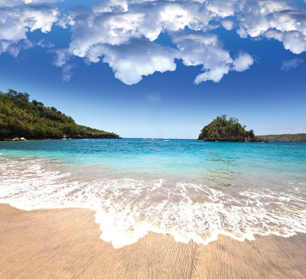
Bali’s seemingly endless beaches are its biggest draw, particularly those ringing the southernmost Bukit Peninsula and the narrow neck of land leading to it. This strip of land is a tombolo, a sand spit or bar that connects an island with the mainland. The tombolo is the site of both Bali’s airport, built here to take advantage of the flat land and the ability to extend the airfield into the sea, and the island’s biggest beach resorts. Thus, as you sit in a cozy beanbag chair watching the sunset from one of the many outdoor bars lining the southwestern beaches, you can raise a cold Bintang beer to the departing planes of those poor souls who have already finished their vacations.
The beach is very important to the lives and beliefs of the Balinese, and despite the large numbers of tourists, I often noticed groups of Balinese swimming, gathering on the beach, or participating in a beachside religious ceremony. The Balinese leave small trays of colorful religious offerings almost everywhere, including on the beach, scattered between lounge chairs, umbrellas and surfboards.
In the last few decades, 15 percent of Bali’s 430-kilometer-long coastline has suffered serious erosion due to wave action, storms and human activities. Between 1996 and 2004, the Indonesian government implemented nearly $80 million in engineering solutions, including breakwaters, jetties and sand replenishment, to combat erosion. Although the structures succeeded in halting erosion at several locations along the southeast coast, they were deemed not worth it because they were eyesores during low tides.
Likewise, when the current airport was built near Kuta Beach in the late 1960s, its airfield projected 1,000 meters offshore. Since this installation, the beach to the south has eroded more than 330 meters. Officials blamed this erosion on traditional coral mining, but in reality the airfield acted as a giant obstacle, blocking natural sand replenishment carried by the north-to-south longshore drift.
Despite most of the island’s volcanic origins, the Bukit region has a number of beautiful white sand beaches. This sand is locally sourced from the erosion of modern coral reefs, which comprise 18 percent of Bali’s coastline, uplifted Pliocene- to-Pleistocene-age coral reefs, and uplifted limestone and sandstone dating to the mid-Miocene that underlie southern portions of the island. Some geologists have proposed that these rocks were raised above sea level by a diapir (mud volcano) in a process similar to the diapirism observed on the Caribbean island of Barbados. Once uplifted, these rocks quickly erode, and longshore drift carries the resulting sand counterclockwise around the peninsula to create the sugary beaches for which southeastern Bali is justifiably famous.
From active volcanoes and white sand beaches to colorful celebrations and comfortable beanbags, Bali beckons.
© 2008-2021. All rights reserved. Any copying, redistribution or retransmission of any of the contents of this service without the expressed written permission of the American Geosciences Institute is expressly prohibited. Click here for all copyright requests.