
by Subrata Purkayastha & Jordan Clary Friday, June 1, 2018
The high Meghalaya Plateau in northeastern India was named for the mist that often blankets its hills and forests. Meghalaya means Abode of the Clouds. Credit: Jordan Clary
While most of India swelters through the hot monsoon season, which runs from approximately June through September, the picturesque town of Shillong, on the Meghalaya Plateau in northeastern India, offers a welcome respite from the heat. Meghalaya, which translates to Abode of the Clouds, was aptly named for the mist that often hovers over the region, and the climate is salubrious, with the warmest months averaging 20 to 22 degrees Celsius. For the geo-traveler, Meghalaya offers abundant opportunities to explore some of the oldest geological formations on the planet and a glimpse of a unique area of southern Asia that travelers to India often overlook.
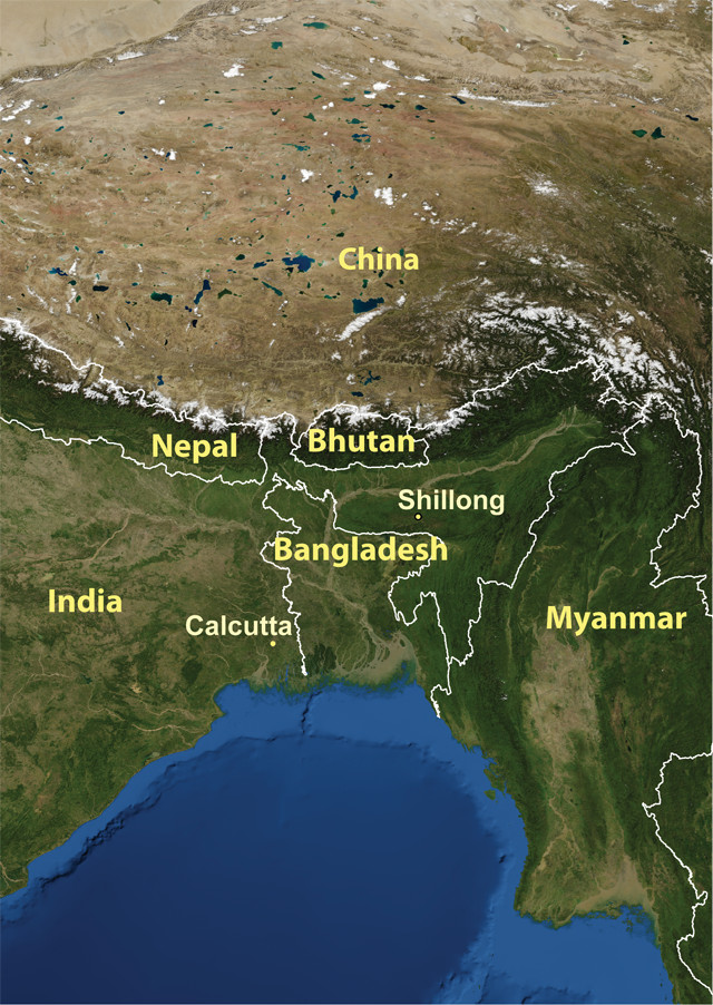
The Chicken Neck of India
Credit: kathleen Cantner, AGI
Set apart from mainland India, Meghalaya lies in the northeast, connected only by what is often called the “chicken neck” of India, the thin strip of land sandwiched between Bangladesh to the south and Bhutan to the north.
The geological formations here are a remnant of the ancient landmass of Gondwana, and are similar to those found in the Indian region of Gondwana on the northern Deccan Plateau to the south, where the famous supercontinent was first identified. In Meghalaya, Lower Gondwana rocks can be found in the western part of the Garo Hills and consist of Carboniferous- to Permian-aged pebble bed, sandstone and carbonaceous shale. The Meghalaya Plateau is the easternmost continuation of the Chota Nagpur Plateau of the Deccan foreland and is separated from the Rajmahal Hills of Chota Nagpur by the Rajmahal-Garo Fault. Here, the Ganges and the Brahmaputra, along with their tributaries, have deposited rich alluvium soil.
The plateau has a long tectonic history, including periods of mountain building, submergence during marine transgressions and peneplanation — the formation of flat plains by erosion — with several phases of erosion, sedimentation, folding, faulting and intrusion. The plateau juts out between the Surma Valley of present-day Bangladesh in the south and the mighty Brahmaputra plains in the north — directly in the path of the torrential monsoon showers generated by the cyclonic air mass churning in the Bay of Bengal each summer. In fact, the southern slopes of the Meghalaya Plateau have the highest rates of rainfall in the world.
The Scotland of the East
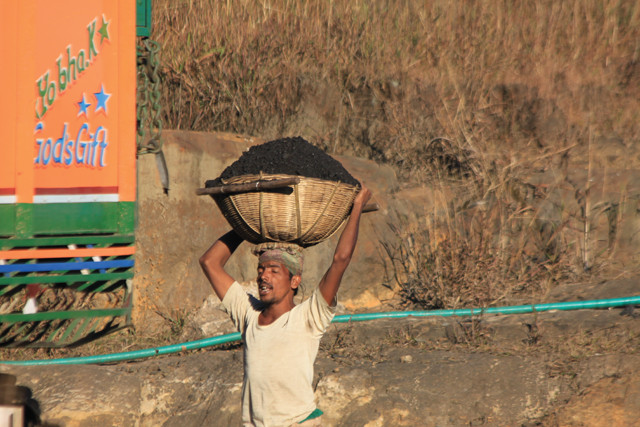
A miner carries a basket of coal on his head. Many former forested areas are being stripped to mine coal. Credit: Jordan Clary
Shillong, a city of 143,000, and its suburbs are located in the central upland zone, which is the highest part of the Meghalaya Plateau. The town is situated on a horst with a landscape similar to Scotland, earning it the moniker “the Scotland of the East.” To the south of the city lies Shillong Peak with an elevation of 1,916 meters, the highest point on the plateau. This central upland zone was formed by repeated cycles of erosion that left well-defined peneplains at high elevations along the Shillong Ridge, where a number of streams originate and flow north toward the Brahmaputra Basin or south toward the Surma Basin. Shillong proper, situated on the northern slopes of the Shillong Ridge, has an elevation ranging between 1,440 and 1,500 meters, while the Umkhrah Valley below reaches 1,410 meters.
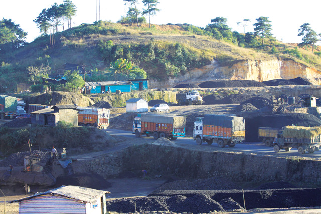
Trucks carrying coal and bamboo wind along narrow roads. Credit: Jordan Clary
The rocks here are of ancient Archean and Precambrian age and consist of hard crystalline granites, gneisses and granulites with intrusions. The Precambrian Shillong rock group consists of quartzites, phyllite and conglomerate. Towards the western and southern margins of the plateau, rocks were deposited during a marine transgression in the Mesozoic and Early Tertiary, when the Tethys Sea submerged the region. During the Himalayan orogeny, the plateau was uplifted from the ancient Tethys Sea. Today, Shillong exhibits numerous faults, fractures and troughs indicating recent tectonic activity. Citizens are well aware they reside in an earthquake belt.
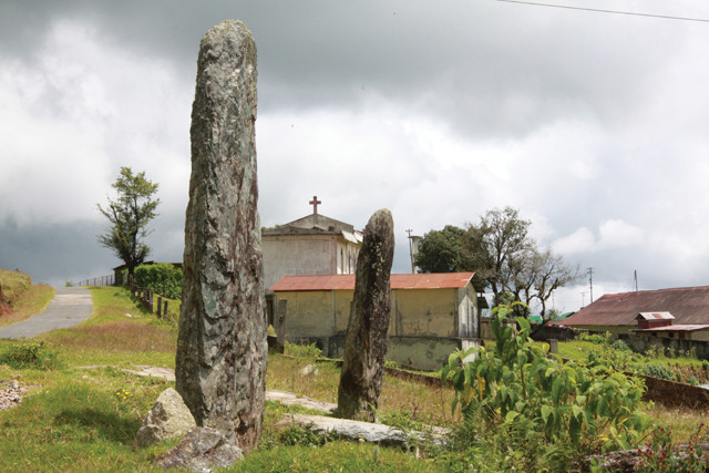
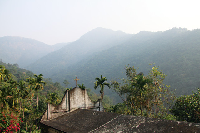
Old meets new: Ancient Khasi standing stones, which once marked places of sacrifice and ritual, stand in front of a Christian church. Credit: Jordan Clary
Tribal Villages and Living Bridges
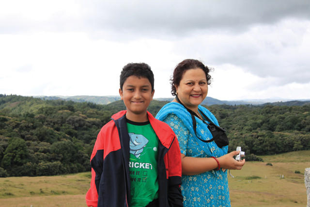
Author Subrata Purkayastha and her son Rahul at Mawphlang Sacred Forest, a virgin forest considered sacred by the Khasi tribal people. Credit: Jordan Clary
Shillong was founded in 1863, during British colonization, and later declared the capital of Assam Province. Shillong emerged as an enclave of western modernity amid traditional tribal society. Today the city is an important educational hub of northeast India, and one of its major urban centers. But prior to 1863, Shillong consisted of dense forest where small hamlets and other surrounding rural settlements existed under the jurisdiction of tribal chiefs. The indigenous populations here belong to the Khasi and Jaintia tribes, both matrilineal societies with unique customs and traditions, as well as primitive economies based on the slash-and-burn agricultural practice known locally as “jhum.”
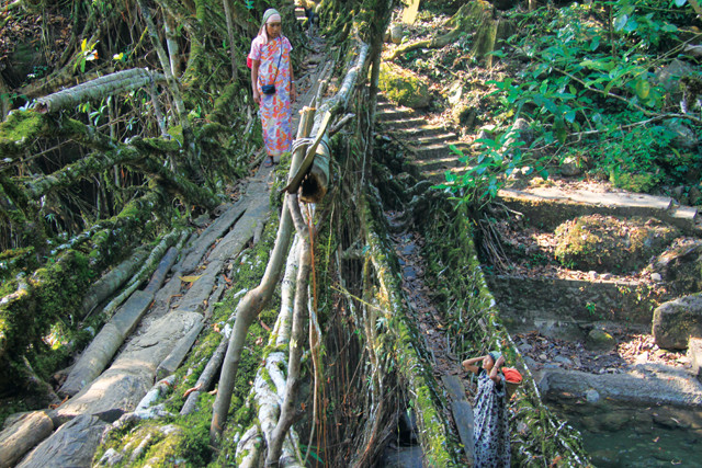
Two Khasi women stop and chat on the living bridges, formed from the roots of rubber trees, in the village of Nongriat, near Cherapunjee, Meghalaya. Credit: Jordan Clary
Traditionally, land and forests are a common resource owned by small clans. The forests are cleared by the clans and used for agricultural purposes. After some time, when the fertility of land declines, the land is left fallow and the clans move to a new stretch of forestland, clear it and use it for agriculture. This cycle continues until they come back to the first clearing after a gap of 15 to 20 years. With the demands of increasing population size, however, the jhum cycle today has been reduced to 3 to 5 years, leading to severe deforestation.
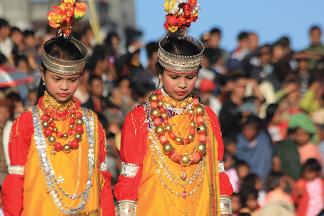
Two Khasi girls at the Nongkrem dance keep their eyes downcast as a sign of modesty. Credit: Jordan Clary
Today, many of the Khasis are city dwellers. In the remote areas of the countryside, however, some villagers continue to live as they have for hundreds of years. Some of these villages are only accessible on foot, by hiking several kilometers on steep trails.
One such village is Nongriat, which rests at the bottom of a steep ravine that is inaccessible by vehicles. Nongriat is known as the home of the “living bridges.” Made from the roots of Ficus elastica trees, a type of Indian rubber tree, the bridges span the rivers connecting the village trade routes. Some are centuries old. Others are just now in the process of being created and may not be usable for another generation or more. Ecologically sustainable, they withstand monsoon floodwaters in ways that steel bridges never can.
Green Valleys, Waterfalls and a Natural Golf Course
The Shillong area consists of five physiographic divisions. Shillong’s topography is composed of rolling hills and valleys with varying relief marked by hills and meadows of lush green grasses and thick pine forests.
The Shillong Ridge, an area of thick pine forests, marks the southern boundary of the city and is where the streams and springs originate that provide the local water supply.
The natural beauty of the area includes a number of breathtaking waterfalls such as Spread Eagle on the Umkhrah Stream, Sweet Falls on the course of Umkhen Stream, Elephant Falls close to the Shillong Ridge, and the Beadon and Bishop Falls located in the southwestern part of Shillong. Most of these are an easy daytrip, which takes you along trails where wild orchids wrap around tree trunks and the moist air is tinted by green foliage. The area suggests the presence of youthful topography in an ancient Precambrian shield.
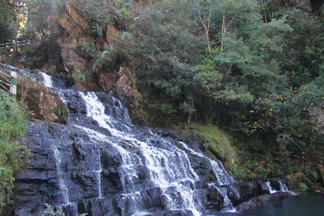
Elephant Falls near the city of Shillong in Meghalaya, India. Credit: Jordan Clary
On the southwestern slope of the Shillong Ridge lies the scenic valley of Umshyrpi. The Laitumkhrah-Mawkhar upland is located in the central part of the city and separates the Umkhrah from the Umshyrpi Valley. Shillong’s downtown area and the city’s major shopping district, called the Police Bazaar, are located here, as is the European Ward, which housed the colonial power.
Skirting the northwestern edge of the city is the Umkhrah-Umshing watershed divide. To the north, below Shillong proper, lies the Umkhrah Basin. In the late 1800s, the British colonial powers took advantage of the undulating topography here to develop a golf course similar to the links courses originally developed in Scotland. Rather than being smoothed over, the natural bumps and slopes of the topography remain part of the fairways and greens. It is one of the oldest, highest and wettest golf courses in the country.
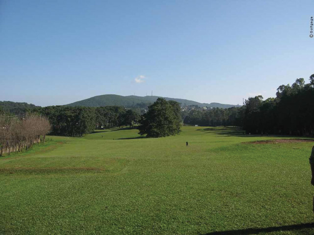
The natural golf course at Shillong — one of the oldest, highest and wettest courses in India — was built by the British, who introduced golf to India in the late 1800s. Credit: Courtesy of Ruturaj Ingle
If you are planning a trip to India, consider spending some time in this northeastern enclave that unites the ancient, traditional and modern. You can visit the remnants of Gondwana, hike across a living bridge, meet members of a matrilineal tribe or shoot a round of golf, all in the Abode of the Clouds.
© 2008-2021. All rights reserved. Any copying, redistribution or retransmission of any of the contents of this service without the expressed written permission of the American Geosciences Institute is expressly prohibited. Click here for all copyright requests.