
by Meg Marquardt Wednesday, August 14, 2013
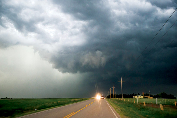
The collision between warm and cold air causes convective instability as the warm air is pushed upward into colder layers, leading to cloud formation. Such instability, when combined with wind blowing in opposite directions and at varying speeds at different heights, can cause tornadoes. These supercells, photographed by Virginia Tech meteorology students in May in Oklahoma, produced tornadoes. Trevor White
In 2011, more than 1,600 confirmed tornadoes touched down in the United States. The twisters killed more than 550 people, injured more than 5,400, and resulted in economic damage that soared into the billions. By mid-July 2013, close to 500 confirmed tornadoes had already touched down, killing 44 people, half during the single storm that hit Moore, Okla., on May 20. Although individual tornadoes can’t be predicted, new research from a team of scientists at NOAA’s Atlantic Oceanographic and Meteorological Laboratory in Miami, Fla., suggests that severe tornado outbreaks may be linked to specific weather patterns.
Tornado outbreaks often form when warm, moist air from the Gulf of Mexico collides with cold fronts moving down through Canada. The meeting of the two fronts causes convective instability as the warm air is pushed upward into colder layers, leading to cloud formation. Such instability, when combined with wind blowing in opposite directions and at varying speeds at different heights in the atmosphere — a phenomenon known as vertical wind shearing — can cause tornadoes.
The El Niño Southern Oscillation also appears to have some impact on the conditions that lead to exceptional tornado outbreaks, says David Enfield, a physical oceanographer at the University of Miami’s Rosenstiel School of Marine and Atmospheric Science and co-author of a new study in the Journal of Climate. Specifically, past studies have indicated that large tornadic events are linked to Trans-Niño years, characterized by trans-Niño index (TNI) values during either the onset or ebbing of El Niño or La Niña conditions, when variation in sea-surface temperatures in the Pacific Ocean can be considerable. Why the transitional years seemed to spawn more tornadoes remains unknown.
With regard to individual events, “what we’ve realized during our tornado studies is that a correlation could be misleading or not really important,” says Sang-Ki Lee, a NOAA specialist in atmosphere-ocean dynamics and lead author of the study. So many different factors can impact individual tornado formation, he says, that it’s difficult to tease out what may be the singular cause behind an event.
For this reason, the researchers turned their attention to larger events, specifically swarms of tornadoes called super outbreaks. They used a two-pronged approach employing both historical records and meteorological computer modeling. The historical data came from NOAA’s Severe Weather Database, which collects civilian reports, damage surveys and Doppler radar information to catalog tornadic events. The team focused on the 10 largest outbreak years from 1950 to 2010, when there was the greatest incidence of tornadoes ranked F3 through F5 on the Fujita-Pearson severity scale. Such years include the 1974 outbreak that spawned 148 confirmed tornadoes — 60 of which were F3 or larger — across an area that stretched from Ontario to Alabama.
Of the 10 most active years, seven occurred when the TNI was in a strongly positive phase, Lee says. When the TNI is in a positive phase, sea-surface temperatures in the central tropical portion of the Pacific Ocean are colder than average, while those in the eastern zone tend to be warmer than average. In those years, the number of large-scale tornadoes was twice that of a neutral or negative TNI year.
A general atmospheric circulation model supported the observational data; during positive phase TNI years, there is a slight shift of the jet stream to the north, which brings in more cold, dry air from Canada. Because of large-scale atmospheric teleconnections, there is also an increase of warm, moist air from the Gulf of Mexico. This leads to an increase in lower atmospheric vertical wind shear over the central and eastern portions of the United States, the final piece of the puzzle. All of these conditions are ideal for producing severe tornado outbreaks, Lee says.
Such research aims to “find a basis for making a prediction for enhanced activity for a few weeks or a month” ahead of time, says Michael Tippet, a senior researcher in prediction sciences at Columbia University, who was not affiliated with the study. Although it could not be used to predict the exact timing of an outbreak, the TNI model would be similar to that used to anticipate the Atlantic hurricane season each year, he says, which would help emergency services better prepare for a rough season. “There’s no such product for tornadoes,” he says. “But that would certainly be a desirable [system].”
Though the data were not included for this study, raw data from spring 2011 suggest that the TNI was in a positive phase, perhaps contributing to the massive super outbreaks that year. By contrast, 2013 shows signs of a negative TNI phase, suggesting that it could be a milder season.
© 2008-2021. All rights reserved. Any copying, redistribution or retransmission of any of the contents of this service without the expressed written permission of the American Geosciences Institute is expressly prohibited. Click here for all copyright requests.