
by Carolyn Gramling Thursday, January 5, 2012
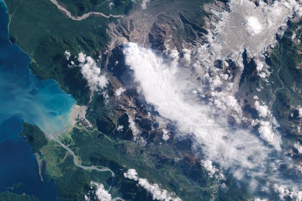
Chaitén's eruption sent a cloud of ash wafting over Chile, Argentina and the Atlantic Ocean. NASA image created by Jesse Allen, using EO-1 data provided courtesy of the NASA EO-1 team
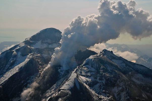
Alaska's Redoubt volcano erupted violently in the spring of 2009. Chris Waythomas, Alaska Volcano Observatory, USGS
For more than 9,000 years, Chaitén volcano quietly towered 1,122 meters over southern Chile. The volcano seemed almost asleep: Its wide crater, shaped by layers of ash and pumice from an ancient eruption, held two lakes and a giant dome of obsidian — the same glossy black rock that was used in prehistoric times to shape artifacts found at archaeological sites as far as 400 kilometers away. Almost at the foot of the volcano, just 10 kilometers to the southwest, a small village grew into the town of Chaitén, population 4,200.
Then, on May 2, 2008, the volcano burst back to life. The eruption intensified over the next week, shooting plumes of hot ash, rocks and sulfur-choked steam 30 kilometers into the sky. Pyroclastic flows of hot gas and rock swept down the mountain. Meanwhile, ash from a first and then a second powerful eruption drifted across Argentina and into the Atlantic Ocean.
Airlines began cancelling flights at airports in Chile, Argentina and Uruguay. Argentina’s Bariloche airport, in the foothills of the Andes, canceled more than 150 flights. But five aircraft flying routes near Bariloche encountered volcanic ash clouds drifting at an unusually low altitude of less than two kilometers, according to a 2008 study by U.S. Geological Survey volcanologist Marianne Guffanti, based in Reston, Va. Several of the planes suffered engine damage; one of the planes suffered turbine damage that cost the airline $2.5 million, but all landed safely.
That sort of thing doesn’t happen very often anymore. Since the 1990s, a global, cooperative network of nine ash advisory centers, each responsible for large swaths of the planet, has tracked the dispersion of volcanic ash in the atmosphere, exchanged information and issued warnings to pilots. Overall, experts say, the system has greatly improved aviation safety.
But the system is only as strong as its weakest link. And the near catastrophes at Chaitén, scientists say, highlight a weak link in the ash advisory network: a worldwide need for better real-time monitoring data on many volcanoes around the world, particularly in the remotest regions. Without those data, the ash advisory centers are, in some cases, flying blind.
International airlines fly routes traversing developed and developing countries alike, and many of these countries have few resources for hazard monitoring on the ground, let alone in the air, says Andrew Tupper, regional director of the Northern Territory Bureau of Meteorology in Australia. “We’ve managed to set up a worldwide system of flight paths over volcanoes that are not necessarily monitored,” Tupper says. So between the crisscrossing paths of nations, observatories and airlines, a spirit of cooperation may be the best way to improve safety in the air.
Volcanic eruptions are relatively rare, but when they do occur, the bits of pulverized rock and glass in the eruptive cloud can present a significant danger to planes: The ash can get into the turbines and cause engine failure, block fuel nozzles and gum up landing gear. Or tiny particles of glass can sandblast a windshield, says Bill Rose, a volcanologist at Michigan Tech University in Houghton.
From 1973 to 2000, commercial aircraft reported nearly 100 encounters with volcanic ash clouds, according to a 2004 report that Guffanti co-authored. One of the most harrowing encounters occurred during a 1989 KLM flight from Amsterdam to Anchorage: The plane entered a cloud of ash that had erupted from Alaska’s Redoubt volcano and lost power to all four engines, dropping more than 4,000 meters before the pilot managed to restart the engines.
There have been other near misses, but volcanic ash has not caused any actual crashes or deaths, Guffanti says. It is, however, a possibility, she adds.
The incident with the KLM flight was one of several during the 1980s that led the International Civil Aviation Organization (ICAO) to set up a worldwide volcanic ash monitoring system. ICAO, a U.N. agency, established nine Volcanic Ash Advisory Centers (VAACs) around the world in the 1990s. Together, these VAACs comprise the International Airways Volcano Watch.
Rather than being created specifically to track volcanic ash, each of the centers is run by an already existing meteorological organization in its host country. “It’s not like somebody went out and bought a new building,” Guffanti says. “It’s basically an added duty.”
The United States, for example, is home to two VAACs, both connected with NOAA — one in Alaska, part of the Alaska Aviation Weather Unit in Anchorage, which works closely with the Alaska Volcano Observatory, and one in Washington, D.C., part of both the National Environmental Satellite, Data and Information Service and the National Weather Service.
Meteorologists at each VAAC play a coordinating role, collecting information from satellites, radar, observatories and even pilot reports to determine the intensity of an eruption. They run models to create a three-dimensional picture of how the ash is moving and forecast where it will go, and then issue an advisory statement to alert local meteorological offices as well as the aviation community. It’s a cooperative system, with a lot of built-in redundancy, Guffanti says. For example, the initial report of an eruption comes from many sources.
As for volcano training, Rose says, the meteorologists and other staff at the VAACs learn that on the job. Staff members from the VAACs also travel to regional and international meetings periodically, exchanging ideas, information and new models. “They had to learn nontraditional things,” he says. “Meteorology people are very familiar with the remote sensing of things like thunderstorms and cloud formations, how to forecast the weather. But they don’t know what to look for when there is an eruption. There’s a whole different pattern: An eruption starts out very suddenly, and you get this cloud moving rapidly upward, a cold cloud that looks a lot like a thunderstorm.” The early phase of the cloud is full of ice, he says — then it evolves, and the ash becomes visible.
“The problem is that it doesn’t happen everyday, so it’s hard to learn,” Rose adds. “In meteorology, there’s something going on every day that you can learn from. But for eruptions, you can’t do that. There are only a few a year, and usually nowhere near you. You don’t have direct access to data as much; you have to look at old data from the other side of the Earth to see an example.”
Still, the VAAC system has been a broad success, overall, Rose says. “Everybody’s happy with them. The airline companies really like the service.”
The VAAC responsible for monitoring Chaitén is based in Buenos Aires, Argentina, and is operated by the Servicio Meteorológico Nacional of Argentina. The Buenos Aires VAAC watches for ash clouds from historically active volcanoes across the southern half of South America, including Chile’s busy Llaima and Peru’s Ubinas.
Long-dormant Chaitén, meanwhile, which had not erupted in historical times, was hardly considered a major trouble spot. In fact, like many of the world’s quieter volcanoes, Chaitén was largely devoid of seismic monitoring stations, webcams or other real-time observational equipment. Therefore, the Buenos Aires VAAC had to use somewhat more delayed data from satellites to detect the Chaitén eruption, Guffanti says.
Still, the Buenos Aires VAAC did what it could. In September 2008, the VAAC presented a report to ICAO, which stated that it issued more than 200 volcanic ash advisories during the Chaitén eruption in May and June. The report also noted one encounter between an airline, LAN Argentina, and volcanic ash from Chaitén on May 6. The plane was flying from Buenos Aires to Bariloche; as it descended into the Bariloche airport, the plane entered a low-level ash cloud. The pilots, the report stated, knew of a powerful eruption that had occurred about five hours earlier, but did not know that a second eruption had happened, emitting the new cloud. Although the pilots managed to land successfully, the plane’s engines were choked with ash.
The centers use dispersion modeling to track where an ash cloud is likely to go, information that they then provide to pilots. But this modeling can be tricky. Once an eruption starts, the VAAC uses models to project where the cloud is likely to be in six, then 12, then 18 hours. “That’s difficult scientifically as well as operationally,” Guffanti says. For one thing, she says, modeling the dispersion of the ash particles over time requires making certain assumptions about initial conditions. “Assumptions and approximations are built into it,” she says. “Nobody can get away from that.”
In the case of Chaitén, there were other complicating factors: For example, the chemical composition of the ash itself. Chaitén produces rhyolitic explosions with ash relatively low in sulfur dioxide, making it difficult for satellites to “see” and provide information for accurate modeling. The geography of southern South America also complicates ash dispersion models: The Patagonian winds come across the Andes Mountains and sweep across the flat plains of Argentina, carrying ash low to the ground — particularly difficult for planes trying to land or take off. The ash was not evenly distributed around airports either, Guffanti says. “There were micro-variations: Planes coming from the north were not affected, but planes that looped around from the south were,” she says. Modeling these movements at a larger scale is fiendishly difficult.
Papua New Guinea, home to dozens of volcanoes, falls under the aegis of a VAAC based in Darwin, Australia, which is also responsible for many of the most active volcanoes in the Pacific Ocean, including those in Indonesia and the Philippines. One of Papua New Guinea’s volcanoes, Manam, began erupting in October 2004, producing pyroclastic and lava flows so destructive that the entire island of Manam — home to about 9,000 people — was evacuated.
Multiple sources provided information on the volcanic cloud to the Darwin VAAC during the eruption: ground monitoring (visual and aural observations, as well as data from a single seismometer in the village of Warisi); satellite-based cloud-height analysis; satellite ash, aerosol and sulfur dioxide detection; and direct observations from pilots.
But in many cases, the reports conflicted when it came to how high the ash clouds were, making it difficult to issue appropriate warnings, according to Tupper, who helps run the Darwin VAAC. The Darwin VAAC analyzed these different reports in a 2007 paper in the journal Weather and Forecasting. Part of the difficulty, they reported, stemmed from the high ice content in the clouds, which made them difficult to track — highlighting a key problem, Tupper says. A VAAC’s ability to provide warning is only as good as the data it can amass.
No eruption is simple, he says: An ice- or water-rich ash cloud, such as the Manam cloud, may be undetectable for days or even weeks after an eruption, but is potentially still dangerous. “It’s a brave meteorologist who would keep a warning going for that long without any verification from observations,” he says. And there’s the problem of seeing through other meteorological phenomena to track more elusive ash: For example, anvil-shaped thunderstorm clouds can obscure satellite detection of lower eruption clouds. Or water-rich ash clouds may even resemble thunderstorms themselves.
One needed improvement, Tupper says, is better integration of satellite-based, ground-based and pilot-based observations and systems — a sentiment discussed at the World Meteorological Organization’s 4th International Workshop on Volcanic Ash, which met in New Zealand in 2007. Many of the remotest volcanoes, deep in the Pacific or high in the Arctic, are largely unmonitored by ground-based systems — often because they pose little threat to populations on the ground, and so are not considered a priority. “We are grappling with the issues of how these observatories might monitor remote volcanoes to the necessary standard,” he says. But that means realigning both priorities and (often scarce) funding.
The aviation industry as a whole needs to be more actively involved in the issue, Rose says. Airlines obviously do not want to draw too much attention to this danger, particularly when it’s rare, he notes. But to move things forward, cooperation from the aviation industry will be essential.
Graham Rennie, the manager of flight dispatch for Australia’s Qantas Airlines, also represents the International Air Transport Association on the International Airways Volcano Watch’s operations group. Many aviation industry-related groups, including the International Air Transport Association and the U.S. Federal Aviation Administration (FAA), are aware of concerns about volcanic ash and are actively working on them, Rennie says. And some airlines do prioritize these issues, even talking directly to volcano observatories and participating in scientific discussions at the national and international levels.
But some airlines, he acknowledges, can be too slow to come to the table when there isn’t a volcano actively churning out ash. “This is a great shame for aviation, because — just from an efficiency standpoint — volcanic ash events can be very costly,” Rennie says. Once a large eruption occurs, it’s too late to make major advances, he adds. “So it’s during the quiet periods that the appetite should be greatest, with everyone banging the table for incremental progress.”
Still, he says, airlines are businesses — and they need a consensus of information on which to base any adjustment to their business models. “During every eruption, there is a flood of e-mails from the scientific community making observations and assumptions … I’m very aware that this must happen to progress remote sensing, but to me it often appears fragmented.”
Indeed, the two communities often approach the question of how to monitor ash and issue advisories very differently, Tupper acknowledges. “The scientific community works with surges of cooperation, often-hidden competition and disagreement, and eventual broad consensus on outcomes,” he says. But that iterative process can lead to confusion, he adds. In the meantime, how does an airline know who to listen to, or which remote sensing algorithm is the best? “Airlines tend to be very focused on the here and now, and ‘real time’ to them is very different from the ‘real time’ of a volcanologist, who may not see their pet volcano erupt in their lifetime.”
Getting past the natural reticence of a business to spend money is where international organizations can take a lead, Tupper says, by helping to mediate between the different viewpoints to build a working warning system. ICAO has begun one initiative to help with this, he notes: The agency encourages charging the aviation industry for these meteorological services from observatories. That can make it possible for the observatories to recover these costs from airlines, although how that happens will be up to each country.
“We are just at the stage now of exploring how that really might work,” Tupper says. One sticking point, for example, is equity in distributing these costs among airlines: If only the more safety-conscious airlines take advantage of this information, they may incur costs that become unfairly distributed. The path to cooperation may be quite tricky, he adds. “I don’t want to paint too rosy a picture — this can be very frustrating.”
Although linked by ICAO, the VAAC network is somewhat decentralized, and each center has its own challenges. For example, different centers may use different dispersion models, and communicate with different local and national agencies in terms of hazard awareness and response, as well as with the other VAACs. In December 2008, Guffanti told scientists at the American Geophysical Union’s annual meeting in San Francisco, Calif., that at the time that Chaitén erupted, the Buenos Aires VAAC still relied on NOAA to run its ash dispersion model. One reason for this is that Buenos Aires didn’t have the latest version of the graphical software. And that wasn’t the only issue: In its 2008 report to ICAO, the Buenos Aires VAAC also indicated that its staff lacked formal training in VAAC operations, as well as in a model forecasting the trajectory and dispersion of volcanic ash, called HYSPLIT. Furthermore, the Buenos Aires VAAC requested that some of the ICAO International Airways Volcano Watch handbook information be published in Spanish.
In October 2008, Guffanti headed to Chile to brief the country’s officials, specifically Chile’s equivalent of the FAA, the Chilean Dirección General de Aeronáutica Civil, on hazard awareness and to work with them on how to lessen the impacts of volcanic ash on airports. USGS, she says, does a lot of hazard education, outlining (among other things) what’s in the ash clouds, how they behave, and how the VAACs track and forecast their movements. “It’s an overview of the global mitigation strategy of ash avoidance, set by ICAO,” she says.
Guffanti points out that since the Chaitén eruption, the Buenos Aires VAAC is now able to run NOAA’s dispersion model itself. The VAAC has also improved how it coordinates advisories with the adjacent VAAC (in this case, Toulouse, France), she says, regarding the ash clouds moving across the Atlantic Ocean.
The system works — but imperfectly, Guffanti says. Over time, she adds, ICAO’s system of volcano monitoring and ash cloud detection has decreased the frequency of dangerous encounters between airplanes and volcanoes. But there are many unmonitored volcanoes, for which the agencies can give no early warning. “Satellite remote sensing has inherent physical limitations,” she says. Part of it is physics — certain laws cannot be thwarted. For example, no matter how scientists fine-tune a satellite’s ability to see certain wavelengths, its UV sensor is only going to work in the daytime. And ash coated with ice is not as visible to satellites as uncoated ash.
“It doesn’t matter how smart or good the people are; models are just that,” Guffanti says. “They’re models, not absolute predictors.”
By July 2008, Chaitén had quieted, but the damage on the ground had been done: Ash blanketed large parts of southern Argentina and Chile. Pyroclastic flows had burned forests. An ash-choked mudflow called a lahar filled in the channel of the Chaitén River, which then forged a new course — flooding the evacuated town. Chaitén’s former residents were permanently relocated.
Last May, on the first anniversary of the Chaitén eruption, Governor Sergio Galilea of Chile’s Los Lagos (Lakes) Region gave an interview to Chile’s radio program Radio Cooperativa. The region is recovering, he told the program — but officials remain watchful. A new lava dome was growing in the crater, spitting gas and boulders of lava into the crater floor. “El enemigo sigue ahí,” he said: The enemy is still there.
Scientists at the Buenos Aires VAAC, and at other observatories charged with monitoring even more remote volcanoes, share a similar sentiment.
© 2008-2021. All rights reserved. Any copying, redistribution or retransmission of any of the contents of this service without the expressed written permission of the American Geosciences Institute is expressly prohibited. Click here for all copyright requests.