
by Bethany Augliere Tuesday, June 5, 2018
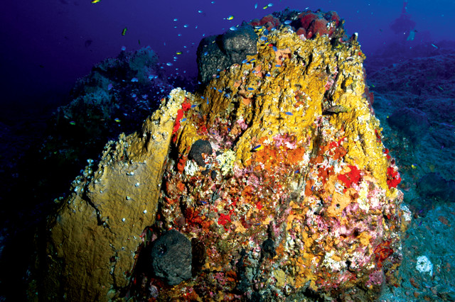
Fire coral (Millepora alcicornis) covers a rocky pinnacle in Flower Garden Banks National Marine Sanctuary. The reefs, which grow atop salt domes in the Gulf of Mexico, were discovered by fishermen in the early 1900s, and designated a marine sanctuary in 1992. Credit: NOAA.
On Aug. 25, 2017, Hurricane Harvey made landfall along the Texas coast as an unexpected Category 4 storm, with maximum sustained winds of 209 kilometers per hour. After rapidly intensifying over the Gulf of Mexico, it hovered over southeastern Texas for days, slowly weakening as it dumped 68 trillion liters of water onto the land — more than three times the volume of the Great Salt Lake in Utah.
That freshwater, potentially loaded with contaminants after flowing across the developed landscape, had to go somewhere. Researchers looking into where and how that immense amount of freshwater would impact the marine environment, including the delicate coral reef of the Flower Garden Banks National Marine Sanctuary about 185 kilometers offshore Galveston, presented their research at the 2018 Ocean Sciences meeting in Portland, Ore., in February.
There were two major concerns regarding this unprecedented amount of freshwater draining into the Gulf of Mexico, says Steve DiMarco, a physical oceanographer at Texas A&M University who led the recent research. First, the freshwater could potentially cause a low-oxygen dead zone, similar to the one that develops every summer off the Louisiana coast, which is fed by nutrient pollution from the Mississippi River. The dead zone would be exacerbated if the less dense freshwater formed a layer atop denser saltwater, resulting in stratification of the water column.
The second concern was whether the freshwater influx would reach Flower Garden Banks, one of the most northern coral reefs in the world. “It’s a stunningly beautiful coral reef,” DiMarco says. “If freshwater made its way out there, it could change the marine ecosystem and damage the coral reef.”
Earlier in the summer, DiMarco and his colleagues had already been surveying and observing the continental shelf off Texas for ongoing projects related to tracking oil spills, water quality and ocean circulation. In June and August, they conducted two surveys from ships to collect salinity, temperature and depth data at 25 locations. After the hurricane, the team secured funding to conduct additional surveys for a study comparing conditions in the Gulf before and after the storm that would help track the freshwater plume.
The researchers found that wind-driven currents in the Gulf pushed the freshwater south toward Mexico, rather than toward the marine sanctuary. “The winds shifted right after the hurricane, as water was moving out [to sea from land],” DiMarco says. “That saved Flower Garden.” The team tracked the plume as far south as South Padre Island, Texas’ southernmost barrier island. DiMarco and his colleagues alerted ocean researchers in Mexico that the freshwater plume could continue south across the border.
The researchers also found that the water did indeed stratify, with oxygen levels in the saline waters beneath a 20-meter-thick freshwater cap falling to about 50 percent of normal — potentially damaging to bottom-dwelling marine organisms like fish and crabs. By November, however, those oxygen levels had returned to normal, as is expected in the fall when winds mix the water.
One of the big lessons from Hurricane Harvey, DiMarco says, is that a seemingly innocuous, loosely organized storm could become a Category 4 hurricane so quickly. Normally, a storm has to pass over a large, warmwater current — like the Gulf Stream in the Atlantic Ocean or the Loop Current in the Gulf of Mexico — to develop into a hurricane. For Harvey, however, “there was no real big current; the Loop Current was far to the east,” he says.
Normally, the coastal Gulf waters in this region are warm on the top, but cold on the bottom, says co-author Henry Potter, an oceanographer at Texas A&M. In this case, the water was warm — 31 degrees Celsius — down to 50 meters depth. “Because the ocean was particularly warm, [it seems] the storm intensified very rapidly,” Potter says.
The observation that hot shelf waters can produce an intense storm under the right circumstances should lead to new hurricane models that include data on oceanographic variables, in addition to atmospheric data, which has not typically been done, says Kevin Trenberth, a climate scientist at the National Center for Atmospheric Research in Boulder, Colo., who was not involved in the study. “Hurricanes are essentially coupled phenomena,” he says. “The details of what’s going on in the ocean actually matter.”
© 2008-2021. All rights reserved. Any copying, redistribution or retransmission of any of the contents of this service without the expressed written permission of the American Geosciences Institute is expressly prohibited. Click here for all copyright requests.