
by Mary Caperton Morton Monday, January 5, 2015
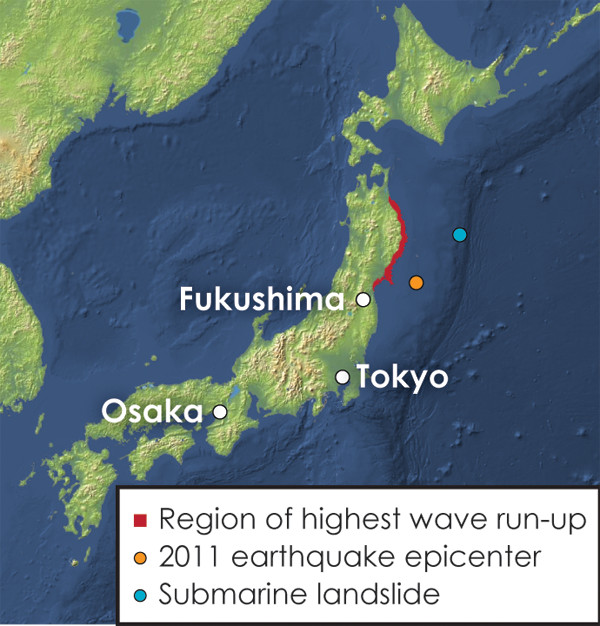
The highest waves during the 2011 Tohoku tsunami occurred about 100 kilometers north of the main rupture. Credit: Kathleen Cantner, AGI.
When the magnitude-9 Tohoku earthquake hit Japan on March 11, 2011, the mainshock triggered tsunami waves averaging about 10 meters in height by the time they reached the coast of Japan, from Fukushima in the south to the northern tip of Honshu Island. But one mountainous stretch of coastline known as Sanriku, about 100 kilometers north of the main rupture area, saw waves higher than 40 meters. This oddity has led some scientists to suggest that a submarine landslide, triggered by the earthquake, may have contributed to the tsunami’s extreme height in this region.
Initial investigations attributed the tsunami solely to the mainshock. “However, ongoing modeling suggests that you can’t create that wave without additional forcing,” says David Tappin, a marine geologist at the British Geological Survey, based in Keyworth, England, and lead author of the new study in Marine Geology.
Additional forcing could have come in the form of a second earthquake, north of the main rupture zone, but seismic records do not seem to show such an event, Tappin says. “So we went looking for evidence of a submarine landslide.”
One of the problems with studying submarine landslides is that only a small portion of the seafloor has been mapped in detail, so the chances of having data or images showing what a particular area looked like both before and after an event are slim. “Fortunately, Japan has been acquiring bathymetry data over decades, so were able to do a comparison,” he says.
Using bathymetry data collected before and after the 2011 event, Tappin and colleagues identified a slump of displaced sediment 20 kilometers long by 40 kilometers wide and up to 2 kilometers thick that appears to have slid about 300 meters down the slope of the Japan Trench. The slump would have acted like a piston, pushing a wall of water toward the Sanriku coastline and increasing the height of the tsunami waves in that region, he says.
But not everybody is convinced that a landslide occurred. “We conducted seismic imaging of the seafloor structure last year in the same area discussed by this paper, but we could not find any strong evidence of a large landslide in this area,” says Shuichi Kodaira, a geophysicist at the Japan Agency for Marine-Earth Science and Technology in Yokohama who was not involved in the new study.
The discrepancies between the findings from Tappin’s team and those of Japanese researchers may be due to uncertainties inherent in bathymetric mapping. “Seafloor mapping requires very precise mathematical corrections to reduce uncertainty. As far as I can tell, this group did not make such data processing corrections before doing their analysis,” Kodaira says.
Tappin and his colleagues plan to conduct additional mapping of the seafloor in the same region using multibeam bathymetry methods, in hopes of better defining the slump. “We’re seeking to validate the results of our modeling and observations by investigating the marine environment in more detail.”
So far, “most Japanese scientists have not accepted an additional source for the tsunami,” Tappin says. “Right now, we’re trying to persuade them to acquire more data.”
© 2008-2021. All rights reserved. Any copying, redistribution or retransmission of any of the contents of this service without the expressed written permission of the American Geosciences Institute is expressly prohibited. Click here for all copyright requests.