
by Mary Caperton Morton Thursday, January 5, 2012
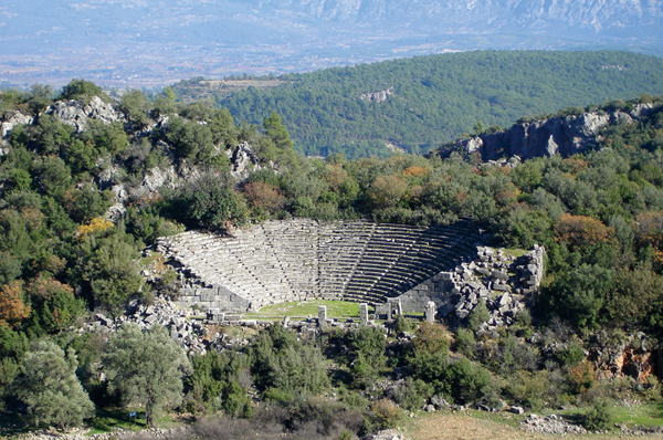
Ancient amphitheater in Pinara, Turkey, a site known to have been struck by earthquakes. Osmanyaylali, Creative Commons Attribution-ShareAlike 3.0 Unported
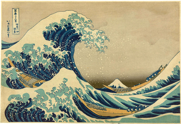
This famous Japanese color woodblock entitled "The Great Wave off Kanagawa," by Katsushika Hokusai (1760-1849), depicts a large tsunami wave with Mt. Fuji in the background. Library of Congress
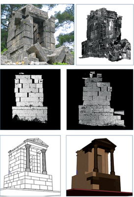
Multiple views of a Roman mausoleum in Pinara, Turkey, show how 3-D laser models are used to test different destructive scenarios like earthquakes and rockfalls. The damage to this structure is most consistent with a large earthquake. Klaus-G. Hinzen
The eyewitness accounts, written in columns from right to left, top to bottom, testify that there was no warning of the tsunami, no shaking to drive villagers to high ground before the wave hit, drowning rice paddies and swamping a castle moat. The entries, written by merchants, peasants and samurai, all clearly mark the time and date: just after midnight on Wednesday, Jan. 27, 1700.
For centuries, it was unclear why no shaking preceded the Japanese tsunami of 1700. Now, researchers know that it’s because the tsunami was set off by an earthquake clear across the Pacific. By noting the height of the waves described in the accounts and working backward from the moment the tsunami struck, modern-day researchers detailed the magnitude and timing of the causative event: a massive magnitude-9.0 earthquake that demolished villages along North America’s Pacific Northwest coast about 9 p.m. on Tuesday, Jan. 26, 1700.
Paleoseismic and dendrochronology studies along the Pacific Northwest coastline have corroborated the stories of the Japanese citizens. Centuries later, their remarkably accurate accounts serve as a sobering forewarning of the Cascadia Subduction Zone’s potential to produce another massive earthquake.
Knowing when a fault’s last major rupture occurred can tell geoscientists a lot about a region’s level of risk for the next Big One. But seismometers — instruments that record ground motion — have only been around for about 100 years, so scientists seeking information about older earthquakes often have to get creative.
Paleoseismologists have long looked to the rocks themselves for evidence of earthquakes. Evidence for ancient earthquakes can also be found throughout the annals of human history: old diaries and newspaper articles, folklore and legends, old photographs and ancient petroglyphs.
In recent years, ancient ruins have also become important sources for information. Long after written records have been lost and stories have faded away, crumpled buildings and toppled monuments still serve as mute witnesses to past earthquakes. Over the last 15 years, a field now known as archaeoseismology — or earthquake archaeology — has begun to take shape as researchers comb ancient sites in earthquake-prone areas for clues of past seismic events.
“People have tried to use damaged structures to study earthquakes for a long time, since the early days of seismology,” says Klaus-G. Hinzen, a geophysicist at the University of Cologne in Germany. The first attempts at using crumpled archaeological sites to study past earthquakes took place in the late 19th century, mostly in Rome, Italy. These early investigations were dominated by qualitative descriptions of damage and common sense arguments for or against seismogenic causes, Hinzen says.
The results were not always very robust, says Tina Niemi, a geologist and archaeoseismologist at the University of Missouri in Kansas City. “Earthquakes have been used and misused in the past to explain all sorts of catastrophes,” she says. “We’re trying to put the field back on more scientific footing.”
Only in recent years has the field of archaeoseismology begun to take a more quantitative tack, but damages to buildings and monuments are still proving difficult to unravel, Hinzen says. “Quantitative data are hard to come by, and what you do get can often be frustratingly vague,” he says.
The first challenge in archaeoseismology involves discerning whether structures collapsed during earthquakes or as a result of vandalism or internal failure. “There are many reasons why buildings fall down,” Niemi says. So researchers are trying to establish a set of criteria for identifying when ruins are the result of ground shaking or another destructive event, she notes.
The best results and most robust data usually come when archaeologists work directly with geoscientists, seismologists and engineers during excavations, Niemi says. “Sometimes it’s hard to all speak the same language, but we’re improving all the time.”
In addition to joining forces, the next step has been to start modeling. Hinzen and colleagues have pioneered the use of sophisticated lasers to create exact computer models of sites across Central Europe and the Mediterranean. One such site is a Roman mausoleum in Pinara, Turkey, that dates to approximately 700 B.C. The mausoleum is still standing, but its blocks have been rattled out of place.
“Archaeoseismology often deals with objects that are completely toppled,” Hinzen says. Once a structure is lying on the ground, the most scientists can hope to learn is the minimum amount of ground shaking needed for it to collapse. “You don’t know [by how much] that threshold was exceeded,” he says. “You only have the minimum needed to topple something.” A structure that is still standing but is deformed, like the mausoleum, provides an opportunity to constrain the low and high levels of shaking, Hinzen says.
To determine whether the rectangular blocks of the mausoleum were rattled by an earthquake or a rockfall — the site sits below a cliff and several large boulders are strewn about — Hinzen and colleagues used a 3-D laser scanner to map 11.5 million points of the structure and create a finely detailed 3-D image.
Then, Hinzen plugged different shaking scenarios into a computer model, both from earthquakes and boulder impacts of various sizes, and found that the deformation of the mausoleum could only be reproduced by significant ground shaking — larger than could be produced by a rockfall. The next step, he says, will be to try to constrain the upper and lower magnitudes of an earthquake that would have shifted the mausoleum’s blocks but not caused it to fall down.
Other types of ruins can also reveal different information about past earthquakes. Fallen columns, for example, can potentially be used to estimate the strength and direction of ground motion, thereby attributing movement to a particular fault. “One fallen column doesn’t tell you anything,” Hinzen says. “But many of these sites have dozens of columns, all toppled in the same direction, which might tell you something about how the ground was moving.”
By creating digital models of the two most common types of columns — monolithic columns composed of one solid piece of stone and multiblock columns made up of stacked cylinders — and plugging in different types of ground motion generated by real earthquakes, Hinzen has been able to closely define the degree of motion necessary to topple each. But pinpointing which of the different types of ground motions may have toppled the columns, and therefore the source direction of the earthquake, has proven more challenging. During an earthquake, ground motions can be quite complex, occurring in three dimensions and oscillating in different waveforms. “For example, we don’t know if the initial P-waves toppled the column or the later shear waves,” Hinzen says. The P-wave would likely topple the column parallel to the direction of wave propagation while the shear wave would cause it to fall transversely, making it difficult to determine from which direction the fault rupture likely occurred.
Lacking exact magnitudes or dates of past earthquakes, such limited results are typical of archaeoseismology studies, says Susan Hough, a geophysicist at the U.S. Geological Survey in Pasadena, Calif. “Archaeoseismology usually only gives you little pieces to the overall puzzle,” she says. “The field is strongest when it’s very crossdisciplinary and you can consult other sources — like written records or archaeological evidence — for more specific information.” Hough has studied past earthquakes in Pakistan using old photographs, which provide some of the only information about earthquake history in the Kashmir Valley region. Written records from the region are scarce, she says, likely due to long periods of unrest brought on by fighting between India and Pakistan.
The area is no stranger to earthquakes. In October 2005, the Kashmir region of Pakistan was struck by a magnitude-7.6 temblor that killed more than 80,000 people. The event was not a total surprise to geologists, as paleoseismic evidence indicated that the region had been rocked by a similarly large quake in 1555 and by a series of smaller events in the 1800s.
A historic photograph of the Shiva Temple in Pandrethan, built in A.D. 920, was thought to be evidence of a known quake in 1885, Hough said, until an even older photograph of the same temple was discovered that showed the same extent of damage already in place in 1863. The photos led Hough and her colleagues to conclude that the 1885 earthquake must not have been as strong as the earlier event, given that it caused no further damage to the temple.
“Considering the fragility of the structure, we concluded that Pandrethan has not experienced European Macroseismic Scale intensity greater than VIII in the past 200 years and possibly not in the past millennium,” Hough and colleagues wrote in a 2010 GSA Special Paper. (European Macroseismic Scale, or EMS, intensities are not based on seismic energy, but on the degree of damage. An EMS intensity of VIII is heavily damaging; the EMS scale goes up to XII, which signifies complete devastation.)
“Of course, that’s not a huge amount of information, but it’s something,” she says.
Written accounts of earthquakes, dating back thousands of years in some parts of the world, often prove to be the most helpful sources of information. In China, for example, the earliest records from Shandong Province in the northeastern part of the country date to 1831 B.C., and fairly complete records of Chinese quakes exist from the Zhou Dynasty, starting in 780 B.C. Although China has a long tradition of carefully written earthquake records, most regions do not. North and South American civilizations lacked strong writing traditions, while civilizations in Europe and the Middle East experienced long eras of unrest, during which records were lost or destroyed. That’s where folklore and legends come in.
Some of the more enduring sources for evidence of ancient earthquakes involve tales invented by people trying to explain natural phenomena. According to Japanese mythology, for example, earthquakes were caused by a monster catfish known as Namazu that lived under the islands of Japan. Most of the time, the fish was restrained under a rock by a god, but when the god was distracted, Namazu would thrash about, making the Earth tremble.
Other, more factual stories can sometimes reveal information about the time, place and size of ancient earthquakes. Perhaps some of the most well-known and most historically accurate earthquake folklore comes from the Pacific Northwest. Just a few decades ago, before Japanese records of the 1700 tsunami had been discovered, the Pacific Northwest was thought to be fairly seismically inactive compared to the rest of the West Coast. Now, it is considered one of the most potentially hazardous earthquake zones in the world.
“In the 1980s, rumors began spreading through the geoscience community that a very large earthquake could have struck the Pacific Northwest in the past, but we only had bits and pieces of evidence,” says Ruth Ludwin, a seismologist at the University of Washington. “That’s when I began wondering what the native people might know about [this region’s] earthquake history.”
Europeans settled on the Pacific Coast in the late 1700s, but the first newspapers were not published until the 1850s. Several accounts of earthquakes and tsunamis are recorded in these newspapers, but Ludwin hoped native folklore could take the record back much further. “Some of these tribes have lived on this coast for thousands of years,” she says.
Tribal scholars estimate that up to 90 percent of native folklore in the Pacific Northwest has been gradually lost due to a decline in oral storytelling traditions, but Ludwin found a wealth of information in written accounts and audio recordings made by anthropologists in the early 1900s. Many featured references to earthquakes, landslides and tsunamis.
One of the most pervasive stories, found in folklore from Vancouver, British Columbia, to Northern California, was that of the thunderbird and the whale. The story had many variations, but all contained references to earthquakes and tsunamis. One account reads: “My father told me that when the thunderbird battled the whale there would be shaking and a jumping of the Earth and a rolling up of the great waters.”
“There is definitely something historic about these stories,” Ludwin says. “This is clearly not just a mythic event. It’s a warning.”
Some of the most vivid earthquake and tsunami accounts came from the western coastline of Vancouver Island, where tsunami waves produced by the magnitude-9.2 Great Alaskan Earthquake of 1964 were funneled far inland by narrow river inlets. “The geography of this particular coastline makes communities very susceptible to tsunamis,” Ludwin notes. “So it’s not surprising they’d have such a strong oral tradition of tsunami stories.”
By counting backward through the generations — many stories begin with “my great grandfather told me” or something similar — Ludwin has been able to date many of the thunderbird and whale and other earthquake legends to the 1700 quake and earlier. “It’s clear from these stories that earthquakes and tsunamis are cyclical events that happen over and over again on this coast,” she says.
Piecing together the seismic history of active fault lines is an important step in establishing future hazard maps, and evidence preserved in ancient ruins and old folklore in particular adds a human element that may aid in averting high death tolls in the future.
“Folklore puts people in the picture,” says Brian Atwater, a geologist at the University of Washington. “It really adds an intriguing human dimension to earthquake research,” which could prove valuable in educating the public about the potential risks associated with future events.
On the coast of Northern California, tribal stories have already helped the town of Orick, home of Redwoods National Park, assess and plan for future tsunami risks. Stories passed down by the native Yurok people mention specific landmarks inundated by seawater after the Cascadia earthquake of 1700. In 2007, the town developed a tsunami evacuation plan based on these landmarks and earned TsunamiReady certification through a program started in 2001 by NOAA and the National Weather Service to increase tsunami awareness and encourage preparedness in vulnerable coastal communities.
“Newer communities along the coast that don’t have an ancestral history of the destructive power of earthquakes and tsunamis can learn a lot from tribal traditions,” Ludwin says. “These stories should make believers out of all of us.”
Two of the most challenging barriers to studying ancient earthquakes using less conventional methods, like archaeoseismology, have been securing funding and finding appropriate places to publish new studies. “Archaeoseismology can be a problem because it doesn’t fit neatly anywhere,” Hough says.
Some funding has come from UNESCO’s International Geoscience Programme, which has funded Niemi’s work in the Alpine-Himalaya zone, among other archaeoseismology projects. Funding for folklore studies of past earthquakes has been even more difficult to come by, Hough says.
In 2007, the Geological Society of London released a Special Publication on Myth and Geology, which provided a much-needed venue for myth- and folklore-based studies, but by and large, too many potentially fruitful studies are going unfunded or unnoticed, Hough says.
“Archaeoseismology does tend to give us only little puzzle pieces, but they’re often the only pieces we get,” she says. In some cases, however, as with the Cascadia earthquake and tsunami of 1700, looking outside the rocks can lead to some very big discoveries.
© 2008-2021. All rights reserved. Any copying, redistribution or retransmission of any of the contents of this service without the expressed written permission of the American Geosciences Institute is expressly prohibited. Click here for all copyright requests.