
by Erin Wayman Thursday, January 5, 2012
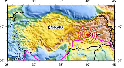
The magnitude-6.0 earthquake hit eastern Turkey on the East Anatolian Fault. U.S. Geological Survey
A magnitude-6.0 earthquake struck eastern Turkey at 4:32 a.m. local time Monday. The quake was centered in Elazig province about 625 kilometers east of Turkey’s capital, Ankara. The earthquake toppled buildings, flattened homes, injured at least 100 people and killed 57, according to the Associated Press.
Turkey is no stranger to seismic activity. The country lies near the collision of the Arabian and Eurasian plates. It also sits on the Anatolian Block, a large section of continental crust between the Arabian and Eurasian plates that is moving westward at a rate of 24 millimeters per year. The block is bordered by the North Anatolian Fault to the north and the East Anatolian Fault to the southeast.
The magnitude-6.0 earthquake, which struck at a depth of 10 kilometers, was likely due to a rupture on the eastern end of the East Anatolian Fault, says Don Blakeman, a geophysicist at the U.S. Geological Survey’s (USGS) National Earthquake Information Center in Golden, Colo. It’s similar to a magnitude-6.4 earthquake that struck eastern Turkey in 2003, Blakeman says. That quake killed 150 people and injured at least 1,000, according to USGS.
The North Anatolian Fault has been home to a series of strong earthquakes since 1939. The most recent event was a magnitude-7.6 quake that hit the city of Izmit. Each successive earthquake has occurred farther west than its predecessor, and scientists warn that Istanbul, Turkey’s largest city, may be the next target in this string of powerful quakes — or it may not, according to new research.\
© 2008-2021. All rights reserved. Any copying, redistribution or retransmission of any of the contents of this service without the expressed written permission of the American Geosciences Institute is expressly prohibited. Click here for all copyright requests.