
by Sarah Derouin Monday, March 19, 2018
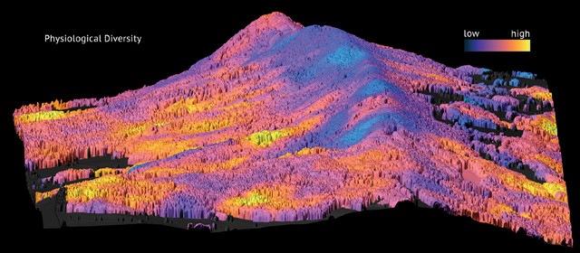
Researchers used airborne imaging and spectroscopic techniques to study the diversity of forests in Switzerland's Laegern Mountains. Credit: UZH.
Traditional surveys of forest health and diversity take hours of hiking and sampling by scientists who can only cover relatively small areas. Satellites, meanwhile, can survey large swaths of land, collecting information about forests in a fraction of the time that a ground survey might take. But the resolution and types of satellite data available don’t always allow for detailed studies. Now, a team of ecologists is staking out the middle ground by developing airborne laser scanning techniques to create high-resolution maps of tree species diversity to monitor changes in forest ecosystems.
A more diverse forest “can be more productive and stable over longer timescales than a less diverse forest, especially under changing environmental conditions,” says Fabian Schneider, a doctoral student studying geography at the University of Zurich in Switzerland and lead author of a new study in Nature Communications. Schneider and his colleagues focused on a 2-by-6-kilometer area of temperate mixed forest in Switzerland’s Laegern Mountains. The team used airborne lidar and imaging spectroscopy to measure three morphological characteristics (canopy height, plant area index and foliage height diversity) and three physiological traits (leaf chlorophyll, carotenoid and water content) related to forest diversity and health.
Morphologically diverse collections of trees — with different heights and shapes, for example — allow light to spread through the canopy, benefiting the entire ecosystem. Lidar measurements of the morphological traits of the forest offered indications of how well trees were growing and, as a result, how efficiently they took up carbon.
By measuring light reflected by leaves using spectroscopy, the team quantified physiological traits of leaves related to pigment and water content. The researchers then verified their airborne observations with on-the-ground field surveys. After validating their results, they used their data to model patterns in diversity and ecosystem health. The researchers found a strong connection between forest diversity and location, with soil and topography playing an important role: For example, lower diversity of trees occurred along a ridge, where conditions are drier and soils are shallower and rockier than elsewhere.
The approach developed in the new research is scalable, Schneider says, and can be used to study forest ecosystems at multiple scales, from groves down to solitary trees.
“Remote sensing technologies are useful in guiding conservation efforts, ecosystem management and resource policy,” says Gregory Asner, a conservation scientist at the Carnegie Airborne Observatory and Stanford University who did not participate in the new research.
Currently, Asner says, “the technologies that allow us to do functional mapping of forests, and vegetation in general, are only available [for use] on aircraft,” but he and other researchers hope they’ll eventually be available on satellites so researchers can look at larger portions of the planet. Satellite monitoring is critical to study changes in Earth’s biosphere amid a changing climate, he says.
© 2008-2021. All rights reserved. Any copying, redistribution or retransmission of any of the contents of this service without the expressed written permission of the American Geosciences Institute is expressly prohibited. Click here for all copyright requests.