
by Chris Goldfinger, Yasutaka Ikeda and Robert S. Yeats Monday, December 3, 2012
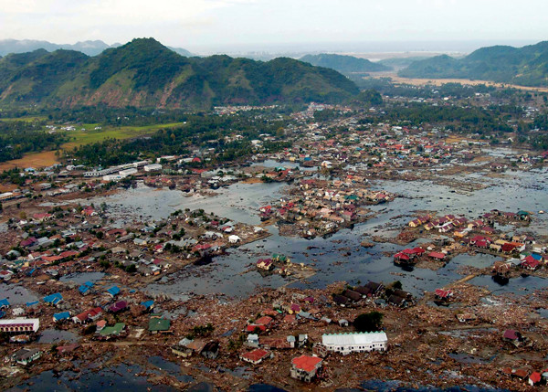
A village near the coast of Sumatra after the tsunami that struck Southeast Asia the day after Christmas 2004. U.S. Navy photo by Photographer's Mate 2nd Class Philip A. McDaniel
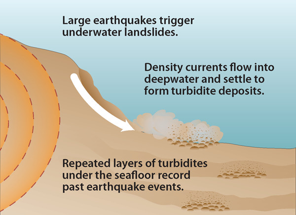
Scientists can use turbidites (submarine slope failure deposits) collected from the ocean floor to understand past earthquakes. Turbidites provide clues to the timing and magnitude of past events. The authors have collected turbidites from 6,000 meters below the sea surface off the coast of Sumatra and 3,000 meters deep in the Cascadia Subduction Zone in the Pacific Northwest. Kathleen Cantner, AGI
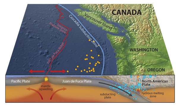
The historic seismic record from the Cascadia Subduction Zone is no longer limited to instrumental earthquake data (blue dots). It has been extended by the association of mega earthquakes with turbidite deposits identified in offshore sediment cores (orange dots). Kathleen Cantner, AGI
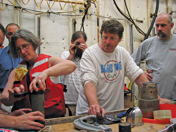
The Oregon State University coring team examines the upper section of a turbidite core recovered off the Sumatran margin. Chris Aikenhead
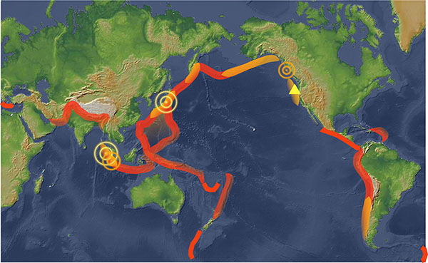
Recent surprising earthquakes in Japan, Sumatra and the Queen Charlotte Islands (circles), as well as new research along the Cascadia Subduction Zone (triangle), indicate that most any fault zone could rupture significantly. Locations that have previously experienced "superquakes" are shown in yellow. Locations that researchers are starting to think could potentially experience magnitude-9 quakes are shown in red. Kathleen Cantner, AGI
A number of recent big earthquakes around the world have humbled many earthquake researchers. The March 2011 magnitude-9 superquake off Tohoku, Japan, and the December 2004 magnitude-9-plus temblor off Sumatra were both far larger than what scientists expected those fault systems to produce. Based on these quakes, and on recent research that contradicts long-held paradigms, it is becoming clear that the types and sizes of large earthquakes that a given fault system is capable of producing remain poorly known for most major fault systems.
The problem is that we are relying on short historical records, and even shorter instrumental records. Basing estimations of maximum earthquake size or models of earthquake recurrence on such records or on the behavior of smaller earthquakes does not encompass the full range of fault behavior. We can no longer hold onto the notion that magnitude-9 earthquakes might be likely to occur in some areas, but not in others. So much remains to be learned about great earthquakes
There are a few places with long and detailed enough records to examine long-term behavior of major fault systems: Northeastern Japan and Cascadia, off the coast of Oregon, Washington and British Columbia, are two of the best-studied. And thanks to new research techniques, those two areas are offering new lessons and hints at earthquakes to come.
Scientists have developed detailed conceptual models of quake behavior and recurrence rates. We have the characteristic earthquake model, which suggests that faults have “typical” repeatable ruptures. We also have the seismic gap theory, which suggests we should look to holes in the instrumental record for future events. We have relied on a theory that plate age and convergence velocity determine maximum earthquake size. And we have tried to apply recurrence rate models, based on the relationships between time before or after an earthquake, to inform us about the next earthquake. But all of these models are built on the short instrumental and sometimes historical records.
As we begin to gather more long records from around the world, we are beginning to see more complex behavior. Strain may accumulate at even very slow rates, sometimes in settings previously considered unlikely, eventually to be released in very large earthquakes. Such long-term cycling is suggested for Cascadia, Hokkaido, northeastern Japan, Chile and Sumatra.
In the case of northeastern Japan, earthquakes of the past few hundred years had dimmed the memory of the Jogan superquake of A.D. 869, which produced a tsunami that killed about 1,000 people on the Sendai Plain and was probably similar in size to the Tohoku quake. Models were largely based on more recent quakes.
In Cascadia, models showing a limited range of expected quake sizes have been based on excellent but relatively short paleoseismic records onshore. However, recent research on undersea deposits indicates that a wide range of earthquake sizes has occurred there, including quakes larger than previously thought possible and smaller ones limited to southern Cascadia. In Sumatra, models suggest that plate convergence was so oblique that the plates were moving parallel to each other, and that a subduction-type earthquake like the one that occurred in 2004 was unlikely.
In general, relationships — such as that between plate age and convergence rate — were appealing but had never really been tested. They were based on dubious physical concepts and the short instrumental record. These modeled relationships were on shaky ground in terms of both statistics and the unknown nature of long-term energy storage and release in subduction zones.
Scientists are now working to rewrite these models based on new evidence.
There are a couple of ways to look at the seismic hazard in northeastern Japan, near where the Tohoku quake struck. Using the historical record, especially of the most recent earthquakes in the Sendai area — a magnitude 8.4 in 1933, a magnitude 7.1 in 1936, and a magnitude 7.6 in 1978 — most scientists considered the largest likely quake in the region to be about 8.4. Those earlier quakes did not leave widespread tsunami records. More numerous and perhaps better remembered are the smaller events in recent decades and centuries that make up the majority of the historical record; it was these smaller events that drove the underestimation of the seismic and tsunami hazard in northeastern Japan.
The historical record can be helpful, however, if you look far enough back in time; and if you include paleoseismic and paleotsunami evidence, the picture changes. The older historical record in the Tohoku region, for example, reveals a number of large earthquakes and associated tsunamis, including large events in A.D. 869, 1611 and 1896. The largest of these events was the A.D. 869 Jogan tsunami, based on the presence of tsunami deposits in a coastal lake and across the Sendai and Ishinomaki plains. The landward inundation of the March 2011 tsunami penetrated 3.5 to 4 kilometers inland on the Sendai Plain, similar to the Jogan tsunami (although at the time of the Jogan event, the shoreline was approximately 1 kilometer inland of where it presently is). The paleotsunami evidence also includes two predecessors to the Jogan event, which also penetrated approximately 4 kilometers inland. That evidence supports the existence of “outsized” events — those about magnitude 9 or so — along the Tohoku coast with recurrence times in the range of 800 to 1,200 years.
Looking at both long-term geology and new instrument-based research also provides a new view of the seismic hazard in this region. For at least the past 5 million years, the Japan arc has been subjected to east-west compression due to convergence of the Pacific Plate at a rate of 80 millimeters per year. Investigating the structural geology of northeastern Japan reveals that a fold-and-thrust belt permanently relieves some of this compression, but only at a rate of about approximately 3 to 5 millimeters per year. Including other active faults and folds, the total rate of permanent horizontal shortening over the Northeast Japan arc is about 5 to 7 millimeters per year. Permanent uplift of northeastern Japan occurs at a rate that is in agreement with the permanent shortening. This indicates that less than 10 percent of plate convergence is accommodated in the Japan arc as permanent deformation.
In the short term, however, triangulation, trilateration and GPS observations show that the Japan arc has been shortening at a rate as high as several tens of millimeters per year over the last century, much higher than geological rates. At the same time, abnormally high rates (up to 10 millimeters per year) of subsidence along the coast have been observed by tide gauges during the last 80 years or so. Despite the fact that marine terraces along the Pacific coast of northeastern Japan show permanent uplift, the best explanation is that in the short term, it is being dragged downward by the subducting Pacific Plate.
The difference between short-term and long-term deformation rates indicates that most of the plate convergence is not deforming northeastern Japan. Instead, that energy is elastic and is being stored in the way that a spring stores energy. Eventually, this energy must be released by slip on the subducting plate boundary as giant earthquakes. Yet in recent times, earthquakes with magnitudes of only 7 to 8.4 have occurred in the same region, and did not result in the release of very much of the accumulated energy. To release the excess energy and balance plate motion, much larger earthquakes must occur. Thus, the Tohoku magnitude-9 earthquake should not have been unexpected with longer-term information taken into consideration. Nonetheless, very few geologists accurately forecasted the size of the Tohoku earthquake.
In Hokkaido, north of Sendai, a similar relationship has been observed between the shorter historical and instrumental records and the paleoseismic record along the Kuril Trench. Prehistoric tsunamis that most likely were generated from long ruptures along the Kuril Trench were significantly larger than those existing in the historical and instrumental records. Over the past 2,000 to 7,000 years, such outsized events occurred on average about every 500 years, with the most recent event approximately 350 years ago.
The best-known large earthquake along the Cascadia Subduction Zone occurred in 1700. The magnitude of the earthquake is estimated to be approximately 9, based on the arrival of an “orphan tsunami” — meaning there is a tsunami record without a corresponding local earthquake — along the Japanese coast. The perception of Cascadia quickly underwent a paradigm shift, from a place thought to host no earthquakes at all to a region capable of great earthquakes, based largely on this quake. More recently, the view of Cascadia’s hazard has been changing again due to new paleoseismic work.
Because there haven’t been any large quakes along Cascadia in recent history, the entire earthquake record is based on several decades of paleoseismic work. New evidence from onshore subsidence and tsunami deposits and offshore turbidites (submarine slope failure records) has yielded an unprecedented record of great earthquakes along the Cascadia Subduction Zone. The offshore records are in good agreement with onshore paleoseismology evidence, and both offer consistent information about the relative size of paleoearthquakes, lending confidence that both are recording the same phenomena. The longest records available, those from deep-sea turbidites, reveal information about much longer-term behavior of this subduction zone going back 10,000 years.
In 1999, we started looking at turbidite deposits along the Cascadia margin to see what they could tell us about ancient earthquakes. Canadian geologist John Adams had proposed in 1990 that turbidite deposits first discovered along the Cascadia margin in the 1960s reliably recorded 13 past great earthquakes. We thought otherwise, and collected numerous cores from Canada to Northern California to test the idea. It turned out that we were wrong, and a decade of work and three coring cruises have led to a detailed earthquake record along the 1,000-kilometer length of Cascadia. We now have a 10,000-year integrated onshore-offshore earthquake record in Cascadia, including 41 probable earthquakes. This long record allows us to look more deeply into how this great fault behaves over long periods of time. One thing that is obvious is that the turbidites show an apparent clustering of great earthquakes into groups of four to five events, with 700- to 1,000-year gaps between the clusters. The turbidites also provide clues to the magnitudes of past events, and to the buildup and release of energy over time.
In the turbidite record, the benchmark 1700 earthquake is roughly average relative to 19 similar ruptures, in terms of turbidite thickness and mass over the past 10,000 years. About a half dozen turbidites are larger than the 1700 event and a half dozen smaller; the rest are similar. Two obviously larger events are the 11th and 16th events back in time, at about 5,960 and 8,810 years ago. These turbidites are consistently two to five times larger than “average” turbidites at all core sites along the length of Cascadia, and may have been triggered by a magnitude-9.1 quake, which is 44 percent larger than a magnitude-9 quake.
Our research shows that, despite the obvious simplifications involved, a connection between turbidite mass and energy release of the source earthquakes can be made because of consistency in the turbidite records along the length of the margin at multiple sites and multiple depositional environments. We also found a good correlation between turbidite size and tsunami size at Bradley Lake along the southern Oregon coast, where an excellent 4,600-year tsunami record is found. This suggests that when paleoseismic records are long enough and of sufficient quality, we may be able to tease out more information about past earthquakes than just their timing.
We have also done further research on long-term patterns, looking at the energy balance between the Juan de Fuca and North American plates in Cascadia. Because the turbidite size is so consistent among sites, the size of the turbidites can be used as a crude measure of energy release and balanced against the energy gain from plate motion. Plotting the energy gain against energy loss, it is possible to generate a 10,000-year energy time series for Cascadia, showing how energy is stored and released by the fault over time.
What this plot and a similar one created for the Sumatran subduction zone show is that not only are earthquakes clustered in time, but there appears to be a long-term cycle of energy storage and release. The resulting sawtooth pattern reveals what we interpret as long-term energy cycling on the subduction zone, with some events releasing less energy and others releasing more energy than is generated from plate convergence alone. Earthquakes that are larger than the energy available from plate convergence may have “borrowed” stored energy from previous cycles; at other times, energy is stored when less energy is released than is available.
The plots also show that when a fault is in a high- or low-energy state, its behavior can vary. For example, when Cascadia (and perhaps other faults) is at a high-energy state, it appears equally likely to rupture in single very large (maybe magnitude-9.1) earthquake or in a series of somewhat smaller (but still giant) magnitude-8.8 to -9 earthquakes to relieve stress. When at a very low-energy state, Cascadia may go for long periods without any quakes, or it may shake in a series of earthquakes that only release a little of the accumulated energy over time — something that also clearly occurred for the 1,000 years prior to the 2011 Tohoku earthquake.
The plots also suggest that the size of an earthquake is not that closely related to the time since the last earthquake. Think of a battery as representing the energy storage of a plate boundary: You can draw energy from it in any increment available at any time, limited only by the total energy available.
What this means for Cascadia and other subduction zones is that we cannot say very much about the next earthquake based on the few most recent ones. Long paleoseismic records help get around this problem. Turbidites from deep water in subduction zones and from lakes offer ways to build these long records. They have the advantage of being able to link the records between sites with physical stratigraphy and extend them further back in time.
Where long paleoseismic records aren’t available, or in addition to paleoseismic evidence, scientists are frequently turning to geodetic data — data from GPS, strain gauges and tide gauges — to inform assessments of seismic hazards based on how the land is deforming in real time. We now have a wealth of geodetic data that directly provides strain accumulation and slip rates on faults. These geodetic rates are commonly thought to be the best available data.
In some cases, geodetic rates over the last few years agree with long-term rates determined from geology, such as slip rates on faults and uplift rates of mountains; at other times, geodetic rates undershoot or overshoot these geologic rates. The reasons for the differences are not always clear, but given the examples of very long-term cycling of earthquake energy release, it’s likely that one cause for the discrepancy in rates is linked to the short time frame of the observations.
Not only are the geodetic observations made at random times in the seismic cycle of nearby faults, they may well also be at random times in a long-term multi-event “supercycle,” making the data less directly linked to average plate and fault block motions, and more difficult to interpret in terms of size and rates of future earthquakes.
With short records, almost every significant earthquake is “new” to geologists. The magnitude-7.7 quake last October in the Queen Charlotte Islands off British Columbia was a thrust earthquake, a type not seen previously on that strike-slip fault, and the magnitude-8.6 strike-slip quake off the coast of Sumatra last April was the largest of its type ever recorded.
Another issue with short observation periods is the question of global clustering. Many people have noted that we have had a lot of really large earthquakes lately. Tohoku in 2011, Chile in 2010, Sumatra in 2004. Before that, there is a gap of 50 years following the 1964 Alaskan earthquake, with several other giants clustered between 1957 and 1964. These great earthquakes are clearly clustered in time, but is this just a random phenomenon, or does it mean something about global plate dynamics?
A couple of recent studies suggest global clustering of magnitude-9 earthquakes doesn’t exist, and can easily be explained as part of a random process. The problem, though, is that because the recurrence times of magnitude-9 earthquakes can be hundreds of years, and for the largest events can be 5,000 to 6,000 years, we mostly don’t have enough data to actually test this idea either way. Absent enough magnitude-9 events, smaller earthquakes with higher frequencies from other fault systems are used as proxies, but the comparison is dubious at best.
The observation that magnitude-9 events worldwide have clustered twice in the last 100 years is also questionable because no mechanism to produce such clusters is known (of course, observations virtually always exist before explanations are found). It’s likely that this question will remain open for the foreseeable future, until we have long records from enough subduction zones to examine whether this phenomenon really exists, and if so, what it might mean and what mechanism could explain it.
So, where will the next big one be? That’s impossible to say. But the recent surprises from Tohoku and Sumatra, coupled with new evidence of long-term seismic supercycles on faults like Cascadia and Sumatra, imply that other subduction zones and other major fault systems may be capable of massive quakes.
Based on older models, relatively old subduction plate systems have been ignored as potential producers of magnitude-9 earthquakes, but recent quakes show these zones are indeed at risk. Such areas include much of the west coast of South America, the remainder of the Japan Trench, the Himalayan Front, the Kuril Islands and the western Aleutians in the North Pacific, Java, Indonesia, in the South Pacific, the Antilles Islands in the Caribbean, the Makran coastal area in Iran and Pakistan, and the Manila, Sulu, Philippine and Hikurangi trenches, among many others.
Finally, the underlying cause of supercycles is unclear. They could be generated by intrinsic properties of the plate boundaries, cycling of energy among segments of an individual fault, transfer of energy between adjacent faults, or even energy transfer acting over larger distances. In addition, there is clear evidence of global clustering of magnitude-9 earthquakes, but we don’t have long enough records from around the world to say for sure whether this phenomenon is real or random, or what it means.
The earthquake community has had to take a step back and abandon older models of great earthquake occurrence. Today it’s not clear whether new global models will emerge, or whether local geology has the final say and that there are no universal governing relationships to guide model-based hazard assessments. In either case, hazards can be addressed directly by gathering long earthquake records that don’t depend on models. Such records can answer the societal hazard questions in a straightforward way long before there is consensus on global plate dynamics.
© 2008-2021. All rights reserved. Any copying, redistribution or retransmission of any of the contents of this service without the expressed written permission of the American Geosciences Institute is expressly prohibited. Click here for all copyright requests.