
by Timothy Oleson Wednesday, May 9, 2012
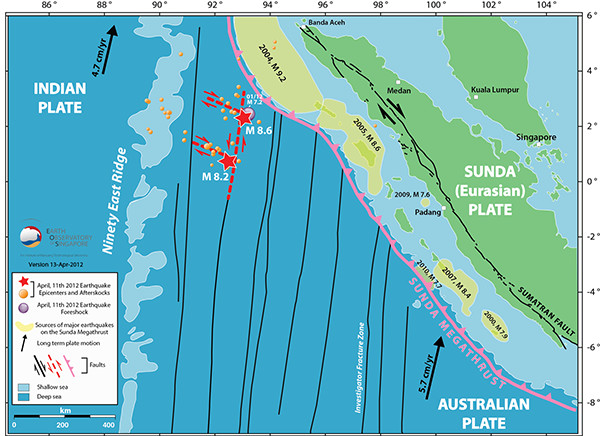
Map showing the location of two large strike-slip earthquakes (red stars) off the west coast of Sumatra, Indonesia on April 11, 2012. Aftershocks (orange circles) of the strike-slip earthquakes are also indicated, as are prominent tectonic features including the Sunda megathrust fault (pink) and a series of north-south fractures (black) in the vicinity of the earthquakes. courtesy of Earth Observatory of Singapore
Following the magnitude-8.6 earthquake that struck off the coast of Sumatra, Indonesia on April 11, chaos reigned in Banda Aceh, a provincial capital near Sumatra’s northern tip as residents scrambled to evacuate to higher ground ahead of a potential tsunami. Unlike in December 2004 when a deadly tsunami — triggered by the magnitude-9.1 Sumatra-Andaman earthquake — swept over the Sumatran coastline, though, no significant tsunamis made landfall on April 11 and only a handful of earthquake-related fatalities were reported.
Scientists quickly identified why no tsunami had followed either the main shock or the magnitude-8.2 aftershock that hit two hours later: The earthquakes had occurred on strike-slip faults more than 400 kilometers offshore rather than on the Sunda megathrust fault that traces Indonesia’s western coast and that has been responsible for a series of large earthquakes since 2004. Whereas thrust faults experience vertical motion that can displace overlying water and produce tsunamis, movement on strike-slip faults is predominantly horizontal — with portions of tectonic plates grinding laterally past one another — and does not typically cause tsunamis.
For all that can be explained, however, the April 11 earthquakes took most scientists by surprise. The combination of their size — the magnitude-8.6 main shock is by most accounts the largest strike-slip earthquake ever recorded — and their location in the middle of the oceanic Indo-Australian Plate is challenging the paradigm of strike-slip earthquakes and is raising new questions about the region’s tectonics.
All of these large recent earthquakes “continue to surprise us … Every new earthquake breaks some rule we thought we had,” says Heather DeShon, a seismologist at the University of Memphis. “This one broke the rule that a strike-slip earthquake isn’t going to get much bigger than a magnitude-8.0.” Earthquake magnitudes, or moments, scale with the area over which a fault ruptures, which explains why earthquakes on long subduction zones — where one tectonic plate plummets back into the mantle beneath another, creating a broad area of contact between the two — can be so large. In contrast, DeShon says, strike-slip systems tend to be limited to shallower depths and to “bend around and undulate,” which “breaks the fault into smaller pieces.”
Examples of strike-slip earthquakes in oceanic intraplate settings are rare but have been documented — including in the Wharton Basin near where the April 11 quakes occurred — but the size of the recent events makes them unique. Preliminary studies by the U.S. Geological Survey (USGS) and others suggest that as much as 50 meters of movement, or slip, occurred near the epicenter of the main shock. Large strike-slip events typically produce less than 10 meters of slip, says Paul Tapponnier, a tectonophysicist at the Earth Observatory of Singapore, “so it’s clear that these earthquakes are exceptional.” Maximum slip along the San Andreas Fault from the magnitude-7.9 earthquake that devastated San Francisco in 1906 was between 6 and 9 meters, according to USGS.
The massive amount of slip does not fully explain the large magnitude of the April 11 earthquakes, however, particularly in a thin oceanic plate where the crust is only about 5 kilometers thick. Considering the large moments, Tapponnier says, the quakes were likely nucleated in the uppermost, or lithospheric, portion of the mantle — perhaps as deep as 25 or 30 kilometers — before propagating upward through the overlying oceanic crust. Because the lithospheric mantle has more mechanical strength than the crust, he says, “we think that part of the large moment is related to the fact that … you can keep much higher stresses for longer in the mantle.”
Another apparent reason for the large magnitude, says Miaki Ishii, a sesimologist at Harvard University, is that multiple faults appear to have slipped almost simultaneously, creating a composite earthquake. “If it was just a single fault activation, it wouldn’t have been large as 8.6. We see this sort of fault activation — a cascading failure of faults, basically — in all sorts of large earthquakes,” she says. But determining exactly which faults might have ruptured has proved challenging so far.
Identifying rupture planes on exposed continental strike-slip faults, like the San Andreas, or on transform faults at mid-ocean ridges is typically straightforward. “We know exactly what sort of motion we should expect there,” Ishii says, but “this earthquake happened out in the middle of nowhere.” So, she says, “our initial guess was to go with the local seafloor fabric,” which in this case is mainly characterized by a series of north-south trending transform faults and fractures left over from the Eocene-aged Wharton spreading center.
The main shock and the magnitude-8.2 aftershock were indeed aligned along one such fracture and early analyses of seismic data suggested that this was the likely culprit. But subsequent examination of the aftershock sequence showed that many were actually aligned perpendicular to the north-south fractures, indicating that faults along both orientations may have been triggered. “The aftershocks are showing us something very different from our … current understanding of that region, so that’s why it’s extremely confusing,” Ishii says.
A clearer picture of the faults that ruptured, as well as an understanding of how the oceanic lithosphere could have accommodated such large stress before breaking, will require further research. But perhaps even more interesting is the question of what caused these faults to rupture when and where they did.
Seismologists suspect that two prominent tectonic features might have contributed. The earthquakes occurred in the middle of a so-called diffuse zone that separates the northern and southern portions of the Indo-Australian Plate, which are slowly shearing apart from one another as they move northeast at different rates, causing occasional seismic activity. The recent earthquakes will shed light on this “mysterious” boundary, Tapponnier says. “Why is it diffuse? Why doesn’t it localize? In fact, why is it not a real plate boundary?” But as far as the timing of the recent strike-slip earthquakes, “clearly the temptation, and the logic, is to relate them to the big, ongoing Sumatran megathrust sequence.” When those earthquakes occurred, he says, some of the friction that was holding the Indo-Australian Plate back was suddenly released, allowing it to lurch forward but also pulling and increasing tension on portions of the plate to the southwest of the subduction zone.
The next question is how the large strike-slip earthquakes might in turn alter the stress in the subduction zone “because it’s a sort of back-and-forth interaction," Tapponnier says. "You have nuts and bolts that suddenly break, and you have to figure out where is the next weakest place that might go.” Of most concern is a patch of the megathtrust fault off the coast of Padang, a low-lying city of more than 800,000 on the west coast of Sumatra, which has not ruptured since 1797. “This whole place is alive,” Tapponnier says. “It’s both a very exciting problem for us scientists, but it’s also a very worrying situation for local populations.”
© 2008-2021. All rights reserved. Any copying, redistribution or retransmission of any of the contents of this service without the expressed written permission of the American Geosciences Institute is expressly prohibited. Click here for all copyright requests.