
by Brian S. John and Lionel E. Jackson Jr. Thursday, January 5, 2012
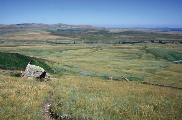
Glacial eratics in Canada, such as this giant boulder on the Alberta plains, exemplify how glaciers could have carried giant boulders from mountains in Wales and deposited them on Salisbury Plain. Lionel Jackson
Glaciers once carried giant boulders out of the Canadian Rocky Mountains and moved them hundreds of kilometers southward. Graham Colson
Glaciers carried giant boulders out of the Canadian Rocky Mountains for hundreds of kilometers. Brian John and Lionel Jackson
A tale of glaciers, man, rocks and North America
Out of the mist that blankets the gently rolling hills of Salisbury Plain, Stonehenge rises above the horizon like a haunting beacon. Whatever its original purpose, one thing is certain: The stone monument draws visitors in and stays with them forever.
Stonehenge in southern England is the world’s most iconic and mysterious prehistoric ruin. Over the centuries, its creation has been attributed to Vikings, Romans, Phoenicians and Celts. In truth, it predates all of these civilizations, dating to the transitional period between the late Stone Age and the early Bronze Age, roughly 4,500 years ago. Despite speculation and many archaeological excavations, we still don’t know who built it, other than that they were Neolithic-aged Britons. And we still don’t know why it was built, although hypotheses have ranged from a ceremonial or funeral site to a resting place for King Arthur’s father to a stone computer capable of predicting astronomical events.
Regardless of its purpose, visitors see Stonehenge as a place of magic and mystery. But where archaeologists see an inexplicable human-made structure, geologists see an intriguing rock collection. Looking around Salisbury Plain, our first question inevitably is: “Where did the Stonehenge stones come from?” Centuries of study have provided an answer: Some of the stones come from Wales, more than 200 kilometers away. That begs a second, even more elusive question: “How did they arrive at Stonehenge?” That remains a mystery and a matter of contentious debate. But now, stones half a world away, in the foothills of the Canadian Rocky Mountains, are helping geologists explain how Stonehenge got its stones, perhaps solving this classic geological mystery.
Stonehenge was erected in several phases, and new research shows that the current configuration is the last in a complex sequence of rearrangements and reworkings that lasted for perhaps 700 years. About 5,000 years ago, Neolithic Britons constructed a 110-meter-diameter circular ditch and earthen berm with an inner circle of wooden posts. About 500 years later, they started work on the 30-meter-diameter stone monument that partially remains today. The monument is oriented to frame the rising sun during the summer solstice and the setting sun during the winter solstice — whether that’s by design or coincidence remains debatable. What we know for sure is that by about 3,400 years ago, Stonehenge was abandoned and began to fall into ruin.
The remains of the monument include two primary stone types: bluestone and sarsen sandstone. The stones that form the external wall of the Stonehenge circle are sarsen sandstone, a hard, 60-million-year-old silicified sandstone similar to that of the Marlborough Downs, about 30 kilometers to the north. The outer circle’s vertical sarsens are connected by sarsen lintels — the horizontal rock beams that give the monument its unique character. Within the circle is a horseshoe of even larger sarsens and lintels called trilithons — these are the famous “pi”-shaped structures. The mass of the largest sarsen is estimated at 40 tons — the equivalent of a fully loaded cement truck. About 50 sarsen stones remain, but originally there may have been many more.
The smaller Stonehenge stones, the bluestones, carry the most mystery because they are foreign to southern England. These four-ton bluestones, which take on a vaguely gray-blue color when wet, are for the most part igneous rocks. They are mostly diabase — chemically similar to basalt but intruded into other rocks at shallow depth rather than erupting — but also rhyolite and several types of pyroclastic volcanic rock.
The bluestones were arranged in a circle inside the sarsen circle. They were also set into a horseshoe arrangement within the sarsen trilithon horseshoe. However, there were many changes in the stone settings prior to the arrangement that we see today, and archaeologists have found traces that indicate that the bluestones may originally have been set in a double circle. Regardless, only 43 of these foreign bluestones have been identified in these smaller stone settings at Stonehenge. Of these, 16 are still standing; the others are either leaning, lying on the ground or traceable only through buried stumps. No one knows how many bluestones might have been there originally.
Pebbles and flakes of many other rock types, both foreign and local, have also been found in excavations at Stonehenge and in other Neolithic and Bronze Age sites across Salisbury Plain: These include greenstone, limestone, schist, quartzite, gneiss and other unidentified sandstones. The so-called Altar Stone that lies within the sarsen horseshoe is a foreign sandstone — different from the sarsen sandstone. At least two other sandstone monoliths (of unknown origin) were also in the bluestone circle. In all, at least 20 rock types have been identified at Stonehenge.
Furthermore, and perhaps most important, archaeologists have uncovered diabase fragments from a number of archaeological sites in the area that are far older than the earliest stone settings at Stonehenge — a powerful clue that the Stonehenge bluestones were already present on Salisbury Plain long before Stonehenge was erected.
In the 19th and early 20th centuries, geologists studied the 800-square-kilometer Salisbury Plain in an effort to explain Stonehenge’s origins. The lowland plain is underlain by Cretaceous-aged soft chalk. These geologists found no sandstone bedrock at the surface within 10 kilometers of Stonehenge. The sarsen sandstone pillars that form the outer circle and the trilithon horseshoe may have come from the Marlborough Downs outcrops. On the other hand, some early geologists thought that the stones might have come from an ancient litter of sarsen stones in the immediate vicinity.
These geologists also confirmed that the bluestones had no known source in southern England. In 1908, geologist Herbert Thomas suggested that the Stonehenge bluestones matched a suite of igneous rocks found in the vicinity of Carn Menyn, a rocky outcrop in the Preseli Hills in western Wales, more than 200 kilometers away. Detailed petrographic studies later confirmed this match. The bluestones were not the only foreign rocks found at Stonehenge: The Altar Stone belongs to the Senni Beds of the Old Red Sandstone formation, which outcrops in many parts of West and South Wales.
These early geological studies were right on track. But unfortunately, in 1921, the story took a wrong turn.
To account for the presence of bluestones at Stonehenge, Thomas proposed an astonishing story of Neolithic adventurers who quarried and then carried dozens of “magical” bluestones from rocky mountaintop outcrops in western Wales more than 400 kilometers over land to Stonehenge. He formally announced his findings to the Society of Antiquaries in London in 1921. Geologists of the day did not seriously challenge his ideas on human transport, and in the decades that followed, this hypothesis was repeated and elaborated ad infinitum. It became accepted as fact. The only substantial differences were that later writers suggested that the stones had been transported by sea from Wales and across the Bristol Channel, and that the stones had come from a single bluestone quarry at Carn Menyn. Even a June 2008 article in National Geographic states this as accepted fact.
But why would a geologist put forward a human transport theory? You would think that a geologist would have looked for a natural explanation for the transport of these stones — and apparently Thomas did consider this option, but only superficially.
Glaciers have the capacity to move gigantic rocks from one place to another. The last glacier to flow across this region was part of the Irish Sea Glacier, supplied from source areas in Scotland, northern England, Ireland and Wales probably about 400,000 years ago. The “glacial transport theory” was put forward by geologists on many occasions before Thomas gave his famous lecture, but at the time, very little was known about how glaciers move large boulders (see sidebar), or about the directions of flow within the ice sheets and ice caps that inundated the western parts of the British Isles. Some geologists had already shown that ice had reached the southwestern coast of England and had pressed farther east toward the edge of Salisbury Plain, but Thomas inexplicably chose to disregard this evidence. Instead, in that 1921 lecture, he stated that his findings “permanently disposed of the idea of glacial transport for the foreign stones of Stonehenge.”
The human transport idea became firmly fixed in the minds of generations of archaeologists. Few questioned it. Then, in 1971, geologist Geoffrey Kellaway published a study in Nature suggesting that the Stonehenge bluestones were transported onto Salisbury Plain by glaciers. Kellaway said that these bluestones were “erratics,” boulders that had been moved by ice from the west many thousands of years ago and then gathered from across Salisbury Plain by the Neolithic tribesmen to build the monument. Kellaway argued that there was not a shred of evidence in support of the human transport idea, that there was no other case in the archaeological record of long-distance stone transport on this scale and that the land and sea environment 4,500 years ago would have made the “heroic bluestone enterprise” a physical impossibility.
Kellaway also pointed out that, contrary to claims made by archaeologists, many sites in southwestern England have glacial deposits and other glacial remnants. For example, the Isles of Scilly off the extreme southwestern tip of England were affected by glacier ice, and there are many glacial sites within 100 kilometers of Stonehenge. Near Street, for example, about 60 kilometers west of Stonehenge, estuarine muds overlie old glacial deposits; at Bath, only about 40 kilometers from Stonehenge, erratics and ancient glacial deposits fill rock fissures on the downs. In addition, the dry canyons at Cheddar Gorge and elsewhere in the Mendip Hills, about 60 kilometers from Stonehenge, were carved by torrents of meltwater that raged as the glaciers melted.
Another crucial piece of evidence is the occurrence of bluestones in a number of Early Neolithic monuments that are as much as a thousand years older than Stonehenge. The best-known anomaly is a cow-sized spotted diabase boulder found in the heart of a “long barrow” burial mound near Heytesbury, about 18 kilometers west of Stonehenge. Surely, Kellaway noted, that boulder must have originated as a glacial erratic.
But evidence of glaciation is sketchy at best on Salisbury Plain. Farmers have been clearing stones here for more than five millennia, so today there are few large erratic boulders littering the plains. And there are few recognizable glacial deposits either. There has never been a comprehensive survey of buildings and walls in this region to look for erratic rock types, so no one knows whether there are other sites that use glacial erratics. Nonetheless, the glacial evidence nearby was strong enough for many geologists and archaeologists to shift their favor toward Kellaway’s glacial transport theory.
The standoff between the supporters of the two hypotheses continued until the 1990s, when a group of geologists from Open University in the United Kingdom showed that the bluestones at Stonehenge had actually come from at least seven locations in the Preseli Hills, some as many as 13 kilometers apart. When they looked at rock fragments from the pits and banks at Stonehenge, they found another eight rock types. Why, they argued, would Neolithic stone collectors have ranged across the countryside picking up a strange assortment of stones of all shapes and sizes, including pyroclastic and rhyolitic volcanic rocks that were not well suited for use in megalithic structures? They argued that the stones were collected simply because they were conveniently located close to Stonehenge — not because they had magical properties, or desirable shapes, colors or sizes.
By this time, geologists had also more accurately reconstructed the flow patterns of the ice sheets in the area of Wales and southwestern England. An interesting pattern emerged from field evidence interpretations, showing that the glaciers flowing southward from the ice cap over Wales had merged with the Irish Sea Glacier, with ice then flowing more or less west to east up the Bristol Channel. Computer modeling by glaciologist Alun Hubbard of Aberystwyth University in Wales confirms this, and shows that any glacier affecting the Isles of Scilly must also have extended as far east as Salisbury Plain (see sidebar, p. 39). In short, the convergence of these two glaciers acted as a conveyor belt, transporting erratics in a trail leading straight to Stonehenge.
But can glaciers form such a linear trail of erratics? The answer lies in Canada’s Rocky Mountains.
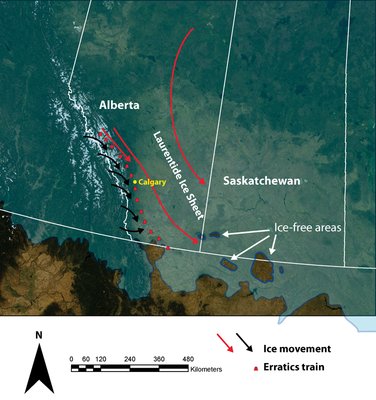
To gain an appreciation for how the convergence of two ice sheets can create a virtual conveyor belt for the transport of erratics, we have to travel to the foothills of the Rocky Mountains in Alberta, Canada.
This amazing trail of pebbly quartzite erratics, called the Foothills Erratics Train, can be traced from the forested Macleod River region in Alberta to the United States-Canada border in western Montana 580 kilometers southward. Over most of its length, the trail is only a few kilometers wide, narrowing to less than one kilometer in some areas. Individual erratics range in size from less than a cubic meter to one rock that has the mass of 10 Stonehenges.
The source of the rocks is in the Great Divide in Jasper National Park. The rocks appear to have fallen onto valley glaciers, which carried them into the Foothills Erratics Train via glaciers in the Athabasca River Valley. Normally, mountain glaciers would spread into so-called piedmont lobes where they leave the mountains and spill out onto the plains, dispersing the rocks that they carry in a fan shape. Indeed, this occurred farther south in the American Rockies during the last glacial maximum about 20,000 years ago. However, in the case of glaciers flowing out of the Canadian Rockies, they encountered the western margin of the vast Laurentide Ice Sheet, which was diverted southeastward by the high topography of the range’s foothills. The Athabasca Valley Glacier carrying the erratics became a tributary to the Laurentide Ice Sheet and flowed southeastward with it.
This parallel flow of two ice streams, maintained by pressure from both sides, is quite analogous to the situation in Wales. As the two ice streams came together, they would have maintained a contact zone as the ice approached its easternmost limit in England. It is reasonable to believe that the contact zone of ice carrying bluestone erratics — and maybe some other stones from South Wales — would have resulted in an erratics train rather than a fan.
Unlike the blocks of the Foothills Erratics Train that fell onto the surface of the glacier from cliffs in the Rocky Mountains, the bluestone erratics train would have been plucked from outcrops and initially transported within the ice. However, once entrained, the blocks would have been transported relatively high within the body of the glacier (see sidebar, p. 39). By using the Canadian Rockies analogy, it suddenly becomes clear how the boulders of Stonehenge could have been deposited in a trail across southwestern England — and thus would have been easy pickings for Neolithic Britons.
In his recent book, “Solving Stonehenge,” archaeologist Anthony Johnson laid down a reasonable challenge to proponents of a glacial erratic origin for the bluestones. Why, he asked, did the early builders of Stonehenge choose only exotic stones when they created the first stone circle if Salisbury Plain was littered with a variety of glacially transported rocks, including local sarsen rock types? This is a good question, to be sure. The problem is, his questions are based upon a false assumption — namely, that we know exactly which stones were used in the early arrangements or settings at Stonehenge. We do not know. In fact, it is probable that these stones were intermingled.
When the original circular ditch with its berm and wooden palisade (Stonehenge’s first phase) was later enhanced by a monument built of stone, only smallish stones of up to four tons in weight were used, as the pits left by the stones show us. The bluestones would have been easy to find by following a trail across a familiar landscape.
The Stonehenge builders probably initially used the closest available blocks and then gathered stones from farther and farther afield, toward the west and maybe the north. The overriding factor in the rocks' selection appears to have been a comparatively easy hauling distance to the site. Availability apparently trumped suitability. Nothing in the evidence suggests a magical or mystical link between Stonehenge and the Preseli Hills. The builders of Stonehenge probably had no idea where the stones had come from. As pointed out in recent decades by dissenting archaeologists like Aubrey Burl of Hull College in England and Stephen Briggs of the British Royal Commission on Ancient and Historical Monuments, this same bluestone was used for both the Stonehenge monoliths and for the manufacture of standard axe-heads — suggesting no special regard for it. The bluestone arrangements at Stonehenge were reorganized many times. This probably reflects the utilitarian fact that the builders never did manage to find enough bluestones to complete the task at hand, whatever that might have been.
Stonehenge may have been a spiritual or magical temple, but the project engineers who designed and built the monument had to address the same practical issues — namely, material sourcing and supply within available labor and material constraints — that any modern construction project faces. Although we may be no closer to answering the big question of what Stonehenge’s original purpose was, we can now say with ever more certainty how the giant stones arrived on Salisbury Plain. Will there ever be a final conclusion to this marvelous, prehistoric mystery? Perhaps not. But evidence from the fields of geology and glaciology is — after decades of neglect — coming to the fore.
© 2008-2021. All rights reserved. Any copying, redistribution or retransmission of any of the contents of this service without the expressed written permission of the American Geosciences Institute is expressly prohibited. Click here for all copyright requests.