
by Mary Caperton Morton Tuesday, July 3, 2018
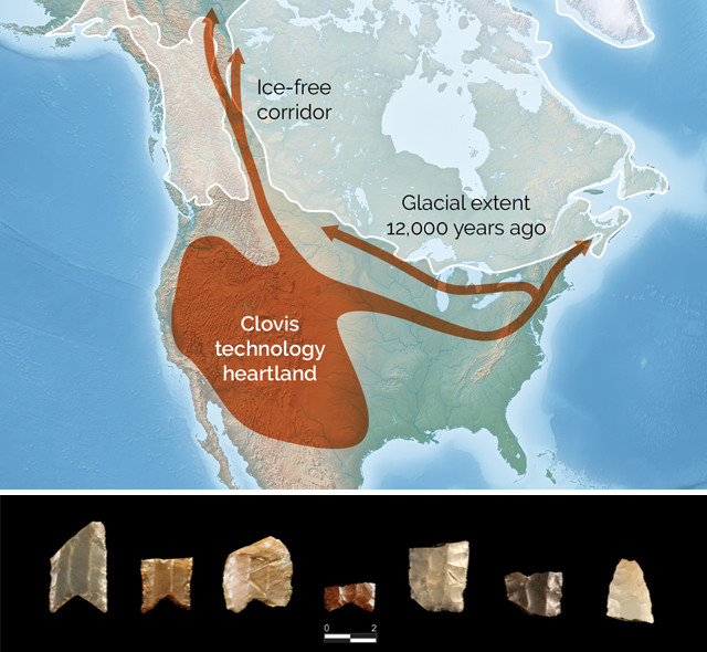
Several routes have been proposed for the first human migrations into North America, with the most widely accepted suggesting a north-to-south traverse through an ice-free corridor east of the Rocky Mountains. But a new analysis of hundreds of spearpoints found across the western U.S. is turning this model on its head. Credit: map: K. Cantner, AGI; photo: Heather Smith.
During the last ice age, long before people first entered North America, much of the Canadian and American Rockies were buried under massive ice sheets. As the ice age waned about 13,000 years ago, an ice-free corridor 1,500-kilometers long and several hundred kilometers wide opened east of the Rocky Mountains.
Traditionally, archaeologists thought that the first Americans traveled over the Bering land bridge from Asia into Alaska, and then continued south into the Americas through this ice-free corridor. But recent studies have suggested earlier timeframes and other routes for the earliest migrations. And new research indicates that travel through the ice-free corridor actually flowed from south to north, implying that by the time the corridor opened, people had already reached what’s now the U.S. Southwest via a coastal route.
The evidence comes from fluted projectile points, which are unique to the Americas. The earliest fluting technology, known as Clovis for its initial discovery near the town of Clovis, N.M., dates to between 13,400 and 12,900 years ago. The characteristic flute is a long flake removed from the base of the blade, allowing for the point to be attached to a wooden shaft or lance. Fluted points have been found from the Southwest to the Plains to the Great Lakes and all the way up to Alaska, but “they’ve never been used in a dataset that offers a continentwide perspective,” says Heather Smith, an anthropologist at Eastern New Mexico University and lead author of the new study, published in Proceedings of the National Academy of Sciences. Smith, and co-author Ted Goebel of Texas A&M University, analyzed 246 fluted spearpoints using geometric morphometrics — a digital analysis technique used to quantitatively assess shape — and cladistics to study relationships between different fluted points from across North America.
“We were looking for groups of fluted points that share similarities in both ancestral and derived characteristics. Just as biological organisms evolve over time, so do manufactured objects,” Smith says.
The original Clovis points have a very shallow, concave base and are somewhat wide with flutes that only extend a quarter to a third of the length of the projectile point. The team chose to focus their analysis on the base of the spearpoints, so they could include points with broken tips — a very common occurrence in the archaeological record. “The majority of the points we find are broken. Limiting ourselves to complete artifacts greatly limits the sample size,” Smith says. And while the tip of the spear may get all the glory, the shape of spearpoint base is just as indicative of technical skill: “Since you have to attach the base to the shaft, it’s probably the more time-consuming, customized part of the instrument. Ultimately, the base is better preserved and retains the most technological traits that are characteristic of a group’s entire projectile technology.”
By comparing slight differences in fluting techniques, Smith and Goebel tracked the spread of spearpoint technology across North America. To their surprise, they found that fluted points from Alaska and the Yukon derived from the original Clovis points. This implies that the makers of the northern points were descended from the makers of the southern points, not the other way around. “Dating of the archaeological sites where the points were found from the Southwest through the ice-free corridor into Alaska also matches this south-to-north gradient; the sites get younger as you go north,” Smith says.
The findings also complement recent archaeological, genetic and ecological studies of the timing and viability of the ice-free corridor for human habitation. Genetic studies of bison fossils found along the corridor suggest that bison began moving into the corridor from the south roughly 13,000 years ago. “If large animals were able to survive in the corridor, that means humans were too,” Smith says. The bison studies found that members of the southern bison clade reached northern Yukon by 12,300 years ago. “That’s about the same time that we see fluted points in the Arctic.”
“It’s always neat to see independent lines of evidence all lining up, and it’s especially fascinating when the story they are telling is the exact opposite from the traditional viewpoint,” says Quentin Mackie, an anthropologist at the University of Victoria in British Columbia, who was not involved in the new study. Other corroborating lines of evidence include studies indicating that Pleistocene megafaunal extinctions began in the south and progressed north, as well as ecological studies suggesting the corridor opened from south to north starting about 13,000 years ago, much too late to explain several southwestern archaeological sites that predate this time.
The studies “indirectly support an initial coastal migration route into the Americas,” Mackie says, with the first Americans following the coastline from Alaska and British Columbia down into the Pacific Northwest and farther south. “It’s too early to say whether this is definitive evidence for a coastal route, but you can certainly craft a nice story around it.”
© 2008-2021. All rights reserved. Any copying, redistribution or retransmission of any of the contents of this service without the expressed written permission of the American Geosciences Institute is expressly prohibited. Click here for all copyright requests.