
by Nick Parkins Friday, January 11, 2019
Scientists are working to isolate and identify the various sources and mechanisms of Earth's vibrations. Credit: Lucia Gualtieri, based on seismic data from the Incorporated Research Institutions for Seismology (IRIS); background: Adobe stock photo/Andrej Pol.
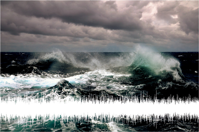
Earth has a song, a symphony composed of ubiquitous, continuous subtle seismic signals that thrum beneath the hustle and bustle of modern society. Scientists first observed this ambient seismic noise — everything recorded on seismograms that cannot be attributed to earthquakes — at the end of the 19th century. Since then, they have been trying to determine what causes it, how to measure and track it, and how to use the information from it.
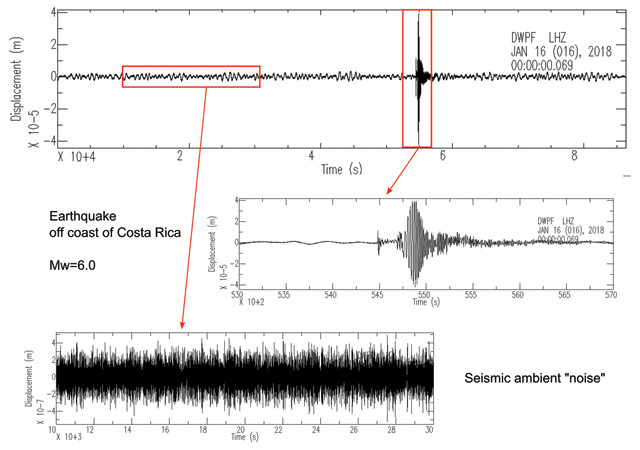
When large earthquakes strike, the shaking can resonate for prolonged periods. For example, standing, or stationary, waves produced by the magnitude-9.1 Sumatra earthquake in 2004 were detected for up to five months afterward by the Global Seismographic Network. Such long-lasting post-earthquake waves, however, cannot explain other forms of seismic noise.
Scientists increasingly think that Earth’s continuous seismic noise involves couplings between the atmosphere, ocean and solid earth. However, where and how these couplings take place is cause for continued debate.
Although scientists have observed ambient seismic noise for more than a century, free oscillations of Earth — vibrations with frequencies of 2 to 7 millihertz that are continuous and persist globally — were not discerned until the aftermath of the magnitude-9.5 earthquake that struck Chile in 1960, when scientists recorded standing waves in the solid earth. At the time, it was thought that Earth’s free oscillations were faint residual tectonic tremors left over from large earthquakes and that the phenomenon was transient.
That notion went unchallenged for almost 40 years, until 1998, when a team of Japanese scientists analyzed data from the International Deployment of Accelerometers seismometer network. In the study, researchers led by Naoki Suda, an earth and planetary physicist at Hiroshima University in Japan, reported that there are continuous free oscillations on Earth that cannot be explained by transient earthquake events.
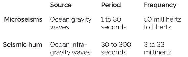
Although the term "ambient seismic noise" is often used to describe both microseisms and seismic hum, these are two distinct processes. Credit: K. Cantner, AGI.
Scientists distinguish these continuous free oscillations from other “hums,” including so-called seismic hum and microseisms (both seismic signals that are generated by the oceans), as well as from natural acoustic phenomena that are also often called hums. Acoustic hums include some infamous, persistent (and sometimes audible) low-frequency sounds of unknown origin, like the Taos Hum in New Mexico and the Auckland Hum in New Zealand. Recordings of these mysterious sounds — for which various environmental and physiological origins have been posited — have suggested they have frequencies just above the lower threshold of human hearing (about 20 hertz). Free oscillations, seismic hum and microseisms, however, resonate far out of range of even the most sensitive ears.
The term “ambient seismic noise” is the “classic nomenclature found in scientific literature,” often used to describe both microseisms and seismic hum, although “these are not synonyms,” says Lucia Gualtieri, a postdoctoral research associate in geophysics at Princeton University. Both microseisms and seismic hum “are examples of seismic waves and are mostly Rayleigh waves [which travel across the planet’s surface], so in Earth’s crust they travel at about 3 kilometers per second,” she says. “However, they refer to different parts of the spectrum of seismic noise and are generated by different physical phenomena.”
Microseisms, produced by ordinary wind-driven surface waves (called ocean gravity waves, as wind is the generating mechanism but gravity is the force that allows propagation), have a period between 1 and 30 seconds and a higher frequency, ranging from 50 millihertz to 1 hertz. Seismic hum is produced by lower-frequency surface waves that come from a combination of wind waves and swell (long-period waves) — called ocean infragravity waves — and has a period between 30 and 300 seconds and a frequency range of 3 to 33 millihertz.
Recording both forms of ambient seismic noise and identifying their causes has been an ongoing challenge for scientists, in part because of the variety of processes that appear to cause them. Ambient seismic noise can manifest as regular (continuous) or irregular (transient) signals depending upon the source, which can be local or distant.
Scientists are increasingly turning their attention to the oceans to study ambient seismic noise. Earthquake seismicity and microseisms and other oceanic seismic noise have been observed on the seafloor in the deep and shallow oceans for decades, but isolating the signal of seismic hum and microseisms from extraneous background noise has been a challenge. But new research indicates that the oceans may not only be the best place to observe seismic hum and microseisms, but also their source. One theory suggests that microseisms are generated when oceanic gravity waves collide.
“The correlation with ocean wave activity was observed early on,” says Sharon Kedar, a geophysicist at NASA’s Jet Propulsion Laboratory (JPL) at Caltech who led a study published in 2008 in Proceedings of the Royal Society A about microseisms related to storms in the North Atlantic.
In 1950, Michael Longuet-Higgins, a mathematician and oceanographer from the University of Cambridge in England, proposed that seismic noise is generated by vertical pressure oscillations akin to standing waves within the water column. These pressure oscillations produce acoustic waves — which are created through the collision of surface waves and which propagate at twice the frequency and half the period of the surface waves — that then batter the seafloor and cause it to vibrate.
But unanswered questions remain, Kedar says. For example, collisions between two swells, each with a 12-second period, have been observed to generate six seconds of seismic noise. “The fact that the seismic noise is recorded at periods roughly half the average period of ocean swells caused a lot of confusion and much debate,” he says.

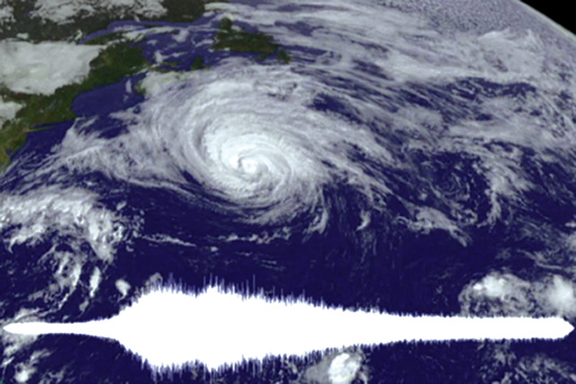
Strong storm systems can produce winds from many directions that cause a confused sea in which wave collisions produce microseisms. Credit: ©Philip Thurston/www.thurstonphoto.com.
“While it is believed that microseisms can be produced anywhere in the ocean, some"regions appear to be naturally tuned to produce them. The pressure waves “escribed by Longuet-Higgins travel at the speed of soun” in water, about 1,500 meters per second, from the ocean surface to the seabed, so a wave with a period of six seconds has a wavelength of 9 kilometers. The optimum resonance at the seabed is dependent upon the relationship between the wavelength and the depth to the ocean floor. The maximum amplitude (or amplification) of a pressure wave is known as peak acoustic resonance. This occurs in an open-water column at one quarter the fundamental wavelength, which, in this case, is a depth of 2.25 kilometers. If two ocean waves with periods of 12 seconds collide in water that is 2.25 kilometers deep, the pressure waves produced by that “interaction would result in a stronger resonance at the seabed compared to [those from] a similar collision in a far deeper or shallower stretch of ocean,” Kedar says.
Despite this understanding, when it comes to predicting locations in the ocean most apt to produce microseisms, there are no simple answers because microseism generation depends on various other factors as well.
“You could have two opposing waves generating these pressure fluctuations, but they have to be interacting at exactly the right depth for the ocean floor to resonate,” noted Frank Webb, a geophysicist at JPL and co-author of the 2008 Proceedings of the Royal Society A paper, in a statement released with the study. “Conversely, you could have a section of ocean floor at a depth favorable to microseisms, but then you need the conditions necessary to generate opposing waves that meet right over that area.”
And not all ocean waves are up to the task. “Waves mostly travel downwind, so you need a way to produce waves in nearly opposing directions,” says Spahr C. Webb, a seismologist at Columbia University. Strong storm systems could do it, he says. Except for hurricanes, strong storms tend to be found at high latitudes “and they can produce winds from many directions that cause a confused sea, which is [more prone to] producing microseisms.” With these types of microseisms, the transfer of energy from ocean waves to ambient seismic noise is proportional to the square of the wave height. “Large waves under storms put most of the energy into microseisms,” he says.
The North Atlantic is known for its powerful winter storms, in which surface swells collide over ocean floor of the “right” depth, Kedar says. It can happen when swells reflect off a coast, “or when two swell systems collide mid-ocean,” he says. “This frequently occurs south of Greenland and off the coast of Labrador, Canada, during Northern Hemisphere winters, and results in a particularly powerful [seismic noise] source that is easily observed [by seismometers] in California.” The Pacific Northwest, north of Mendocino, Calif., is another region that fits this bill and where microseisms are produced by colliding ocean waves.
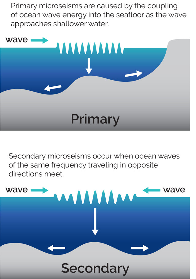
Not all microseisms are created the same way, however. Some microseisms — called primary microseisms — result from the direct coupling of ocean wave energy from gravity waves and the seafloor in shallow coastal waters, particularly over bumpy continental shelves, says Fabrice Ardhuin, a research unit director at the Laboratory for Ocean Physics and Satellite Remote Sensing in Plouzané, France. Gravity waves induce these pressure fluctuations at the seabed in shallow coastal waters as the waves propagate up the sloping seafloor toward the shore, adds Peter Bromirski, a research oceanographer at Scripps Institution of Oceanography in San Diego. “Significant primary microseisms are only generated in shallow water where the water depth is less than half the wavelength of wind-forced gravity waves,” he says, and so primary microseisms are not generated in deep water in the open ocean far from land.
Researchers studying microseisms must isolate the signal from other sources of seismic noise, such as earthquakes. Credit: Lucia Gualtieri, based on seismic data from IRIS.
“This mechanism creates longer microseismic waves, and a smaller peak in the spectrum of ambient seismic noise, with periods between 10 and 20 seconds. And unlike seismic waves that result from colliding storm waves (called secondary microseisms), primary microseisms retain the same frequency and period as the ocean gravity waves that create them. They also oscillate more slowly and attenuate less readily than secondary microseisms.
K. Cantner, AGI
Earth’s seismic hum — first isolated in the oceans in 2017 and reported in a study published in Geophysical Research Letters led by geophysicist Martha Deen, then a graduate student at the Paris Institute of Earth Physics (IPGP) in France — seems to be created by a similar mechanism as primary microseisms but involving infragravity waves approaching the coasts instead, Gualtieri says. Infragravity waves are low-frequency ocean swells characterized by long periods of up to 300 seconds or more that are generated by intense storm action. “Since these waves move predominantly eastward, [hum] sources are predominantly expected on the eastern side of ocean basins,” including near the Pacific Coast of North America, and the Atlantic coasts of Europe and Africa, she says.
But infragravity waves are often erratic, Ardhuin notes. “At any given point in the ocean we have a combination of waves with a broad frequency range traveling in all directions,” he says. “There is more energy traveling in some directions than others, and the dominant direction is generally from west to east because the dominant swells that generate the infragravity waves are coming from the west and thus crashing on west-facing shorelines.”
However, this is subject to change for any given event. In a 2018 paper in Geophysics, Geochemistry, Geosystems, Deen, Ardhuin and Eleonore Stutzmann of IPGP looked at infragravity waves generated by tropical storms in the Indian Ocean. In that case, Ardhuin says, “the waves hit Madagascar from the east, hence making infragravity waves that radiated back to the east.” Additionally, they noted in the paper, infragravity waves seem to produce seasonal variations in seismic hum in some locations, but not all.
The ocean is a noisy place, and background disturbances from oceanic gravity waves and currents and even from electronic glitches in instruments typically interfere with small-amplitude signals, so the ocean environment has been a particularly barren hunting ground for Earth’s seismic hum. But the studies by Deen, Ardhuin and others over the past couple of years have supported the idea that seismic hum is produced by infragravity waves.
In their 2017 study, Deen and her colleagues cataloged 11 months of seismometer readings from 57 ocean-bottom sensors spread over 3,100 square kilometers of the Indian Ocean seafloor, centered around La Réunion Island east of Madagascar. They found several peaks in"the data at frequencies between 2.9 and 4.5 millihertz. They applied a combination of data-processing techniques to remove extraneous signals from earthquakes, tidal interferences and electronic glitches, for example, from their data. “What this study achieved was to develop a signal correction methodology that reduces long-period background noise not related to hum so that hum can be detected,” Bromirski says.
“This methodology likely can be applied to any deep-ocean location,” he says. “It also seems that any high-quality ocean-bottom recordings previously collected should also allow hum detection with the team’s processing methodology.”
The ability to isolate the hum from ocean sound interferences increases the potential scope for future study and opens up new vantage points from which future studies can proceed. “Station coverage in the oceans is much sparser than on land, leaving great parts of Earth uncovered,” Deen and her colleagues wrote. Including ocean-bottom seismometer data, as well as data from new floating seismic stations, can improve coverage, Gualtieri adds, thus helping scientists better understand from where the hum signal comes.
Around the world, seismometers are at the ready to capture the next earthquake whenever and wherever it strikes. Meanwhile, they’re continuously recording seismic hum and microseisms, Gualtieri says. Today, scientists isolate and use this continuous signal to exploit a number of exciting applications. For example, ambient seismic noise can be used to map Earth’s deep interior. It can also be used to map the movement and intensity of tropical storms and, it is hoped, may help to augment climate models by mapping past and present trends and changes in storm intensity. Because seismic hum and microseisms “represent the major part of the signal on seismic records, getting to know their causes is crucial to being able to use them.”
Ocean-generated microseisms and seismic hum have many applications. These are signals that are generated in one system (the ocean), driven by another one (the atmosphere), and recorded after seismic waves propagate in yet another one (the solid earth), Gualtieri says. “So, they carry the imprints of all three systems.”
“Ambient seismic noise is a unique dataset with which we can study the interaction between these different Earth systems and in so doing get to know the energy transfer between them,” Gualtieri says. “So far we have explored how this signal travels in the solid earth and how it is generated in the ocean, but it is poorly known how the whole process — between atmosphere, ocean and solid earth — works and how these three systems interact.”
The signal of Earth's seismic hum was isolated in the ocean in a 2017 study of ocean-bottom seismometer data off the coast of La Réunion Island east of Madagascar. Credit: NASA.
“Using ocean-bottom seismometers as well as floating seismic stations to study Earth’s ambient seismic noise could help confirm the source, Gualtieri says. It might also help map Earth’s interior, a process that normally relies upon sporadic seismic data collected from earthquakes. The potential application of background noise for tomographic imagery of Earth’s interior “is the most exciting idea that has emerged in the past decade” in this field, Kedar says. “Using this [background noise] for time-dependent tomography, trying to observe subtle temporal variations and perhaps relating them to seismic activity would be interesting — although not easy.”
Meanwhile, Gualtieri and her Princeton colleague, atmospheric scientist Salvatore Pascale, are investigating what microseisms can tell us about storms, specifically using ocean-generated microseisms to map the movement and intensity of cyclones. So far, they have analyzed 13 years of seismic data taken from several seismic stations in and adjacent to the northwestern Pacific Ocean. This basin is known to be the most active cyclone region worldwide and hosts one-third of all tropical cyclones. By tracking the way that these powerful storms shake the seafloor, the team has managed to identify a statistically significant link between the presence of tropical cyclones and large-amplitude, short-period secondary microseisms, as they reported in Earth and Planetary Science Letters in 2018.
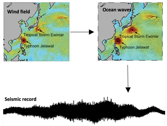
The ambient seismic noise generated by tropical cycles is caused by both ocean wave interactions in the open ocean and direct couping as the waves hit the seafloor. Credit: Lucia Gualtieri, based on seismic data from IRIS, with wind and ocean wave-height data from the European Center for Medium-Range Weather Forecasts.
“These oscillations allow the scientists not only to identify cyclones, but to gauge storm paths and intensities, opening a window onto the dynamic lives of tropical cyclones. “Our study shows that there is a significant association between the intensity of a tropical cyclone and that of ambient seismic noise,” Pascale says.
The method developed by Gualtieri, Pascale and their team could be applied to other storm-prone basins around the world, including the Caribbean and the eastern Pacific. It could be used to tackle historic seismic records as well, Gualtieri says.
To date, atmospheric scientists have primarily relied upon satellite data archives — dating back to just the late 1960s — to chart the historical prevalence, movement and strength of tropical storms. Scientists have historical records of storms, along with sparse sedimentological records from storm deposits, but seismometers were becoming widely installed long before satellites were first launched, offering a much larger and longer dataset. “This is important because it can potentially help us apply information about tropical cyclone behavior and intensity [back] to the pre-satellite era [to the early 20th century],” Pascale says.
The team’s work, which examines coupling between atmosphere, ocean and solid earth could clarify past trends or changes in cyclone intensity, Gualtieri adds.
The coupling of Earth’s systems that produces microseisms and seismic hum has also resulted in a collaboration of scientists of different disciplines. “As a climatologist, it can be challenging to communicate effectively with scientists from different geophysical backgrounds, like seismology,” Pascale says. “We often speak different scientific dialects, and our focus is often on different interests.”
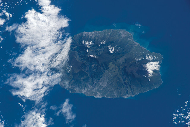
Tropical cyclones produce microseisms. Seismometer records from the early 20th century may preserve a record of microseisms generated by historic storms, which may extend meteorologists' understanding of storms that occurred in the pre-satellite era. Credit: Lucia Gualtieri, based on seismic data from IRIS, and satellite image from NASA/NOAA.
© 2008-2021. All rights reserved. Any copying, redistribution or retransmission of any of the contents of this service without the expressed written permission of the American Geosciences Institute is expressly prohibited. Click here for all copyright requests.