by Josh Knackert Wednesday, March 8, 2017

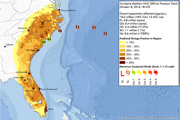
Predictions of power outages during Hurricane Matthew based on a new model incorporating detailed soil moisture data weren't far off from what was observed during the storm. Credit: courtesy of The Ohio State University
Power outages, most often caused by trees and branches falling on electric lines and transformers, are one of the most debilitating aspects of hurricanes, knocking out power to large numbers of people and businesses. With utility crews stretched thin, blackouts often extend for days, restricting access to clean drinking water and healthcare, and limiting the ability to cook and keep food from spoiling, especially in rural communities. Accurate predictions of storm-related power outages can help utility companies and emergency services anticipate and allocate needed resources.
In a new effort to improve modeling of where and when power outages caused by falling trees will occur during hurricanes, researchers are making use of frequent measurements of soil moisture provided by NASA’s SMAP (Soil Moisture Active Passive) mission, which began collecting data in spring 2015. Preliminary results, based on applying the new model to predict outages during Hurricane Matthew last fall, are promising, according to Steven Quiring, a climatologist at Ohio State University, who presented the research at the annual meeting of the American Geophysical Union last December in San Francisco.
Power outage prediction models consider a number of factors that affect vegetation — including elevation, wind speed and precipitation — to provide likelihoods that intense winds and heavy rains in hurricanes will compromise trees or other large vegetation. “In developing these prediction models, we found a couple of key features to consider, with soil moisture being one of the most important,” Quiring says. “Soil moisture is a good indicator of soil stability, as well as the health of vegetation.”
Regions that are too dry often have woody vegetation more prone to splintering in high winds, while especially wet regions tend to have heavier trees and tree limbs with more biomass, as well as higher likelihoods of trees being uprooted and tipping over. Thus, at both ends of the spectrum, the odds increase that trees and branches will fall on electrical systems and contribute to blackouts.
The new model incorporating SMAP data updates a previous version used by Quiring and his collaborators for a decade. The earlier model included less detailed soil moisture predictions based on a separate hydrologic model. The SMAP satellite, on the other hand, measures soil moisture around the planet in the top 5 centimeters of soil every two to three days, creating a continually updated global map of how much water is present in the world’s topsoils, and assessing whether the soils are frozen or not.
The team has only used the SMAP-based model to predict outages for one hurricane so far, predicting with 91 percent accuracy the number of people who lost power during Hurricane Matthew, which affected the southeastern U.S. coast from Florida to Virginia. The model predicted 4.5 million people would lose power, whereas the actual tally was about 4.1 million. Quiring attributes some of this inaccuracy to uncertainties in population numbers, densities and locations taken from census data with respect to utility infrastructure, particularly in rural areas. A more detailed picture of where people reside in rural areas would allow for more detailed local predictions, he says.
“With only one storm for comparison, it is too early to say whether the SMAP data make a significantly better model, but it looks promising in these early stages,” Quiring says. He notes that there’s room for improvement in the model, highlighting additional factors — like tree species, tree trimming practices, and utility grid features such as pole type and the use of underground lines — that likely impact storm-related power outages and could potentially improve the model’s accuracy if included. In the meantime, Quiring and his collaborators are applying their model to past hurricanes to see if its predictions match what actually happened.
Practical applications based on data from new satellites can sometimes take five to 10 years to develop, “so even a few simulations with the SMAP data within two years is impressive,” says Vanessa Escobar, mission applications coordinator for SMAP, who was not involved in the study. The team’s model “is an especially relevant example of how satellite data can improve everyday life,” Escobar says. “The potential to shorten power outages by better allocation of utility company resources could benefit the wallet of every taxpayer.”
Scientists hope to extend such models to make predictions for thunderstorms and blizzards, Quiring says, both of which can also cause extensive power outages over large parts of the U.S. Blackouts associated with severe weather cost the U.S. economy an average of $18 billion to $33 billion annually, according to a 2013 report by the President’s Council of Economic Advisors and the U.S. Department of Energy.
“Detailed data and standard methods for data collection are often our rate-limiting factors for creating and improving predictive models of this nature,” Quiring says. To combat this, his team is in the early stages of forming a consortium to bring together university researchers and utility industry representatives. Through the consortium, they hope to identify useful new data to collect and establish best practices for its collection. Improvements like these will lead to shorter power outages, Quiring says, lessening economic loses and alleviating some of the devastation caused by hurricanes and other severe storms.
© 2008-2021. All rights reserved. Any copying, redistribution or retransmission of any of the contents of this service without the expressed written permission of the American Geosciences Institute is expressly prohibited. Click here for all copyright requests.