
by Jane Palmer Monday, April 9, 2018
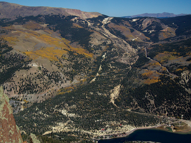
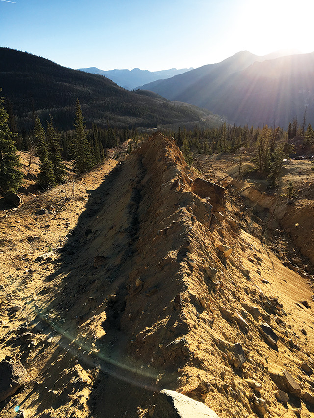
The enormous Slumgullion landslide in southwestern Colorado has been moving — sometimes imperceptibly slowly — every day for some 300 years. Credit: William Schulz, USGS.
In southwestern Colorado, a centuries-old “laboratory” looks out on the snowy peaks of the Lake City Caldera in a remote section of the San Juan Mountains. The lab’s scientists don’t wear white coats, but Gore-Tex and hiking boots, and they don’t work inside a building but on a 6.8-kilometer-long mishmash of red, brown and yellow earth topped with boulders, ponds and tilted spruce. Early settlers to the region called the mass Slumgullion, after an “everything-but-the-kitchen-sink” stew, with “slum” being an old word for “slime” and “gullion” an English term for “cesspool.”
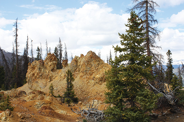
Slumgullion was first thought to be a large avalanche or glacial debris pile. But in 1883, a notorious prospector described it as a big landslide of yellowish clay — and his description was soon confirmed. Credit: Jane Palmer.
Slumgullion was first thought to be a massive train of debris deposited by glaciers or avalanches. It took a notorious cannibal to correctly describe the morass as a landslide. In December 1873, prospector Alferd Packer and five colleagues embarked on an expedition through the San Juan Mountains only to be snowbound by particularly harsh conditions. The truth of what ensued will never be known, but historians think that Packer killed his comrades and then ate them to survive until the spring. In 1883, Packer admitted to leaving his dead comrades by a big landslide of yellowish clay, an accurate description of Slumgullion’s geology.
Scientists soon confirmed that Slumgullion was, in fact, an enormous landslide, albeit a slow-moving one: It doesn’t crash down the hillside as a mass of rocks, earth and debris. Rather, it creeps along — imperceptibly to casual observers — at about a centimeter a day, sometimes faster, sometimes slower. And research suggests it’s been doing this for at least 300 years.
As such, the site provides a great opportunity for scientists to study what causes landslides to move, stop, speed up or slow down. Such research has allowed scientists to investigate slope stability and improve models that evaluate the potential threats posed by landslides all over the world — whether slow-moving like Slumgullion, or fast-moving like the one at Oso, Wash., in 2014.
“Slumgullion is arguably the most-studied slow-mover in the world, almost definitely in the U.S.,” says William Schulz of the Landslide Hazards Program at the U.S. Geological Survey (USGS) in Golden, Colo. It’s not the sort of slide that’s over in a day, he says, so it’s possible to learn a lot from it.
Studying a slow-motion landslide allows researchers to develop new hypotheses and test them repeatedly, Schulz says. And that’s just what they’ve been doing at this natural landslide laboratory since the late 1800s.
The first known scientific paper describing Slumgullion appeared in the U.S. Geological and Geographical Survey Annual Report in 1874. Then, in the late 1950s, USGS scientist David J. Varnes, known for establishing the international standards for landslide classification, first visited the slide. Along with colleagues, Varnes measured the movement at several places on Slumgullion and found that its velocity at a given spot was roughly inversely proportional to its width at that location.
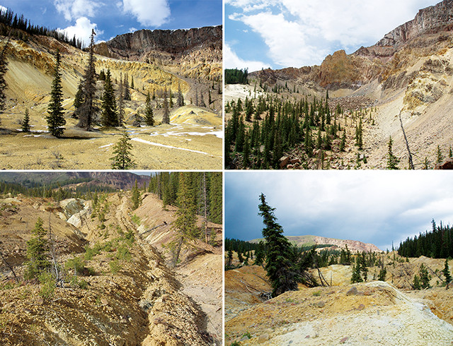
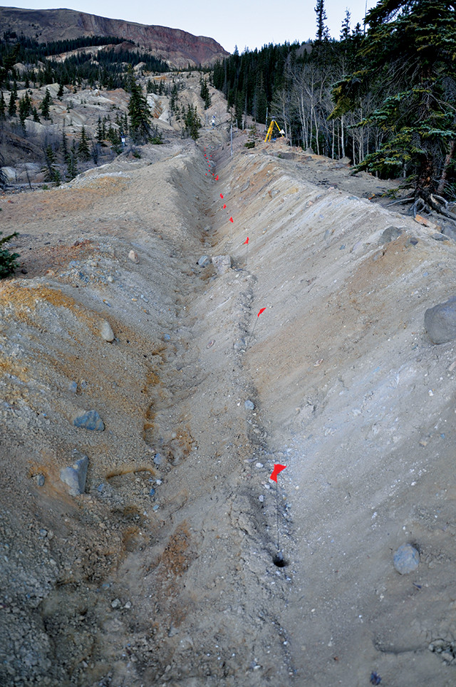
Scientists have been studying every fault, fold, crack and crevice on Slumgullion for several decades, The above two images show the landslide headscarp in hydrothermally altered volcanic rocks; top right also shows a talus pile near the head of the moving part of the landslide. The two images at right show parts of the middle of the landslide. Left: a furrow created by the strike-slip fault at the southern edge of the landslide with moving ground at the left and stationary ground at the right. Right: the hummocky surface and tilted trees near the fastest-moving part of the landslide. Credit: Credit: all: William Schulz, USGS.
Further studies in the 1950s and 1960s, in which scientists pounded wooden stakes into the slide and came back weeks or months later with tape measures, helped determine how much the earth had moved. Simultaneously, the researchers recorded rainfall between measurements.
By the 1990s, USGS began to step up its investigations of Slumgullion; researchers were keen to better understand the controls on landslides, and Slumgullion was considered a good natural laboratory that was relatively convenient to the USGS Landslide Hazards Program headquarters. USGS scientists mapped every fault, fold, crack and crevice they could find on Slumgullion while also repeatedly photographing hundreds of points on the landslide by air over a five-year interval.
Nearly all landslides consist of three basic parts: a head at the top of a slide, the middle and the downslope end, known as the toe. Slumgullion snakes 6.8 kilometers from its headscarp, the steep cliff that marks the upslope limit of where the hillside originally gave way, through the Oligocene-Miocene volcanic rocks exposed on the flank of the Lake City Caldera, to its toe, with widths varying from a skinny 200 meters in some parts to 1,000 meters in others.
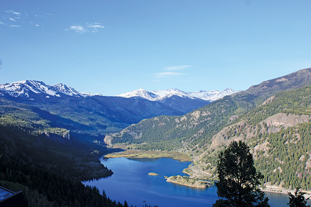
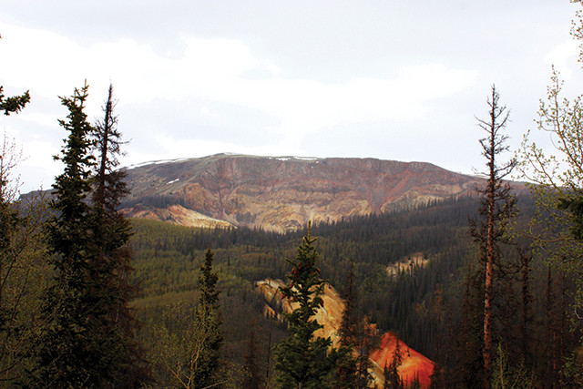
Slumgullion got its start about 700 years ago, when it dammed the Lake Fork of the Gunnison River to form Lake San Cristobal. Credit: Jane Palmer.
Radiocarbon dating reveals that about 700 years ago, the landslide surged into action, damming the Lake Fork of the Gunnison River to form Lake San Cristobal, the second-largest natural lake in Colorado. Only part of the slide is still actively inching along, a 3.9-kilometer-long stretch consisting of an estimated 20 million cubic meters of earth. Radiocarbon and tree-ring data indicate that this active section, which is approximately an eighth of the volume of the original slide, has been moving for the last 300 years.
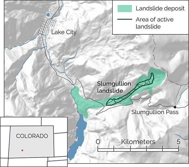
A landslide consists of a head, a middle and a toe. Slumgullion started moving in earnest 300 years ago. Today, only part of the slide is actively moving: a 3.9-kilometer-long stretch carrying 20 million cubic meters of earth. Credit: K. Cantner, AGI.
This mass doesn’t move the same speed all the time. In the dead of winter, its movement is barely perceptible even to precision instrumentation; at other times, parts of the slide have moved at more than 2 centimeters a day.
Nonetheless, during the last three centuries, Slumgullion has always been moving, its slow creep taking it between about 2 and 7 meters a year. While many slow-moving landslides move intermittently over short periods of time, perhaps during a particularly wet year or series of wet years, Slumgullion never seems to stop. “The fact that it chugs along day after day, year after year, is very impressive,” says Rex Baum of the USGS Landslide Hazards Program.
The combination of data from the USGS maps compiled over the years revealed that the slide wasn’t just a single lump of earth moving in unison. Rather, it consisted of about a dozen independent blocks, each of which can move at different rates. “When you put the data together, you’ve got this really nice kinematic map that shows how all those [blocks] are working together,” Schulz says, “What’s following, what’s blocking, what’s leading the procession, for example.”
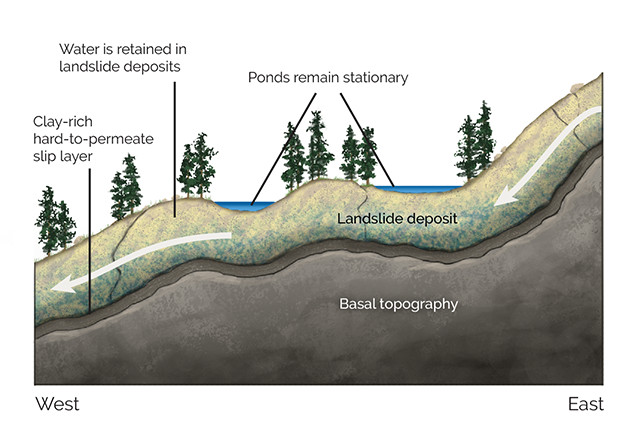
Ponds atop the landslide helped researchers reveal the topography beneath the slide: The appearance of the ponds changes over the years as the landslide moves, but the ponds themselves do not move. The locations of the ponds indicate depressions in the basal topography. Credit: K. Cantner, AGI.
Many patterns of motion found at Slumgullion have now been observed elsewhere. At other slides, for example, scientists have found extension, or stretching, in the upper parts and shortening in the lower parts, similar to what they mapped at Slumgullion. “That gives us some clues about the distribution of stresses within the slide and can be used to better understand the mechanisms of motion,” Baum says. “It means we are able to improve the accuracy of stability analyses of the slides.”
Sleuthing out the moving parts of a slide can ultimately help scientists determine how to mitigate impacts from a potentially damaging landslide. “By identifying which parts are less stable, it helps to pinpoint where you would concentrate your efforts in trying to stabilize the slide,” Baum says. The studies at Slumgullion have shown that one of the most important tasks when assessing a new slide is to map its kinematics — because different parts of a landslide often move at different speeds. “If you’re going to try to mitigate anything, you have to understand what’s happening first,” says Jeff Coe of the USGS Landslide Hazards Program.
Using on-the-ground mapping and GPS data helps researchers determine how Slumgullion is moving. Credit: Jeff Coe, USGS.
The nature of a landslide — its physical characteristics and the landscape on which it sits — and the “nurturing” environmental conditions combine to drive a particular landslide’s activity. On the environmental side, Coe and his colleagues have further investigated how water affected the Slumgullion slide. From July 1998 to March 2002, the researchers measured the velocity of Slumgullion throughout the year. They found that the landslide moved fastest in late spring and summer, up to 2.4 centimeters per day in places, and slowest in the depths of winter when it moved less than 0.1 centimeter per day. Following on from previous work, Coe hypothesized that the slide’s movement is triggered by higher groundwater levels, an idea confirmed by GPS and extensometer data (which also measures the movement of material). And higher groundwater levels are directly related to seasonality in this montane region.
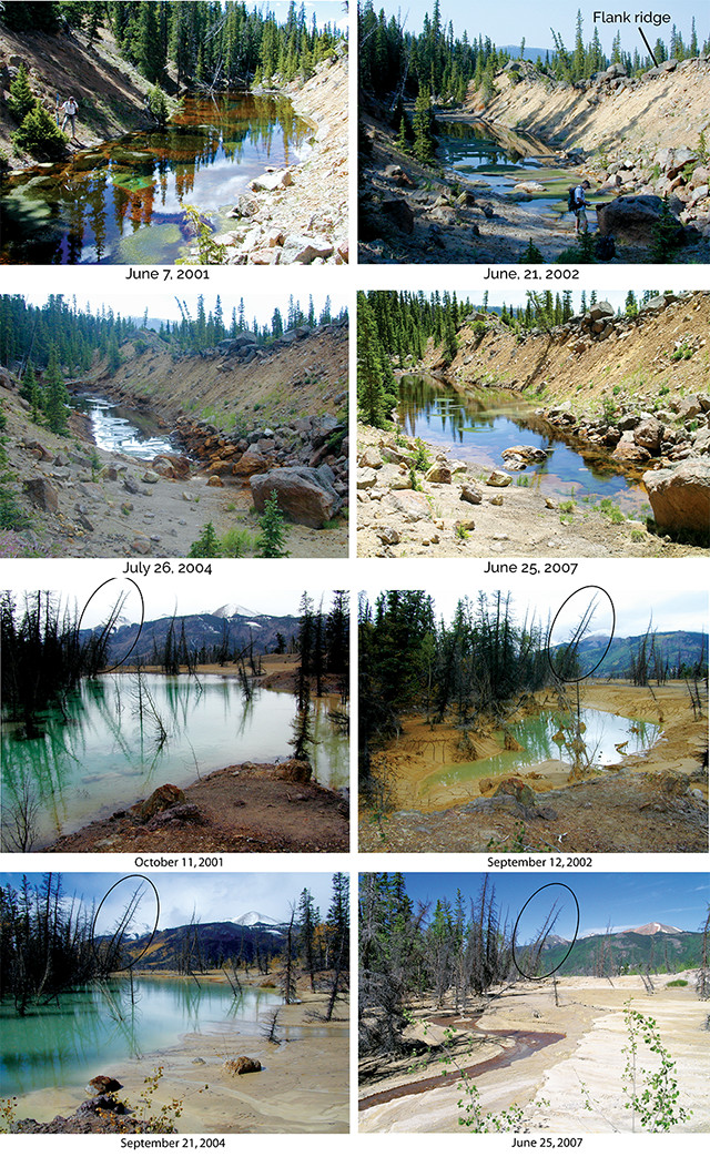
These ponds on the surface of Slumgullion show the basal topography. As the landslide material moves downhill, the ponds change shape. The two tilted pine trees (circled in the bottom four images) can be used for reference. Credit: Credit: all: Jeff Coe, USGS.
In winter months, water is less available to the landslide material because it is stored as snow and ice and doesn’t soak into the ground as much. In late spring, snow on the surface of Slumgullion melts, and, even when the ground is frozen, the broken-up nature of the slide means that open fractures and conduits exist for surface water to seep toward the water table. When groundwater levels are higher, there’s more water in the gaps between the landslide material, so pore pressures increase. “This pressure increase drives the landslide to speed up,” Coe says. Similarly, he says, in summer months, seasonal thunderstorms boost water levels in many, if not most landslides, he says. “So it is water that really controls the rate of landslide movement.”
Nonetheless, the relationship between moisture and motion isn’t exactly the same for all landslides, in part because of the “nature” side of the equation.
In addition to the many blocks or units that usually make up a whole landslide, another important internal factor that can influence a slide’s movement is the shape of the stationary land that lies below the slide. But determining the shape of this basal surface can be a tricky endeavor, Coe says.
“The best way to determine the shape is by drilling and trenching, but the cost of doing that work can be prohibitive,” Coe says. Luckily, at Slumgullion, the scientists found more accessible clues as to what lies beneath the surface. When Coe tracked the slow slip of the landslide between 1998 and 2007, he found something odd: The ponds on its surface changed shape but stayed in place, even as the slide material — including the trees — moved on downhill. “The slide just keeps whipping on through, but the pond stays put,” Schulz says. This was the first indication that what was happening on the surface reflected what the slide looked like at the base 13 meters below.
Coe inferred that for these ponds to stay in one place, the landslide is most likely moving over an irregular slip surface. It helps to picture the base as an undulating surface, not flat but one with bumps and valleys, Coe says. As landslide material moves over the top of that undulation, it also goes up or down, reflecting the topography of the base. “Every time it goes down, that’s a depression, not only at the bottom of Slumgullion, but also on the surface of the slide,” Coe says. “The topography is translated from bottom to the top: Bumps on the bottom are bumps at the top, depressions on the bottom are depressions on the top.”
The depressions on the surface tend to fill with water, forming ponds. And since the depressions on the underlying hillslope don’t move, the locations of the ponds remains the same. “Once we saw what was going on, it all made sense,” Coe says.
And when the scientists realized what was happening at Slumgullion, they knew that troughs, undulations, depressions and other features on other slides could also yield valuable information about their bases. If geotechnical engineers are trying to mitigate a slide, the industry standard requires boring holes to determine how deep the slide is, and how that depth varies across the slide. So, while they’ll still have to bore holes, if they “can make interpretations based on surface features, that helps interpolate between borings,” Baum says, and “that can save some money.”
Atmospheric pressure changes, caused by the regular daily cycle in the sun's heating of the atmosphere coupled with the moon's gravitational pull that causes atmospheric tides, seem to affect Slumgullion's speed. Researchers found that each afternoon, when the atmospheric pressure is lower, Slumgullion speeds up. During the night, when the converse is true, it slows down. Credit: William Schulz, USGS.
Today, USGS has three sites on the slide where scientists continuously monitor its movement, near-surface stress, groundwater pressure and weather conditions. The scientists use these data to pick apart the complex interplay between rainfall, snowmelt, groundwater pressure, stress propagation up and down the landslide, and the landslide’s speed.
round-based interferometric synthetic aperture radar (InSAR) is helping USGS scientists and collaborators measure Slumgullion’s sensitivity to rainfall. InSAR showed that a mere quarter of a millimeter of rainfall can cause the ground to speed up by a factor of five in just a few hours. The root of this sensitivity lies in the height of the groundwater table, which sits just a meter below the surface in many locations of Slumgullion, especially during the wet season, and the effect of rainfall on the strength of faults along the edges of the slide, Schulz says. Infiltrating groundwater can lead to fast changes in groundwater pressure and trigger an acceleration of movement. “Since it’s moving, any upset to the force balance [acting on the landslide] can have an immediate effect,” Schulz says. And that should be the case for any moving landslide, whether slow or fast, he says.
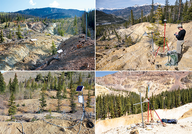
Scientists use a variety of instruments to monitor landslide movement, in situ pore-water pressures and meteorological conditions. Credit: Credit: left two: Jane Palmer; right two: Jeff Coe, USGS.
Another intriguing factor that seems to affect Slumgullion’s speed is changing atmospheric pressure. Like the twice-daily tidal cycle caused by the moon, the sun’s daily heating of the atmosphere coupled with the moon’s gravitational pull causes atmospheric tides, which are daily highs and lows in atmospheric pressure. To most people, this change in pressure is barely perceptible and certainly not visible, but even these subtle oscillations can influence Slumgullion’s movement, Schulz says.
Using aboveground pressure transducers on the land surface to measure the atmospheric pressure and extension transducers to measure the movement, Schulz found that each afternoon, when atmospheric pressure is lower, Slumgullion speeds up. At night, when the converse is true, it slows down. As the atmosphere extends into the subsurface soil, rapidly decreasing atmospheric pressure from the daily fluctuations can reduce the base load, decreasing the slide’s resistance and increasing its speed.
Schulz’s mathematical model of atmospheric tide-induced movement could also apply to other landslides, he says, and indicates that fast-moving storm systems, which bring about rapid pressure variations, could also influence landslide activity in the short term. When weather or storm systems persist for days or longer, they could additionally influence the slide’s movement. For example, low atmospheric pressure transmitted to the groundwater table eventually results in lower pore-water pressure at the landslide’s base, strengthening and slowing the slide, Schulz says. High-pressure systems could have the opposite effect.
Scientists are also studying landslide deformation and movement from the air. Using Uninhabited Aerial Vehicle Synthetic Aperture Radar (UAVSAR), Eric Fielding from NASA’s Jet Propulsion Laboratory and his colleagues have reconstructed the full three-dimensional motion of Slumgullion and gleaned how it deforms at different depths. The team’s findings confirmed the deformations seen previously with GPS, the layout of the kinematic blocks, and the slower movement of the slide in the winter months. But, in contrast to earlier estimates of about 13 meters for the average depth of the landslide, Fielding’s team’s work suggested the average depth is only 7.5 meters.
The landslide has also proved a useful testing ground for new technologies, like UAVSAR and spaceborne InSAR, which can be used to study earthquakes as well as landslides. “We always work with the people who are making measurements on the ground, so we can calibrate our radar observations with the ground observations,” Fielding says. “Then we can apply these techniques to landslides in other places where there are no ground observations.”
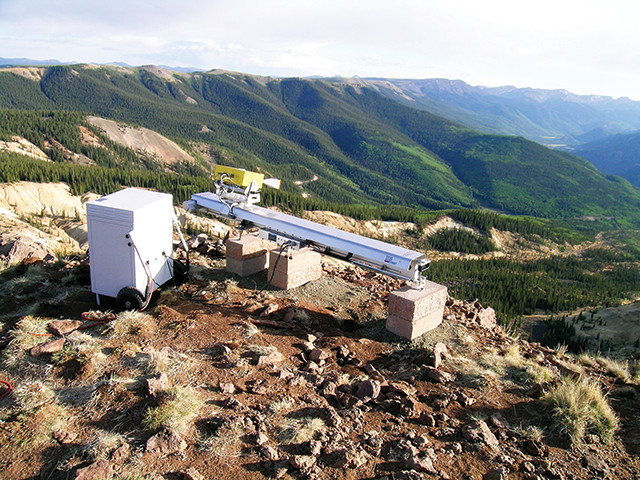
Ground-based interferometric synthetic aperture radar is helping researchers measure the slide's reactivity to rainfall. Credit: Jeff Coe, USGS.
The investigations at Slumgullion have made a valuable contribution to landslide science, but there’s still a lot to learn, Schulz says. For instance, while scientists have learned much about what makes Slumgullion tick, it still holds some secrets about its movement, such as why it has never stopped moving, year in and year out, for decades on end. “It’s a little bit of a mystery to me, how it’s able to keep going,” Baum says.
The rate at which material is being added to the slide from Slumgullion’s headwall appears slow compared to the rate of the movement of the active slide itself, Baum says. “It’s just hard to imagine how it’s had enough material to keep moving all these years,” he says.
One explanation appears to be related to a layer of soft, moist clay that squeezes into the spaces at the basal surface of the landslide and at the lateral shear zones. As the slide moves, this clay oozes its way toward the surface along the lateral shear zones and coats the side and bottom boundaries of the slide.
Baum observed the earliest evidence of this mobile clay in landslides in the mid-1980s in central Utah, and by 1993 scientists had seen it not only in Utah, but also in Honolulu and at Slumgullion. “We realized that this … was a widespread phenomenon occurring in various geologic and climatic settings,” Baum says.
n the 1990s, Baum began to comprehend the impacts this mobile clay layer had on the instability of slides like Slumgullion. When rain or snow meltwater soaks into the slide, this water tends to get trapped inside the main body of the slide, which is bounded by the slippery clay. It is this “contained” water that drives the movement of the slide. But water also seeps into the clay lining. “So it helps to keep the base of the slide wet and slippery,” Baum says.
The scientists termed this lubrication and trapping of water the “bathtub effect,” because a clay lining is less permeable than the material on the inside or outside of the “tub.” The bathtub effect also explains the instability of some other slides, and their ability to be reactivated after sitting stationary. Much of what’s been learned is “transferable to slow-moving landslides that are similar to Slumgullion, and there are a lot of those,” Coe says.
Slumgullion is starting to slow down and will stop moving altogether someday. One reason may be that the gradual loss of material from the head of the landslide, shown here, means that less material moves downslope each year, which reduces the driving force on the landslide. Credit: Jane Palmer.
Though Slumgullion continues to move every day, signs indicate it’s slowing down and will one day stop moving altogether.
From 1998 to 2010, Coe tracked the movement of the slide at 18 different locations using GPS and showed that the landslide was slowing down. In 2010, USGS scientists and Italian colleagues using ground-based InSAR also found that it was slowing down, moving at half the speed it did from 1985 to 1990, when it averaged nearly 15 millimeters a day.
Many factors may be influencing the slowing. For example, Coe says, the gradual loss of material from the head of the landslide over the decades could mean that less earth moves down each year, which reduces the driving forces on the movement. “It looks like the upper third of Slumgullion is going to be the first part that stops, essentially,” Coe says.
A second factor may be climate change. Using historical weather data, Coe determined that in Colorado, rainfall decreased and temperatures rose between 1895 and 2010; both factors can also impact the movement of the landslide. If these trends continue, Coe suggests, Slumgullion could stop moving very soon, even within the next 40 years.
In that event, studies could be conducted on the impacts of changing climate conditions on landslides. True to form, Slumgullion could continue to provide valuable information to scientists, even in its final days.
© 2008-2021. All rights reserved. Any copying, redistribution or retransmission of any of the contents of this service without the expressed written permission of the American Geosciences Institute is expressly prohibited. Click here for all copyright requests.