
by Karin Kirk Friday, February 5, 2016
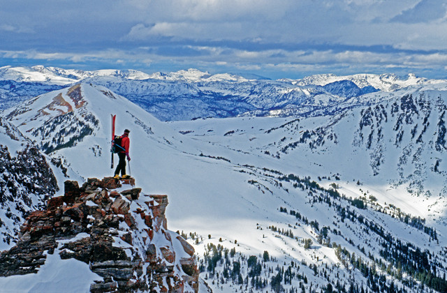
Extreme skier Tom Jungst in the Absaroka Range near Yellowstone National Park. As one of the pioneers of backcountry and extreme skiing, Jungst has experienced more than a dozen avalanches. Credit: ©Gordon Wiltsie/AlpenImage.
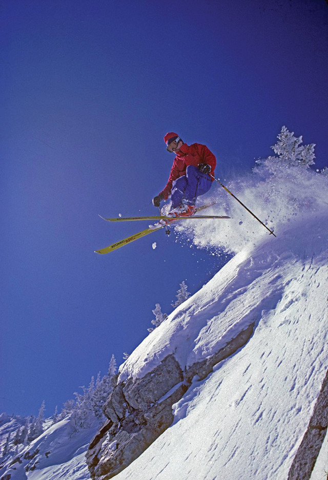
Jungst in 1987, skiing at Bridger Bowl in Montana. Credit: ©Gordon Wiltsie/AlpenImage.
The peaks of Montana’s Bridger Mountains rise 1,000 meters above Bozeman. The broad slopes of the mountain range are punctuated by stark, treeless bands as wide as superhighways, running 800 meters from the tops of the ridges down to the meadows below. These are avalanche paths, formed by slides that shed snow off the wind-loaded ridges, plunge downhill, and remove trees in their path. The scale of these white swaths leaves no doubt about the frequency and force of the events that formed them.
In the late 1970s and ‘80s, this mountain range was home to a group of skiers known as the Bridger Ridge Rats, who were pushing the boundaries of the sport. They skied off the groomed trails, into the backcountry and climbed to ridge tops that no chair lift reached. They eyed slopes that others hadn’t even considered skiing. Chief among these pioneers was Tom Jungst, who was featured in a 1985 article in Rolling Stone magazine that coined a new term: extreme skiing. While Jungst and his peers relentlessly pursued first descents, they became stars of dozens of ski movies. The media exposure led to increasing risks being taken in avalanche-prone areas. Jungst has survived numerous avalanches, but has lost several friends in avalanches and other alpine accidents. Now an associate teaching professor of mechanical engineering technology at Montana State University (MSU) in Bozeman, Jungst can reflect on the risks he took.
Recalling one particular avalanche, in which his life was spared when he got caught up in a tree while the avalanche continued for another 400 meters below him, Jungst says: “We were just going skiing. But then in one second it became so serious. We were pushing it back then. Lessons have been learned now. I’ve just been lucky.”
Many people are not so lucky. Each year in the U.S., about 30 people die in avalanches, with another 100 avalanche deaths occurring annually in the mountains across Canada and Europe. While the risk is mostly limited to those who opt to place themselves in harm’s way, avalanches also present a hazard for mountain roadways, mines and alpine infrastructure. Moreover, in mountainous regions like Central Asia, avalanches can pose significant threats to whole communities. Although the total number of avalanche deaths in remote regions is difficult to measure, an estimated 168 people were killed by a series of avalanches in Afghanistan alone in 2015; how many die throughout the rest of Asia is unknown.
The scientific study of avalanche processes began in the 1940s, when early research was undertaken by former members of the U.S. 10th Mountain Division — troops specially trained to fight in snowy mountainous regions. When these mountain-savvy men returned home to places like Utah, Colorado and Montana, they laid the foundation for the science of snow dynamics. With the confluence of highly trained skiers and mountaineers, a university setting, and a mountain range fraught with avalanche activity, MSU became one of the world’s leading institutions for snow science research.
All avalanches are caused by the same thing: a structural failure lurking somewhere within the snowpack. In Montana, academics, U.S. Forest Service avalanche forecasters and ski patrol practitioners are working together to understand how, where and when such failures might occur. The ultimate goal of this research effort is to keep those who work, play and travel in the mountains safe from avalanches.
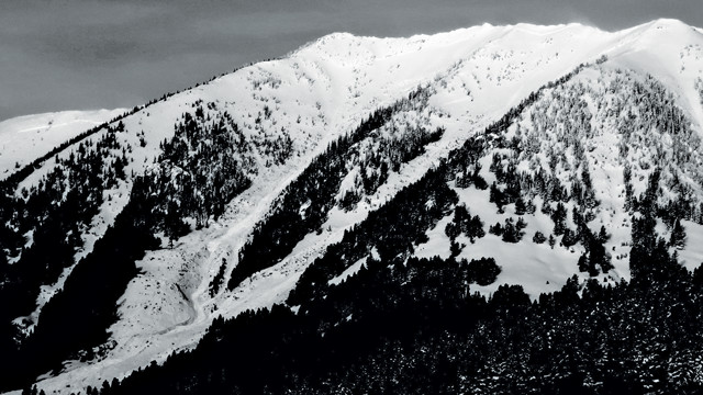
The broad slopes of the Bridger Mountains are punctuated by enormous avalanche paths that look like ski runs but are testaments to the frequency and power of avalanches. Credit: B. VandenBos.
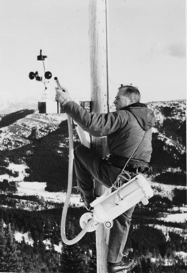
John Montagne, a snow researcher at Montana State University (MSU), calibrates an anemometer using a vacuum cleaner in the Bridger Mountains. Montagne was a veteran of the World War II 10th Mountain Division — a group of soldiers trained to fight in mountainous regions. Credit: image from the John Montagne collection.
MSU Civil Engineering Professor Ed Adams stands beside a white board, enthusiastically sketching a series of diagrams showing terrain, snow, sunshine, trees, water vapor and longwave energy loss. The interplay of variables in snow dynamics becomes increasingly evident as Adams narrates a crash course in his research. Adams approaches snow science from the most fundamental point of view: “The physics is the physics,” he says. He’s built a career illuminating a uniquely close-up view of the processes involved.
We’re standing in the SubZero Science and Engineering Research Facility, a one-of-a-kind combination of cold rooms and laboratories designed to study almost every aspect of snow, ice and other cold things. Here, everything from life in Antarctic lakes, to the effects of cold weather on exercise physiology, to the durability of heavy equipment in ultra-cold temperatures is examined. This multidisciplinary approach not only helps tackle a wide range of research questions, but helps secure funding for avalanche studies, which aren’t always a priority in research budgets, Adams says.
Perhaps the most intriguing feature of the SubZero facility is its environmental chamber, which is a large room that can simulate a range of meteorological conditions. The temperature of the ceiling can be controlled to simulate the sky, particularly the deep cold of the night sky, at 40 or 50 degrees Celsius below zero. A layer of fresh snow, which is made in the lab next door, is sieved onto a table. This snow is similar to typical wind-driven snow lying on a hillside. A small amount of water vapor is introduced into the atmosphere in the room. In time, delicate, feathery crystals emerge from the snow’s surface — called surface hoar. “It’s essentially frozen dew. And we’re the only people who make surface hoar under these simulated natural conditions,” Adams says.
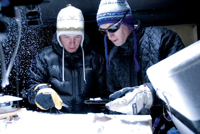
MSU graduate students collect snow samples in the MSU SubZero facility, a one-of-a-kind combination of cold rooms and laboratories designed to study almost every aspect of snow, ice and other cold things. Credit: MSU photo by Kelly Gorham.
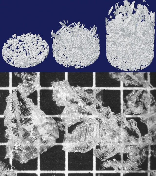
Top: CT scans of lab-grown surface hoar depicting the initial snow (left) and subsequent surface hoar development after 6.5 hours (middle) and 22.5 hours (right) at a temperature of minus 5 degrees Celsius. Bottom: Microscope image of surface hoar crystals on a 2-millimeter grid after 25 hours of growth at a termperature of minus 13 degrees Celsius. Credit: both: Brad Stanton.
While the glittering crystals are beautiful, particularly when they transform an entire landscape into a magical winter wonderland, they are a vexing problem for snow safety. The fragile crystals are preserved even when new snow piles on top. A buried layer of surface hoar creates a widespread, yet invisible, layer of weakness within the snowpack, the structure of which is like a house of cards. With each deposit of fresh snow, the load on the weak layer increases.
Adams’ team adds another layer of snow on top of the surface hoar, and then tests their lab-made snowpack to observe how it fails. “We can look at failures at the level of individual bonds [between individual crystals],” Adams says. “Everything comes down to the microstructure.”
In addition to the laboratory experiments, weekly visits to a field plot in the nearby Madison Range allow Adams and his team to record observations in the snow and then to test what conditions are needed to replicate these observations in the lab. Over time, his field team is developing an intuitive sense of what’s happening in the snow, he says. Based on the day’s weather conditions, they will predict what they are likely to see before they head out to make observations. “Snow properties change constantly,” Adams says. They’re “so dynamic and complicated.”
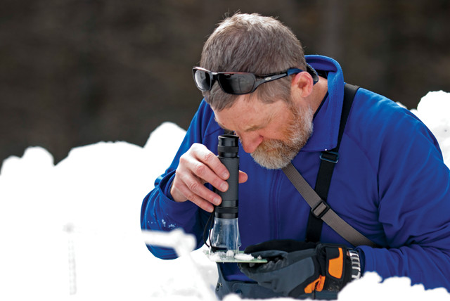
Snow and avalanche researcher Ed Adams studies snow crystals at a test site at Bridger Bowl. Credit: MSU photo by Kelly Gorham.
The work of Jordy Hendrikx, assistant professor of geography and the director of MSU’s Snow and Avalanche Laboratory, picks up where Adams’ work leaves off. Hendrikx’s laboratory is housed within the earth sciences department, one of the few in the country that offers specific degree programs in snow science. Its graduates are employed in a wide range of careers in snow research, avalanche forecasting, snow hydrology and transportation engineering. While Adams can grow and analyze surface hoar in laboratory conditions, Hendrikx wants to know how to improve our understanding of surface hoar all the way up to the scale of a mountain range.
The meteorological conditions that create surface hoar are well understood: cold, clear nights with just a hint of wind, and sufficient water vapor in the air. But surface hoar does not form evenly across a landscape; it is influenced by tree cover, elevation and slope aspect. The patchy nature of surface hoar formation makes it easy to miss in field observations, which can lead to deadly mistakes when traveling in avalanche terrain. Indeed, research suggests that, when seasoned users like mountain guides and avalanche professionals accidentally trigger avalanches, buried surface hoar is the most common culprit. This is where Hendrikx’s work comes in.
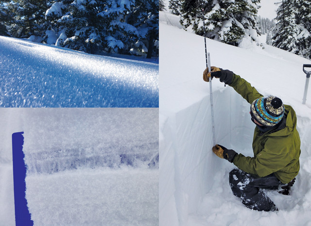
Surface hoar (top left), once buried, forms a dangerous weak layer in the snowpack (bottom left). Right: Sitting in a snowpit dug for research, avalanche researcher Karl Birkeland measures the slab of snow above the buried surface hoar layer. Credit: above and right: Karl Birkeland; far right: GNFAC.
To assess landscape-scale surface hoar formation, Hendrikx and his graduate students set up a field experiment in 2012 with the assistance of the ski patrol at the Yellowstone Club ski area in the Madison Range. The study plot contained 16 sample sites across a range of elevations, slope directions (called aspects), slope angles and forest cover. Each station gathered basic meteorological data like temperature and relative humidity, and featured a camera with a fish-eye lens that afforded a 180-degree view of the sky above the site.
This sky view showed how much of the sky was “visible” to the ground. This variable is important because, during clear winter nights, longwave radiation losses from the snow surface cool the snow dramatically, a process demonstrated in Adams’ SubZero lab. As a result of this heat loss, the snow becomes colder than the air just above it. Water vapor from the relatively warmer air condenses on the cold snow surface, growing crystals over the span of several hours. Because of the cooling effect of the night sky, surface hoar tends to form in open areas, rather than under forest cover. However, if the slope is too exposed, wind may disrupt the formation of the fragile crystals. Hendrikx used measured wind speed and topography to calculate a wind exposure index for each station.
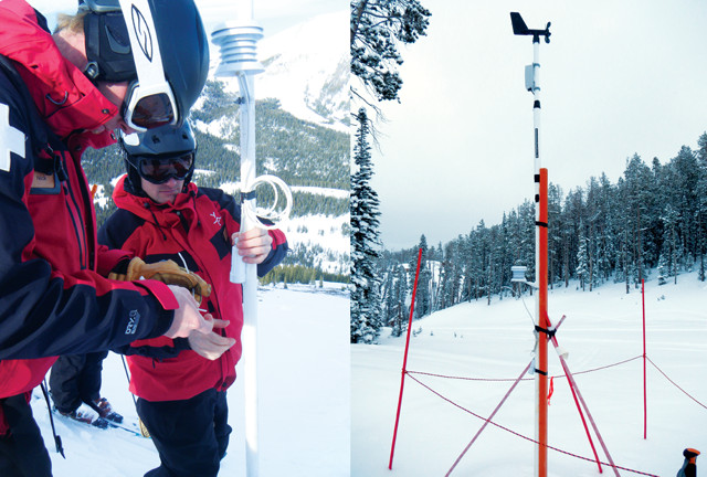
Left: Ski patrollers at the Yellowstone Club check for surface hoar at one of snow and avalanche researcher Jordy Hendrikx's field sites. Right: A meteorological station at another of Hendrikx's sites. Credit: both: Jordy Hendrikx.
Avalanche forecaster Mark Staples investigates the crown face, or upper fracture surface, of a large avalanche near Cooke City, Mont. The fracture depth for this slide was nearly 2 meters and a snowmobiler was buried and killed. Credit: Eric Knoff.
For three winters, ski patrollers monitored the stations four or five days a week, recording the presence or absence of surface hoar. About half of the sites had surface hoar on a dozen or more days per season. Then Hendrikx processed the data to see which terrain feature best explained the variance in surface hoar observations. “We wanted to see if we could get a simple, terrain-based pattern to emerge,” Hendrikx says. “Something more accurate than just whether it’s a north- or south-facing slope.”
The researchers found that the best predictor of surface hoar formation was the sky view. Sites that were most prone to surface hoar had 75 to 90 percent of the sky visible. In areas with a smaller view of the sky — those blocked by trees, for example — outgoing longwave radiation was limited, keeping the snow surface warmer, while wide-open slopes with a larger sky view tended to be too windy. “Knowing this, we can use geographic proxies to predict where surface hoar will or won’t form,” Hendrikx says, which could help predict avalanches.
However, Hendrikx notes, “avalanche forecasting needs a holistic approach using all kinds of factors.” Thus, he looks at a variety of influences, from statistical analyses of weather data, to the decisions that people make in the backcountry, to the geology underlying slopes that are prone to springtime avalanches. As each analytical method improves, so does our overall understanding, he says.
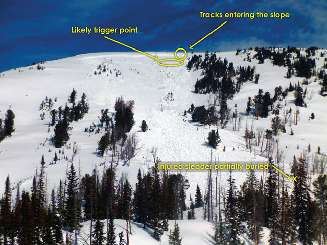
Two snowmobilers triggered a deep-slab avalanche on the south face of Mount Abundance north of Cooke City, Mont., on March 16, 2014. The avalanche injured and partially buried one snowmobiler. At top, the tracks of the snowmobiles entering the slope are visible. Credit: GNFAC.
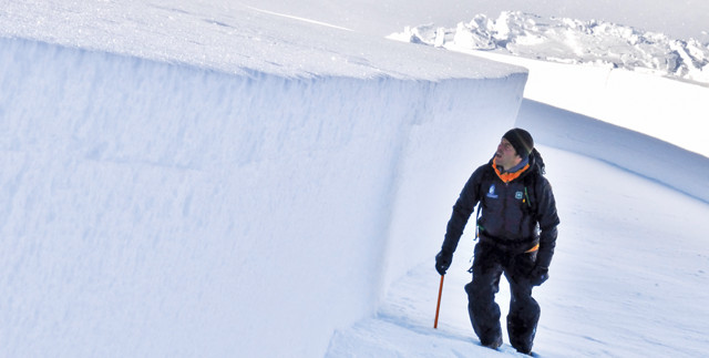
Karl Birkeland, who directs national efforts for the U.S. Forest Service’s 14 avalanche centers, has worn many hats over the course of his 30-year career in snow research. In 1990, he founded the Gallatin National Forest Avalanche Center in Bozeman. And in 1999, Birkeland co-founded the U.S. Forest Service’s National Avalanche Center, of which he became director in 2011. His role in this position is to link the theoretical with the practical by translating emerging research into the day-to-day practices of avalanche forecasters. In particular, he studies methods to characterize variability within the snowpack to help researchers, forecasters and skiers look for weaknesses in the snow and assess specific avalanche risks.
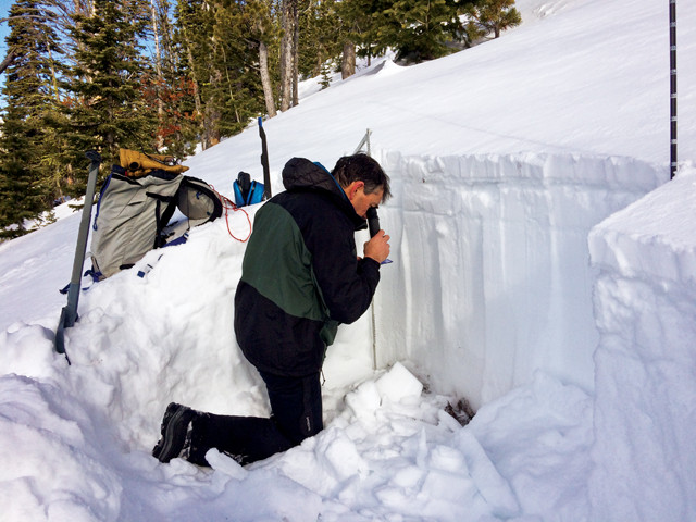
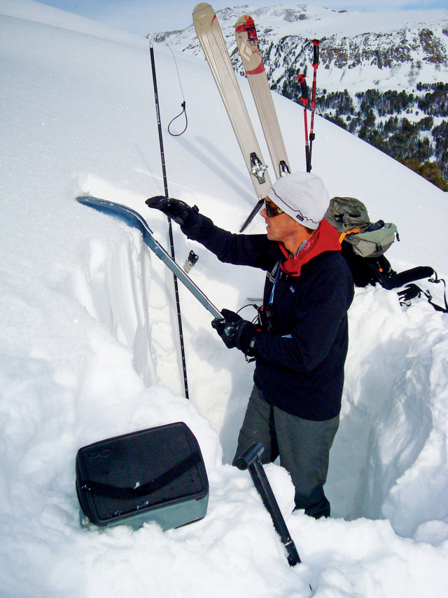
Like most avalanche researchers, Birkeland’s fieldwork involves digging snowpits — tidy square holes through the snowpack — to examine the layers in cross-section. The stability of the snowpack is assessed by isolating a column of snow and then tapping on it using your hand or a shovel with increasing levels of force until it fails. The number of taps the column withstands reveals its strength. More than 30 taps equates to robust strength. If the column fails after just a few taps, then the slope is likely on a hair trigger.
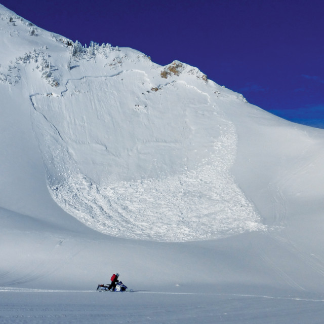
This avalanche was remotely triggered from low on the slope. One person (not the person shown here) was caught but not buried, but a snowmobile was buried. Credit: GNFAC.
An avalanche requires more than just an isolated pocket of weak snow; the failure has to spread or propagate across a wide area. This process is not unlike an earthquake, in which a relatively small initial break on a fault can lead a rupture to propagate along a larger segment of the fault. Propagation of snowpack failures is now an active research focus in snow science, Birkeland says.
Early snow dynamics researchers focused on the shear strength of snow, reasoning that on steeper slopes there was a greater force acting to pull apart the snowpack. Thus, snow stability tests, such as the compression test, were carried out on steep slopes where shear forces were high. This put researchers in danger and created a cumbersome protocol for skiers, who were advised to dig repeated snowpits as they ascended a slope.
Birkeland often leads avalanche classes in the Bridger Mountains. Above, he demonstrates the extended column test during an avalanche field class. Credit: both: Jordy Hendrikx.
In 2000 that began to change. Work by University of Calgary graduate student Crane Johnson, who is now a senior hydrologist with NOAA in Alaska, began to uncover another process at play. The shear model of avalanche initiation did not explain how an avalanche could be triggered on a gentle slope and create a failure on the slope above. This unexpected sequence of events has caused deaths of backcountry travelers who were situated on seemingly safe, low-angle slopes.
If shear strength were the main controlling factor, then avalanches should tend to start on the steepest slopes where the shear force was highest. Johnson used geophones to make the first measurements of how fast a fracture propagated through the snow, and his measurements showed that ruptures traveled through the snow slower than could be explained by shear failure. Johnson proposed that the driving force was a flexural wave in the snow overlying the weak layer. As the weak layer collapsed, it created a bending wave in the snow that caused the fracture to propagate outward from the initial break.
In 2004, another graduate student at the University of Calgary, Alec van Herwijnen, who is now at the Swiss Federal Institute for Forest, Snow and Landscape Research in Davos, used high-speed video of the wall of a snowpit to analyze the exact moments when failures occurred in a weak layer. This work confirmed that fracture speeds were too slow to have been caused by shear waves, and it further illuminated the two-step process of the collapse of the weak layer followed by the propagation of the rupture throughout the snow.
In his doctoral research, Joachim Heierli, now a postdoctoral researcher in materials science at the Karlsruhe Institute of Technology, formalized the idea that collapse and shear work together to drive snowpack fracture, rather than pure shear. In 2008, his work — presented in a seminal paper in Science — “changed the focus of how we’re all looking at the problem,” Birkeland says. One of the surprising predictions of Heierli’s model was that a weak layer in a snowpack will fail similarly on gentle and steep slopes.
Curious to test this hypothesis for himself, Birkeland went to Lionhead Mountain near Yellowstone National Park and dug a series of snowpits at varying slope angles, testing each one until the pit wall collapsed. Sure enough, the stability of the snow was the same, regardless of the steepness of the slope. “I couldn’t believe it,” Birkeland recalls, “so I went back out and repeated the tests all over again the next day.” The results were the same. “It was a game-changer for how we look at snow.” The implication is that scientists and forecasters can work in safer terrain and still get useful data about the snowpack strength and the behavior of weak layers. And skiers can learn about the terrain they intend to ski without venturing too far upslope.
With further refinement by Birkeland and colleagues, a new approach has trickled down into everyday user practice. The snow’s tendency to propagate a fracture, rather than absolute strength, is now seen as the main factor in characterizing snow stability. A new stability test, called the extended column test, helps users look for and gauge fracture propagation. It has become the accepted method for snowpack assessment, and education for professionals and recreational backcountry users has since been updated to reflect the emerging science, illustrating how leading-edge science disseminates from researchers to end-users.
Avalanche forecaster Doug Chabot examines snow crystals from individual layers within the snowpack. Credit: GNFAC.
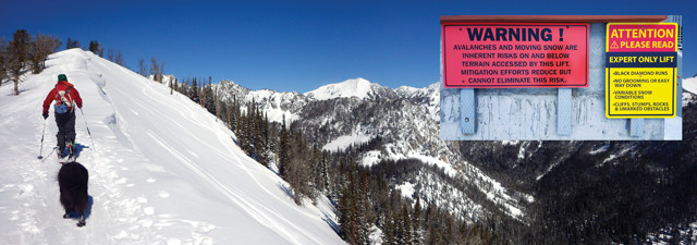
It is important for backcountry skiers and snowmobilers to take avalanche classes to learn how to assess snow stability. Here, avalanche forecaster Erik Knoff conducts a stability test, which is one tool for evaluating the likelihood of avalanches. Credit: GNFAC.
Clear and accurate communication of science to the public can be vital to public safety, especially when it comes to risk communication, where lore and misinformation often take precedence over scientific evidence. For example, many skiers assume that ski tracks on a slope indicate that the snow in that location is stable and safe. And yet many people have died while skiing slopes that had recently been skied by others.
Communication and education efforts are the mainstay of avalanche forecast centers. By stitching together information gathered from field tests and backcountry observations over a broad geographic area, and combining it with trends in weather and snow, forecasters can identify both levels of risk and the key factors causing the risk. A standardized, color-coded avalanche hazard rating scale, which ranks danger at five levels from “low” to “extreme,” is used throughout North America. Because snow stability varies with topography and geography, hazard ratings are often parsed by region or by type of landscape feature. For example, the danger can be rated as “considerable” on wind-loaded slopes, and “moderate” elsewhere. Forecast centers also craft daily advisories that fit relevant information into a few paragraphs of text as well as three-minute recorded messages.
Doug Chabot, director of the Gallatin National Forest Avalanche Center, says such messages have to be “accurate, timely and memorable.” He puts a lot of emphasis on creating a message that sticks with the user. “Someone who listened to the advisory at 7:30 that morning may not recall it by 1:30 in the afternoon when they’re standing on top of a great-looking powder slope.” So Chabot uses firsthand stories, videos and images to point out the important aspects of the hazard each day. In a recent video, Chabot described how the forecasters grappled with their own urge to ski a slope. The video shows Chabot standing in a snowpit, admiring the surrounding terrain. “This snow is just fantastic. It’s begging to be skied. I have to admit … I was thinking maybe we should ski it.” After relating to the emotion that many skiers feel, Chabot went on to demonstrate the weakness in the snowpack and why the hazard that day was subtle but serious.
The purviews of most avalanche centers span complex geographies and multiple mountain ranges, and addressing the spatial variability across such a large area can be challenging. “We assess the general hazard across the region, and then tell people what to look for in their particular location,” Chabot says. For example, his advice regarding buried surface hoar is simple and direct: “Put your shovel in the snow, dig down and look for a stripe in the snow. If you find it, go ski somewhere else.”
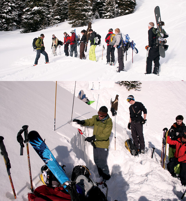
In the end, it is up to backcountry explorers themselves to practice snow safety. Credit: both: Mary Caperton Morton.
The daily advisories are only one piece of a comprehensive communications strategy. Avalanche centers also offer courses and workshops to build awareness and get people out into the field where they can learn about snow safety firsthand. “They need to get their hands and heads in the snow,” says Eric Knoff, a forecaster at the Gallatin National Forest Avalanche Center.
At Gallatin, the staff adjust the tone and content of their messages depending on the nature of the user group, such as skiers, snowmobilers, or adventure-seeking college students. Backcountry skiers typically cover limited amounts of terrain in a given day and can be taught to observe subtle changes within a smaller area. By contrast, snowmobilers travel quickly through large areas and are best served by looking for clear signs of instability, such as cracking or collapsing snow. College students, who often seem to see themselves as being invincible, frequently access untracked slopes just outside ski area boundaries, which they may do without much prior planning or assessment. For this audience, the educational message is simplified to basic protocol like avoiding steep terrain when the danger is high, traveling with a partner and carrying rescue gear. In each case, the educational message reflects the most common behaviors of that user demographic.
Chabot says the approach is working. Attitudes have shifted toward favoring more education and preparation, and the culture has become one where a honed sense of avalanche awareness is the expected norm. The data are encouraging: While participation in winter backcountry sports is sharply increasing, accidents and fatalities are not. The extreme skiing that Tom Jungst and his peers pioneered several decades ago will always be a daring pursuit, but it is now made safer by an entire scientific discipline striving to understand the hazard and prevent unnecessary risks.
© 2008-2021. All rights reserved. Any copying, redistribution or retransmission of any of the contents of this service without the expressed written permission of the American Geosciences Institute is expressly prohibited. Click here for all copyright requests.