
by Brian Fisher Johnson Thursday, January 5, 2012
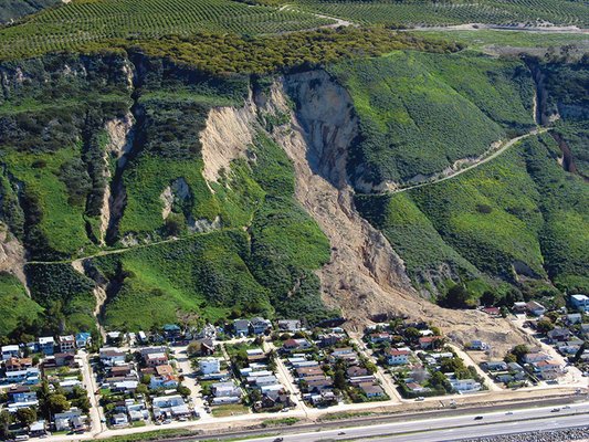
Part of a previous landslide deposit remobilized and struck the community of La Conchita, Calif., on Jan. 10, 2005. Mark Reid, USGS
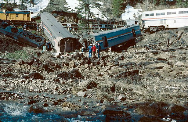
A landslide in April 1985 near Granby, Colo., derailed this Amtrak train. Robert L. Schuster, USGS
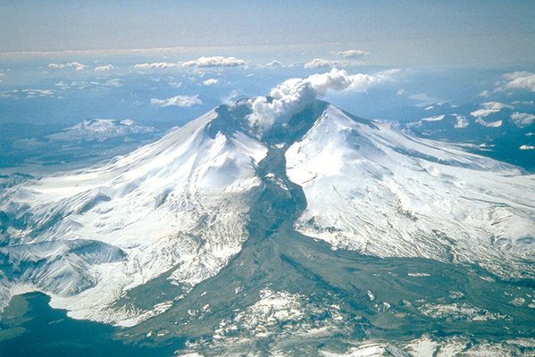
Volcanoes can also be sources of landslides called lahars. This lahar formed after a1982 Mount St. Helens eruption in Washington state. Tom Casadevall, USGS
Feb. 5, 2010: A landslide in Maggie Valley, N.C., damages three homes after wet weather destabilizes the mountainside. No one is injured, but officials must dig out one family from its home. Feb. 6, 2010: A storm causes landslides in La Cañada Flintridge, Calif., damaging at least 43 homes. The event is set off by heavy winter rains that hit hillsides already denuded of vegetation by wildfires the previous summer. Feb. 6, 2010: City officials evacuate 11 families from their homes in Wheelwright, Ky., a month after a landslide began slowly ripping apart the hillside. City officials suspect water buildup in an abandoned mine acted to wet the soil, although tests by the Office of Surface Mining have shown no link between the mine and water in the hillside.
According to the U.S. Geological Survey (USGS), landslides affect all 50 states in the United States and its territories. On average, they kill more than 25 people every year, costing $1 billion to $2 billion in damages.
Scientists have a good understanding of the causes and mechanisms of landslides. And with the help of engineering, people can even live in landslide-prone areas without immediate fear of sliding downhill. But implementing policies surrounding landslide risk is not so simple — owing both to politics and science.
Landslides generally happen when either heavy rain or shaking from earthquakes pushes slopes over the edge. They fall into two general categories: deep-seated and shallow.
Deep-seated landslides generally occur when water or ground shaking causes a slope to slip along a plane of weakness within the underlying bedrock — usually a fault or the bedding surface between two sedimentary layers, says David Montgomery, a geomorphologist at the University of Washington in Seattle. These landslides tend to affect whole hillsides, taking entire neighborhoods down with them, he says. And although these landslides can move quickly, Montgomery notes that they tend to move relatively slowly compared to shallow landslides — only a meter to several meters per year.
That kind of movement can still crack foundations and destroy houses, Montgomery says — but at the very least, inhabitants are often alerted to the hazard in time to escape. An example of a deep-seated landslide in action includes some of the neighborhoods of North Berkeley, Calif., he says. “The houses are literally surfing down the hill — but they’re doing it very slowly.”
Shallow landslides, on the other hand, happen when the soil and sometimes weathered rock above bedrock slides downhill — often due to rain or other water supplies that infiltrate the soil until it begins to flow. They tend to move fast — up to about 50 kilometers per hour. And it’s these landslides, Montgomery says, that are most prone to taking lives. On the morning of Oct. 8, 2008, for example, a woman barely escaped from her home in Portland, Ore., after it began slipping downhill in such a landslide. Neighbors were able to pull her to safety with a ladder, but 20 minutes later, her house was destroyed.
Geologists have learned ways to identify areas at risk for landslides. An important hint in locating where deep-seated landslides might occur in the future, for example, is identifying where they have occurred in the past. Fortunately, these events leave a distinct mark on topography, says Bill Burns, an engineering geologist with the Oregon Department of Geology and Mineral Industries in Portland: concave scarps at their tops, distinct depressions in their middle sections and steepened areas at their toes. All the while, technologies such as light detection and ranging (LiDAR) are giving geologists a new perspective in scoping out landslide risk by revealing detailed images of topography even beneath forests.
Going by past events doesn’t work as well with shallow landslides, Montgomery says; once the soil slides downhill, it can take hundreds of years for enough soil to re-accumulate on that site and set up the next landslide event. Still, he says, geologists can spot areas of concern by looking for convergent topography: places where steep valleys and small headwaters focus water drainage, increasing the water levels in soils until the slopes fail.
But in other ways, landslides remain a bugbear among natural hazards. That’s because unlike flood or earthquake risk, landslide risk is highly local and varies across a landscape. “With flood hazards you sort of get a broad brush. You get this big area of flat land by the river” that is all at high risk for flooding, Montgomery says, “whereas with landslides … you need a finer-scale brush.”
What’s more, landslide risk is not only spread out spatially, but also over time. “A whole region is not going to go down at once like in an earthquake,” Montgomery says. “If you have 10,000 spots on a landscape susceptible to sliding, and they all go at a pace of once every 2,000 years, then … you’re still talking low probabilities of individual events,” he says. “But if you integrate across the landscape, it’s a high probability … It’s like death by a thousand cuts rather than getting your head cut off.”
Unfortunately, the unique nature of landslides makes it harder for scientists to apply their knowledge about this natural hazard, and therefore, makes it challenging to help people mitigate the risk.
Stitched into the western face of the Appalachian Mountains, Kentucky has its fair share of landslides. According to the USGS landslide overview map of the United States, the entire southeastern end of the state experiences a “high” incidence of landslides, meaning more than 15 percent of the region has experienced landslides. Transportation agencies in the state have encountered some 3,000 individual landslide events since the early 1970s, according to the Kentucky Geological Survey — not including the thousands of other landslides that don’t affect roads.
The state is taking measures to get a better handle on the scope of its susceptibility to landslides, according to William Andrews, head of the geologic mapping section of the Kentucky Geological Survey in Lexington. The survey has begun keeping a database of landslide events. It is also mapping sediment and soil deposits with the help of LiDAR data from other agencies in the hopes of revealing something about landslide susceptibilities throughout Kentucky.
But progress is not as simple as collecting data. Some county officials are less than thrilled with the idea of landslide hazard maps, according to Andrews. “If a county official thinks their collective property values will get devalued or that development is discouraged, they’re not going to want details advertised.” That has a special resonance in eastern Kentucky, Andrews says, which is economically distressed. “We’re trying to carefully navigate people’s caution and people’s concerns,” he says.
Moreover, Andrews says, most Kentuckians remain unaware of scientists' ability to spot areas of high risk, often perceiving landslides as a random act of God. “They know it happens,” he says, “but the idea that you can identify, in advance, areas that are more susceptible than others is not being actively applied right now.”
Across the Appalachians at the North Carolina Geological Survey in Asheville, efforts by senior geologist Rick Wooten and his colleagues to raise awareness of high-risk areas for landslides also face complications. Since 2005, the survey has been mapping landslide risk across North Carolina with funding from the state legislature. With the aid of LiDAR, it has completed GIS maps for three counties. These maps can be posted on the Internet, but so far, Wooten says, only one of the three counties has made its GIS map available online.
There had been moves within the state legislature to require the disclosure of available landslide hazard maps during land transactions, Wooten says. But that legislation was strongly opposed by homebuilders and realtors associations in the state. Their concern, among other things, was that the print versions of these GIS landslide hazard maps were at too broad a resolution; translating GIS maps to print sacrifices scale, making it difficult for developers and homeowners to know for certain whether their property falls within an area of high risk based on the print maps. “In a lot of counties in western [North Carolina], GIS isn’t available or isn’t easily available, hence the problem,” says Lisa Martin, director of government affairs with the North Carolina Home Builders Association in Raleigh.
Martin says the association supports landslide hazard mapping — as long as the maps are at a sufficiently high resolution to identify individual parcels. “We need to approach this systematically,” she says.
In California, where landslides also pose a threat, landslide risk is a consideration in development and real estate transactions, says Tim McCrink, a senior engineering geologist with the California Geological Survey in Sacramento: For example, local jurisdictions and counties are required to consult seismic hazard maps before they issue permits for construction. But unless a past landslide falls within a seismic hazard zone, developers may not necessarily be required to investigate or address it in their county.
McCrink says he’d like to see landslide inventory maps fully incorporated into the real estate and development process throughout California. But he understands why some homeowners might protest the disclosure of their property’s landslide history. “Just because a particular geologist identifies an area where a landslide has occurred in the past does not mean that particular landslide is ever going to move in our lifetime,” he says. “There are too many details that are unknown.”
Andrews and Wooten agree that in an ideal world, landslide hazard maps
would be disclosed during development and land transactions. That may
not happen anytime soon given the complexities surrounding landslides as
a hazard, but geologists do have arguments that speak in their favor.
Bill Burns notes that hazard maps are not just about pointing out where
landslide hazards exist, but illuminating where landslide hazards do
not. McCrink agrees: “If you look at them as good news maps, you don’t
have to worry about those hazards in certain areas.”
Indeed, the intricate nature of landslide hazards is in fact what allows for economic development in an overall landslide-prone region, Andrews adds. “What I would argue is that some parts of any slope are better than other parts of the same slope, and so there are a lot more … subtle, very localized decisions that can be made to allow successful economic development even in what is regionally a high-risk area.”
At the same time, waiting for detailed parcel-level or site-specific hazard maps everywhere is not practical, Wooten notes. “We can map and map in a county for 10 years, and that would never be a substitute for a site-specific investigation by qualified professionals,” he says, adding: “The mapping we do [in North Carolina] is a screening tool to identify and narrow the field to those areas where such site-specific investigations are warranted for slope stability reasons prior to development.”
Wooten knows the importance of personally investigating sites. With the aid of aerial photography and LiDAR, he and his colleagues can spot landslide warning signs, such as debris fans — accumulations of outpoured debris left at the end of a typically shallow, soil-based landslide called a debris flow, which comprises most of the landslides that strike North Carolina. But sometimes these features aren’t so obvious, especially in an area that doesn’t seem steep enough to be landslide-prone. In cases like these, Wooten says, it pays to visit a site personally.
Once there, geologists may determine that the upslope areas have lost enough steepness through erosion since the debris fans were deposited that landslides no longer pose a substantial risk. Or, Wooten says, his team may discover that the “debris fan” they spotted from the air was actually a solid rock formation, sticking out in a fan shape after the area around it eroded.
At the same time, other factors may suggest the site is still at risk of landslides. For example, slopes above 20 degrees tend to face a higher risk, Wooten says. Other factors, such as the presence of silt in soil (which tends to absorb water) and mosses and ferns (water-loving plants that indicate a site is already soaked with water) could suggest a site is predisposed to landslides. Once such factors are measured, Wooten’s team enters them into a GIS-based computer model, which ranks the susceptibility of a site to sliding on a scale ranging between “stable” and “unstable.” The models can also estimate how far a future landslide might spread down a slope. “In the course of mapping a county, we try to visit as many actual landslide sites as we can,” Wooten says.
And so, just as hillsides fail slope by slope, geologists continue to evaluate landslide risk slope by slope.
© 2008-2021. All rights reserved. Any copying, redistribution or retransmission of any of the contents of this service without the expressed written permission of the American Geosciences Institute is expressly prohibited. Click here for all copyright requests.