
by Adityarup "Rup" Chakravorty Tuesday, May 1, 2018
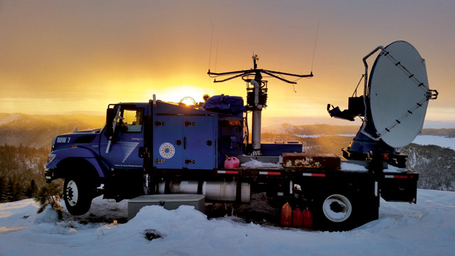
A "Doppler on Wheels" truck, equipped with X-band radar, atop Packer John Mountain in the Salmon River Range in central Idaho tracks the formation of ice particles during cloud seeding experiments. Credit: Josh Aikens.
Cloud seeding — adding particles to clouds to modify precipitation patterns — has been suggested as a way to trigger rain and snowfall, which could help sustain mountain snowpack and water supplies across the western U.S. However, it has been challenging to demonstrate the technique’s effectiveness and efficiency, in part because direct observations of the full chain of events involved in cloud seeding have been lacking.
In a new study in Proceedings of the National Academy of Sciences, researchers report observations of the entire sequence of a cloud seeding cycle: from introducing silver iodide particles into clouds to the nucleation of ice crystals to the resulting precipitation hitting the ground.
“We were able to confirm — under specific circumstances — the basic hypotheses of what physically happens when you put seeding material into a cloud,” says Jeffrey French, an atmospheric scientist at the University of Wyoming and lead author of the new study. “Bits and pieces of this process have been observed before, but never the entire sequence.”
French and his colleagues used a combination of airborne and ground-based instruments to study cloud seeding experiments over the Payette Mountains in southwestern Idaho, about 80 kilometers north of Boise, as part of the National Science Foundation-funded Seeded and Natural Orographic Wintertime Clouds – Idaho Experiment, or SNOWIE.
Clouds in the study area are usually orographic, formed by air rising over the mountains. Orographic clouds contain supercooled water droplets, which are smaller than a quarter of a millimeter in diameter, and have correspondingly small radar signatures. Ice crystals, in contrast, can be several millimeters in diameter, with radar signatures up to a thousand times larger than those of supercooled water droplets, which gives researchers a clear way to distinguish the two.
During the study, a seeding aircraft, flying roughly perpendicular to the wind direction, navigated back and forth through naturally formed clouds, introducing silver iodide particles at specific time intervals. Simultaneously, a measurement aircraft equipped with sensors to detect the effects of the seeding flew perpendicular to the other plane’s flight path and parallel to the wind direction.
The researchers also monitored the experiment with two ground-based stations equipped with X-band radar, which uses relatively long wavelengths that allow measurements to be made from tens of kilometers away, providing a broad view of the cloud seeding results.
“But greater range comes at the expense of sensitivity,” French says. To compensate, the measurement aircraft carried a W-band radar system, which uses shorter wavelengths that provide greater measurement sensitivities at ranges of 1 to 2 kilometers.
Shortly after seeding, the ground-based radars detected discrete bands of increased radar reflectivity downwind of the seeding flights, indicating ice crystals were forming in the clouds. Outside these bands, the measurement aircraft detected tiny liquid water droplets but no ice crystals.
When the aircraft passed through developing bands of high radar reflectivity, it detected significantly lower levels of liquid water than in areas outside the bands. The team also found evidence of ice crystals up to 1 millimeter in diameter — evidence that water droplets were turning into ice crystals. On subsequent passes through these bands, they observed ice crystals as large as 8 millimeters across.
Eventually, the bands of increased reflectivity stretched from the clouds to ground level, indicating that the ice crystals were falling as snow.
“This study provides the best evidence so far about what happens after silver iodide particles are introduced into clouds,” says Daniel Rosenfeld, an atmospheric scientist at Hebrew University of Jerusalem, who was not involved in the study. That’s important, Rosenfeld says, because without concrete evidence of the mechanisms involved, there has been “much skepticism and a lack of funding from governments to study cloud seeding.”
“We haven’t yet shown whether cloud seeding leads to increased snowfall [on a broader scale],” French says. But this study will help answer that question, he says, because it provides a methodology to gather more quantitative data about the different stages of cloud seeding, which can be used to develop better numerical models of the process. “Ultimately, we could use these models to assess the broader question of whether we can meaningfully impact rain or snowfall over the course of a season within an area using cloud seeding.”
Rosenfeld agrees, but points out that the physical results of the seeding experiments in this study may not apply everywhere. “The atmospheric conditions in southwestern Idaho are somewhat distinct, as shown by the relatively small numbers of droplets and crystals in the clouds before seeding,” he says. “Other areas, those with urban settlements or more industry, for example, will have more aerosols in the atmosphere, some of which may [already] act to create ice as cloud seeding does.” Therefore, it remains unclear how effective cloud seeding efforts would be in those areas.
© 2008-2021. All rights reserved. Any copying, redistribution or retransmission of any of the contents of this service without the expressed written permission of the American Geosciences Institute is expressly prohibited. Click here for all copyright requests.