
by Jennifer Georgek Friday, April 24, 2015
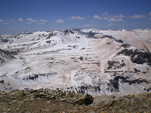
By mid-century, many parts of the Colorado Rockies, and elsewhere across the western U.S., once dominated by snow will see precipitation falling mostly as rain, according to recent research. Credit: T. H. Painter, Snow Optics Laboratory, JPL/Caltech
Gauging the impacts of climate change on future precipitation is challenging, especially in the western U.S., a region with highly variable temperatures, precipitation patterns and terrain. But understanding such impacts in the West — and, in particular, how much precipitation will fall as snow versus rain in the future — is important given the region’s dependence on wintertime snowfall as a freshwater resource. Now, a new study forecasts a broad shift from snow to rain for much of the West — a projection that will require attention from land and water resource managers planning for the future.
Normally, the western snowpack acts as a vast natural reservoir. However, “if precipitation is falling as rain, it runs off into our rivers … decreasing our capability to store it naturally,” says Anne Nolin, a hydrologist at Oregon State University who was not involved with the new study. As a result, she says, “we’re forced to rely on our artificial storage, such as reservoirs, many of which aren’t really constructed for long-term storage.”
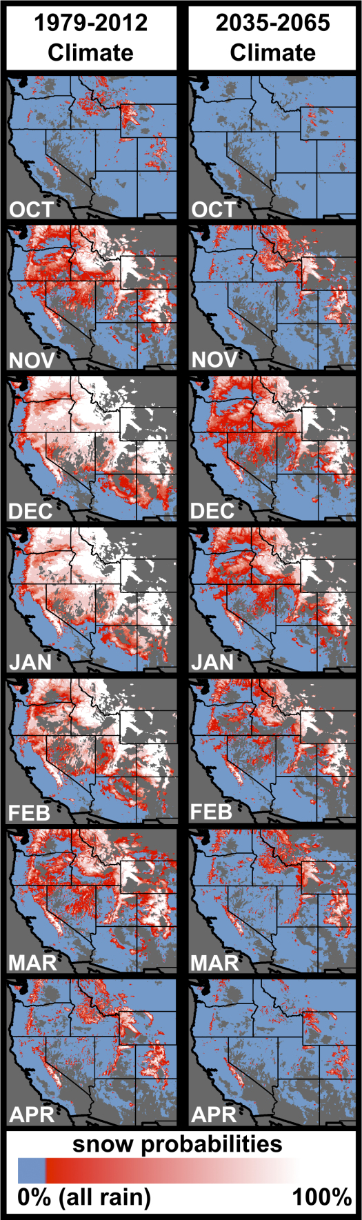
Rain-dominated (blue) versus snow-dominated (white) areas in the current and predicted future climate of the U.S. West. Credit: P.Z. Klos et al., 2014, Geophyiscal Research Letters
In the new research, published in Geophysical Research Letters, Zion Klos, a water resource scientist at the University of Idaho, and colleagues modeled the spatial extent of the rain-snow transition zone, the swath of land surface separating areas where precipitation is mostly liquid versus mostly frozen. In the past, the location of this zone has been determined based on long-term temperature and precipitation data from climate monitoring networks spread around the West, which scientists have used to forecast the type of precipitation that will likely accompany projected climate change.
However, unlike in previous studies, which used the full temperature records, Klos’ team only used temperature data from days when more than 5 millimeters of precipitation fell. This distinction is important, Klos says, because “it prevents a cold bias” in the data. Dry days tend to be clear and relatively cold because of the lack of moisture in the atmosphere, which, when present, traps heat and radiates it back toward Earth’s surface. Predicting precipitation phases based on temperature averages that include both wet days and dry days is thus likely to skew predictions toward snowier conditions.
For the period between 1979 and 2012, the team found that much of the mountainous western U.S. — in the Cascades, Sierra Nevadas and the high Rockies, for example — experienced 100 percent of its precipitation as snow from December to February. Not surprisingly, in the warmer fall and spring months, the snow-dominated area shrinks, with rain creeping to higher elevations.
Klos and his colleagues also modeled future changes in the rain-snow transition zone for the western U.S. from 2036 to 2065. Based on the historical data they’d compiled, the researchers correlated wet-day temperature projections from 20 different climate models to precipitation phase. The results revealed a general shift in the rain-snow transition zone to higher altitudes and latitudes, decreasing the average wintertime snow-dominated area from about 53 percent of western lands to 24 percent.
The team’s modeling suggests that snow will continue to dominate many high mountain regions, especially in the Sierra Nevadas, the Colorado Rockies and western Wyoming, during the winter months. However, other areas once dominated by snow from November through March, including large portions of Washington, Oregon and northern Nevada, will likely experience an increasing proportion of rain by the mid-21st century, with the most substantial changes expected in March and April.
In addition to quantifying broad regional changes, the team also looked at precipitation changes on finer scales, such as at the watershed level. Data from this effort — publicly available in the form of detailed maps — will be important for future precipitation assessments, Klos says. And these results will help inform “water resource managers, winter recreationists and people who are worried about snowpack development for ecological reasons,” he says. For example, Klos says, “water managers can better plan for future changes in the timing and availability of the flow they need for downstream hydropower, irrigation and in-stream uses.”
The mid-century predictions for precipitation change presented in the study are based on some of the more extreme projections of climate impacts, Nolin says, so the changes suggested might be greater than what will actually occur. Or, she adds, considering the snow drought in recent years, they could well be on target. The researchers “are also looking farther into the future than a lot of managers [plan] for,” Nolin says. Land and water resource managers tend to look 10 to 20 years out at a time, she says, not 50 years. “Fifty years is almost too long of a management timeline … but, that doesn’t mean it’s not important” to anticipate longer-term changes.
© 2008-2021. All rights reserved. Any copying, redistribution or retransmission of any of the contents of this service without the expressed written permission of the American Geosciences Institute is expressly prohibited. Click here for all copyright requests.