
by Mary Caperton Morton Thursday, January 17, 2019
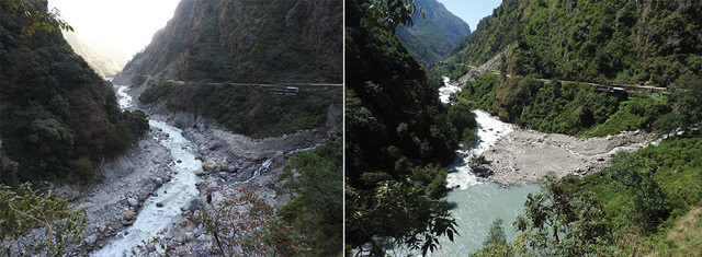
The Bhotekoshi Valley in Nepal before and after the 2016 flood of the Sunkoshi River. Credit: both: Kristen Cook/GFZ.
On July 5, 2016, a previously dammed glacial moraine in Nepal burst, releasing 100,000 tons of water that barreled down the Sunkoshi River, destroying bridges, hydropower plants and roads in its path. The flood was so massive that ground shaking was felt throughout the river corridor and recorded by seismometers deployed in the wake of the April 2015 Ghorka earthquake.
The event is the first glacial outburst to be recorded by instruments in such close proximity and at high resolution, researchers led by Kristen Cook, of the GFZ German Research Center for Geosciences, wrote in Science. “We could identify two distinct pulses” of shaking, Cook said in a statement. The first came from the wall of water, with the other following seconds later as rocks and coarse sediment dislodged by the floodwaters crashed through the corridor, triggering a wave of landslides along the steep river banks.
The Himalayas are home to thousands of glacial lakes, many of which are at risk of similar flooding events, the team wrote. Although relatively rare, such floods may play a more significant role in driving regional erosion than the floods triggered by annual monsoon rains, as glacial floodwaters can mobilize larger quantities of boulders, rocks and coarse sediments than rainfall floods, leading to more landslides and large-scale erosion. “Erosion rates can be strongly influenced by nonclimatic factors such as earthquakes,” the researchers wrote, as well as climate-linked factors that affect the size and distribution of flood-prone glacial lakes.
© 2008-2021. All rights reserved. Any copying, redistribution or retransmission of any of the contents of this service without the expressed written permission of the American Geosciences Institute is expressly prohibited. Click here for all copyright requests.