
by David B. Williams Thursday, February 20, 2014
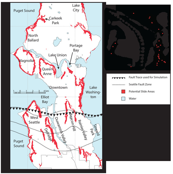
This Seattle area map shows the location of the Seattle Fault Zone (dotted line), the fault location used for the rupture model for landslide simulation (line of triangles), and landslide-prone areas designated by the city. The inset map shows the regional tectonic setting and volcanoes (triangles). Allstadt et al., BSSA 2013 ©Seismological Society of America
Landslides have been part of Seattle’s history “from a time to which the memory of man runneth not back,” wrote famed city engineer Reginald Thomson in 1897. A new study shows that landslides will also play a central role long into the future. They will be “extensive and potentially devastating, causing direct losses and impeding recovery,” reported a team in Bulletin of the Seismological Society of America.
With steep slopes, unconsolidated soils and high rainfall, Seattle is primed for landslides. The city is also threatened by at least three different types of earthquakes — Benioff zone quakes in the subducting Juan de Fuca Plate, megathrust quakes in the coastal Cascadia subduction zone, and shallow quakes in the North American Plate — making it one of the most susceptible cities to landslides in the country. Lead author Kate Allstadt, a doctoral candidate in seismology at the University of Washington and her colleagues created a new model to better understand future landslide risks in the city.
Allstadt’s team focused specifically on the Seattle Fault Zone because it has the greatest potential for damage. The 40-kilometer-long zone runs east-west from the eastern edge of Bainbridge Island through the southern end of downtown Seattle, continuing east beneath Lake Washington and Lake Sammamish. The fault’s last movement 1,100 years ago caused three groves of massive trees to slide into Lake Washington and led to rock avalanches in the Olympic Mountains, as well as a tsunami in Puget Sound.
The new model uses the Newmark method, which factors in slope geometry, soil properties and groundwater conditions. Although the methodology isn’t perfect, Allstadt says, it is the best available for a citywide survey. Plus, she notes, recent increases in computing power allowed the team to make more detailed analyses than had previously been made for the Seattle area. The new study, she says, generated the first broadband synthetic seismograms of Seattle, which incorporate both low- and high-frequency wave propagation. This is especially important in Seattle because of its shallow, unconsolidated soils and because the metropolitan area sits in a basin, which “amplifies ground motion, generates strong basin surface waves, and tends to increase the duration of shaking,” the authors wrote. If the study didn’t incorporate the broadband synthetics, their analysis would fail to show the full effect of Seattle’s complicated geology, Allstadt says.
To take into account Seattle’s rainy climate, the researchers ran two scenarios, both based on a 3- to 15-kilometer-deep fault, with a 45-degree rupture dip. The dry soil run generated 4,977 landslides, covering 0.1 percent of the city’s total land area. Sliding would affect more than 1,000 buildings with twice as many hit by slide runouts. For saturated soils, the results were “more drastic,” they reported, generating nearly 31,000 landslides, or 0.8 percent of the land area. In these conditions, more than 8,000 buildings are in the hazard zone and another 8,500 in the runout zone. Allstadt notes that the latter scenario is highly unlikely because it is based on a low-probability earthquake occurring with higher than normal seasonal rainfall, followed by intense precipitation.
What makes the study valuable for hazard managers is the extent to which the predicted landslides are outside areas known to be prone to landslides. Although 66 percent of historical landslides lie within zones predicted in the dry run and 80 percent in the saturated conditions, existing landslide hazard maps are based primarily on slope and soil conditions. “Clearly, these maps are not adequate to delineate areas likely to produce landslides during the earthquakes,” the authors wrote.
One challenge with the study is that it is a computer model and not a real world study, says Tim Walsh, chief hazards geologist for the Washington Department of Natural Resources. Nonetheless, he says, “for us this broadens the universe of hazards analysis. [The team] has developed a cutting-edge technique, but it will need further testing before we can apply the work to new hazards maps.”
© 2008-2021. All rights reserved. Any copying, redistribution or retransmission of any of the contents of this service without the expressed written permission of the American Geosciences Institute is expressly prohibited. Click here for all copyright requests.