
by Bethany Augliere Thursday, January 19, 2017
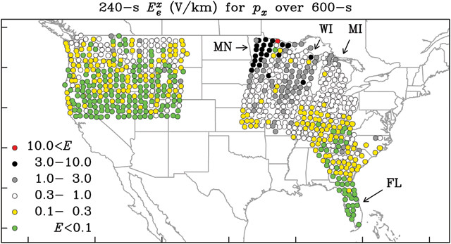
Geoelectric hazard map showing the amplitude of geoelectric fields expected to occur once per century on average. Red, black and gray are areas of high hazard; white, yellow and green are areas of low hazard. Credit: Love et al., Geophysical Research Letters, September 2016.
During solar storms, electrons and protons collide with Earth’s atmosphere, disrupting the geomagnetic field and sometimes creating the flashing waves of colorful light in the night sky we know as auroras. But these same storms — if strong enough — have the potential to severely damage power grids.
In a new multiagency study led by the U.S. Geological Survey (USGS), scientists created the first map of geoelectric hazards; the map covers about half of the continental United States and was initiated by the White House’s National Science and Technology Council in 2015.
“During a magnetic storm, you can get this beautiful manifestation of nature, but magnetic storms can also be hazards,” says Jeffrey Love, a geologist with USGS in Denver, Colo., and lead author of a study in Geophysical Research Letters presenting the maps.
Love’s team mapped geoelectric fields that are likely to occur during intense magnetic storms about once per century. “They’re rare,” Love says, “but have happened in the past.” The researchers used a combination of historical monitoring data from magnetic observatories and magnetotelluric survey data, which measures the relationship between electrical and magnetic energy in Earth’s subsurface.
The electric field strength was not uniform over the area studied, which included parts of the Northwest, Midwest and Southeast, and varied by region and with the conductivity of the lithosphere below, Love says. The greatest threat to power grids was inferred in the upper Midwest, such as in Minnesota and Wisconsin, where strong electric fields could potentially develop due to properties of Earth’s lithosphere. Florida had the lowest hazard.
The team plans to expand their surveys across the rest of the U.S. Currently, researchers are working in regions like the Northeast to study areas with large population centers and complex power grid infrastructures, Love says. “We just need to expect that our utility companies and the government will work together constructively to make sure to address this hazard.”
© 2008-2021. All rights reserved. Any copying, redistribution or retransmission of any of the contents of this service without the expressed written permission of the American Geosciences Institute is expressly prohibited. Click here for all copyright requests.