
by Adam DiFrisco Tuesday, April 15, 2014
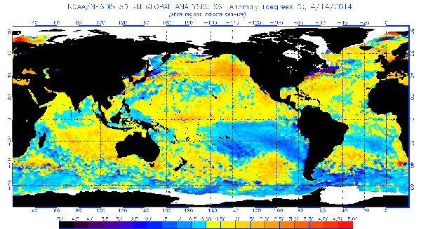
The reds in this band show the general areas of sea-surface temperatures that affect the formation of an ENSO event. Anomalously warm temperatures in the equatorial Pacific tend to indicate an El Nino event; anomalously cool sea-surface temperatures in that region tend to indicate a La Nina event. Credit: NOAA.
Whether it be the two monsoons that wiped out Kublai Kahn’s conquest of Japan, or the fog in Long Island that allowed George Washington and his troops to escape with their lives, the predictability of the weather (or lack thereof) has left its mark on human civilization. Of all climate and weather phenomena, the El Niño Southern Oscillation (ENSO) is one of the most well known for its impact on world climate and human life, but is also one of the most puzzling to scientists. Recently, researchers have begun accounting for a much more global dataset than previously considered in the hopes of predicting El Niño or La Niña conditions sooner than is currently possible.
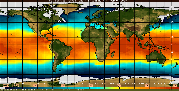
As of early April, the equatorial Pacific was showing slightly anomalously warm temperatures (red), indicating a potential El Nino. Credit: NOAA.
Currently, El Niño or La Niña conditions can only be accurately predicted about six months out. But this six-month window of prediction can be troublesome, says Avi Gozolchiani, a postdoctoral researcher at Bar-Illan University in Ramat-Gan, Israel, and a co-author of the new study on ENSO prediction, published in Proceedings of the National Academy of Sciences. When scientists issue a six-month prediction, they are predicting the crossing of a threshold in sea-surface temperatures; however, by the time this prediction is affirmed, El Niño’s initiation phase has already begun, Gozolchiani says. “So actually, six months is when the thing already starts to happen,” and ideally, “you want to know what will happen next year before the initiation phase.”
Traditional ENSO prediction involves using physical and statistical models to identify patterns and cycles in the El Niño Basin — an area from roughly the coast of Peru to about halfway across the Pacific Ocean. The approach taken by Gozolchiani and his team involves looking much farther afield, using a “network analysis” in which the researchers track not only atmospheric temperature data points inside the El Niño Basin, but also temperatures at points extending from Cuba to Australia and most of the Pacific as well. After all points inside the basin are linked to those outside it (creating a vast network of links) the data are applied to an algorithm to create a prediction scheme.
Generally speaking, everyone knows that “this place is connected to that place,” says Shlomo Havlin, also a physicist at Bar-Ilan University and co-author of the report. But seeing the connectivity — following a network and seeing how it evolves in time — is the key, Havlin says.
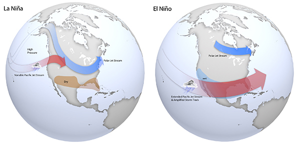
Maps of typical jet stream locations and patterns during La Niña (left) and El Niño (right) winters. Credit: Climate.gov, based on original graphics from NOAA's Climate Prediction Center.
Once they established links, the team then looked at the strength of all individual links at a single moment in time and calculated the “mean link strength” — an average of all the individual links in the network at a given point in time. They hypothesized that each time the mean link strength crossed a certain “decision threshold,” which is given by the algorithm, an ENSO event would take place the following year, they reported. To check their model, the team plugged in historical data going back to 1981 and found that 76 percent of the alarms issued by the model (when the mean link strength crossed that threshold) successfully matched actual past ENSO events. Other models that attempt to predict ENSO events a year ahead generally run at 40 to 50 percent accuracy, Havlin says.
“In terms of data quality,” the new study is “good, and I’m sure it’ll be a great contribution to ENSO prediction,” says Eungul Lee, a climatologist at West Virginia University. “ENSO prediction is the most important signal in global climate,” Lee says. Forecasting a year in advance could have major implications on the preparations of affected countries, he says.
The system can be put to the test this year. As of September 2013, according to the new research, the decision threshold was crossed again, indicating a return of El Niño in 2014. And earlier this month, traditional forecasts have also indicated a greater than 50 percent likelihood of an El Niño forming.
© 2008-2021. All rights reserved. Any copying, redistribution or retransmission of any of the contents of this service without the expressed written permission of the American Geosciences Institute is expressly prohibited. Click here for all copyright requests.