
by Bethany Augliere Monday, October 17, 2016
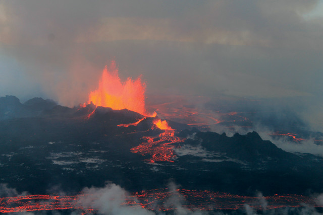
Scientists monitored the 2014 caldera collapse of Iceland's Bárdarbunga Volcano in real time. Pressure from the caldera collapse allowed magma to continue flowing in a dike underground until it finally erupted in fissures in the Holuhraun lava field. Credit: Peter Hartree, CC BY-S.A 2.0.
Many of the most catastrophic volcanic eruptions in history have something in common: caldera collapse — the formation of a large hole by the collapse of a volcano’s peak associated with the emptying of the magma chamber. But these events are rare. So, in August 2014, when Bárdarbunga Volcano in central Iceland erupted, it gave scientists the unique opportunity to study a caldera collapse in real time.
Magnus Gudmundsson from the University of Iceland led a team of 47 experts from 14 universities and nine countries to study and document the event in unprecedented detail. The findings, published in Science, answered a long-standing mystery of whether eruption drives caldera formation, or the collapse triggers the eruption. At Bárdarbunga, the collapse drove the eruption.
The record-breaking eruption was the largest in Europe since the Laki eruption in 1783, and — in terms of the size of the area — the largest caldera formation ever observed, covering roughly 110 square kilometers and eventually sinking 65 meters deep. “It’s a landmark study, it’s a landmark eruption,” says John Stix, a volcanologist at McGill University in Quebec, Canada, who was not involved in the new research. “I think it — the Bárdarbunga eruption — will definitely go down in the annals of volcanology. Everybody will remember this.”
Bárdarbunga lies beneath the 500-meter-thick Vatnajökull Ice Cap. So, scientists across disciplines worked from aircraft and on the ground to study the event. From aircraft, glaciologists measured changes in surface ice movement with radar altimeter surveys and made maps using satellite imagery. With these observations, the scientists produced 3-D models of the ice flow. Seismologists and geophysicists used helicopters to place GPS sensors atop the ice at the center of the caldera to study deformation of the ground. Geochemists used geobarometers to analyze the volcanic gas and lava chemistry to determine the depth of the magma.
“By combining all this, we got as comprehensive a picture of how all this happened as I think is possible with the present knowledge and technology,” Gudmundsson says.
But it wasn’t always easy. Working from helicopters and snowmobiles in the middle of the Icelandic winter was a challenge, with just six hours of daylight, high winds and frequent cloud cover, he says. “You need very experienced technicians and tough expedition people who can do these trips.”
Together, the scientists pieced together a story that fit all the data, Gudmundsson says.
On Aug. 16, 2014, the magma reservoir under the volcano — which was surprisingly deep at 12 kilometers beneath the ice — started to rupture as it set off a series of earthquakes. A dike began forming belowground, as magma flowed southeastward 7 kilometers. The dike then turned 90 degrees and propagated another 41 kilometers northeastward, about 6 to 10 kilometers belowground. About five days after magma began flowing through the dike, the roof above the magma reservoir began to collapse, due to a decrease in pressure in the reservoir, accompanied by more seismicity. The caldera collapse had begun. That collapse, Gudmundsson says, increased the pressure on the magma reservoir itself, further pushing out magma along the dike pathway. And on Aug. 31., after traveling laterally belowground through the dike for about 48 kilometers, magma broke through the surface northeast of the volcano and lava began pouring out through large fissures in the Holuhraun lava field.
“If there had been no caldera collapse, pressure in the magma reservoir would’ve dropped fast, and the eruption would’ve been short lived,” Gudmundsson says — maybe just days instead of lasting six months. The caldera’s central block pushed down on the magma reservoir below, like a piston, which fed the eruption, he says.
At first, however, scientists did not realize that a caldera was collapsing. They were monitoring Bárdarbunga, and noticed the seismic activity. It wasn’t until Sept. 5, when the scientists measured the surface elevation in the caldera with a radar altimeter from aircraft, that they discovered the slow but ongoing collapse.
This novel work was possible because of the large interdisciplinary team, says Stephanie Grocke, a volcanologist and postdoctoral fellow at the Smithsonian National Museum of Natural History. “They were able to take all of these different monitoring techniques and point them all at the same volcano, at the same time, and get a unique basic log of what was happening under that volcano when it erupted.”
Results from this study can help researchers understand early warning signals for future eruptions all over the world, Grocke says. “It’s up to volcanologists to try to advance the technologies and monitor these volcanoes to get better eruption forecasts.”
© 2008-2021. All rights reserved. Any copying, redistribution or retransmission of any of the contents of this service without the expressed written permission of the American Geosciences Institute is expressly prohibited. Click here for all copyright requests.