
by Benjamin R. Phillips Friday, August 29, 2014
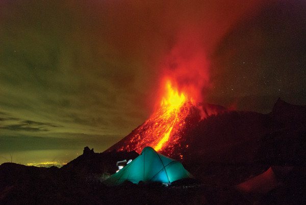
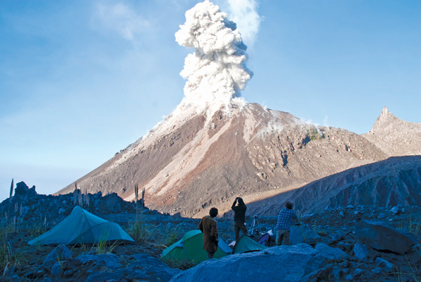
A large eruption as captured from the so-called "Paradise" campsite between the parent volcano, Santa María, and the Caliente dome. Credit: Benjamin R. Phillips.
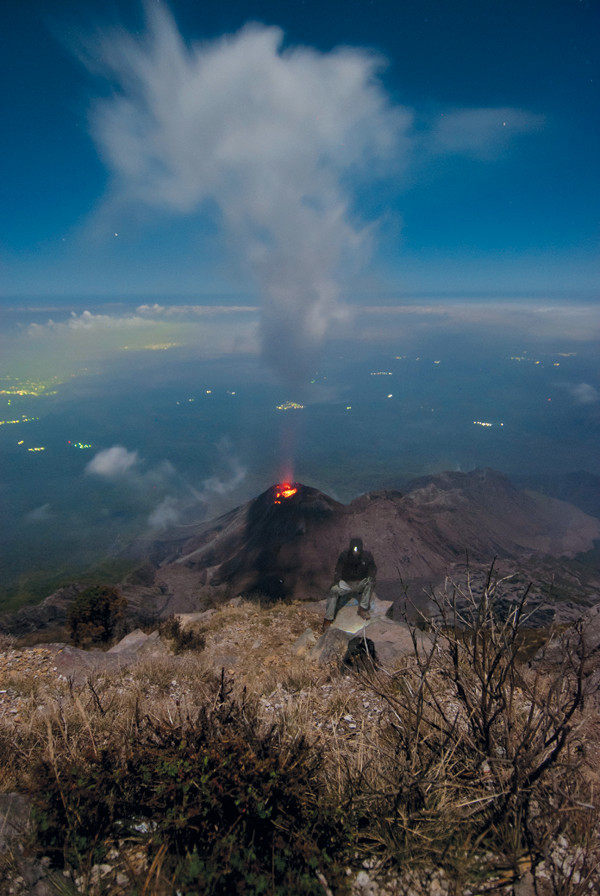
Self-portrait of the author on the edge of the nearly 2-kilometer-high scarp of Santa María. Credit: Benjamin R. Phillips.
If Earth breathes, Santiaguito Volcano in the Western Highlands of Guatemala could be its mouth. Roughly every half hour, like volcanic clockwork, Santiaguito’s active Caliente lava dome expands, filling with gas from depressurizing magma below. Then it exhales, often explosively, and deflates. Over the course of a day, you could almost keep time by it.
At Santiaguito, regular explosions take center stage, sending thundering clouds of ash and gas a kilometer high, which sometimes collapse and send searing-hot, billowing pyroclastic flows careening several kilometers down the mountainside. High-silica dacitic lava steadily oozes out of the Caliente vent, feeding flows up to a few kilometers long. The flows raft bus-sized blocks of solidified lava, which fall over the edge of the steep edifice before violently dancing down the volcano’s flank.
A key aspect of the Santiaguito stage is the equally grand amphitheater from which scientists can view these awesome acts of nature: Looming above immediately to the northeast is Santiaguito’s parent volcano, Santa María, its breached cone remaining from a 1902 eruption, and subsequent flank collapse that was 10 times the size of Mount St. Helens’ 1980 explosion. Santa María yields its own regular chorus of rockfalls, but is otherwise a safe spot from which to watch Caliente’s activity. A narrow, moonscape plain known as la playona, or the moat, runs between Santa María and the active vent. The moat is a world-class playground for geoscientists and adventurers alike. Tucked amid the remnants of one of the largest volcanic eruptions of the 20th century and the current locus of more than nine decades of subsequent activity, the moat offers views of the volcano akin to seeing a performance from the orchestra pit.
In 2012, a scientific team led by volcanologist Jeffrey Johnson of Boise State University, with funding from the National Science Foundation, set up a base camp in the moat to conduct two field studies of Santiaguito’s surprisingly regular rhythm, part of an ongoing interdisciplinary study. I was invited to participate in instrument deployment and data acquisition while documenting these expeditions. The initial results show promise that such integrated geophysical deployments could foretell episodic explosive eruptions, characteristic of a number of arc volcanoes worldwide.
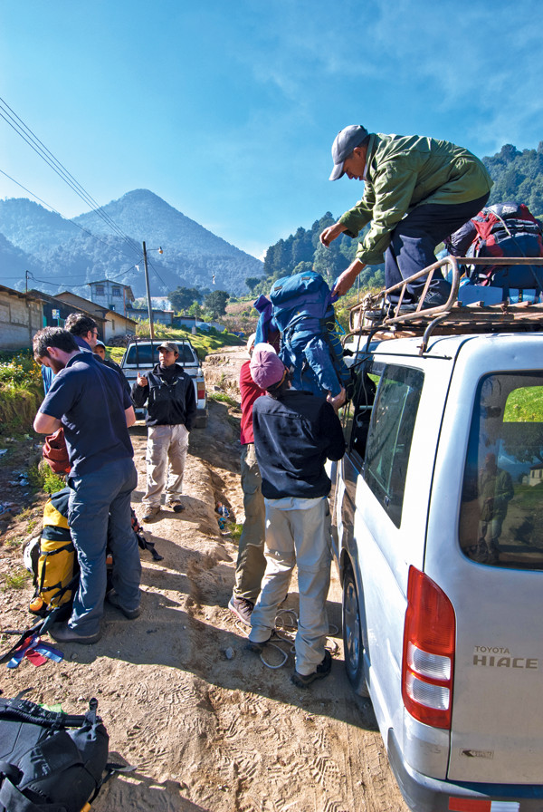
The science team unloads gear at the end of the road in preparation for the long trek to Paradise, with the undisturbed northern face of Santa María in the distance. Credit: Benjamin R. Phillips.
Our first day in the field, Nov. 11, 2012, was epic. Having arrived at home base in Quetzaltenango from Guatemala City the previous day, 10 scientists drove the remaining 10 kilometers to the base of Santa María. The full minibus, its roof mounded with lashed-down gear, and its shocks long since succumbed to the unmaintained mountain roads, lumbered carefully past the edge of the last village. We parked at the trailhead, and then started a steady eight-hour trek to base camp. At 2,500 meters elevation, a pack full of gear, batteries and instruments weighed heavy while legs and lungs struggled to warm up.
As we trudged along Santa María’s flank, we first caught a glimpse of Santiaguito and its two oldest domes — El Brujo and El Monje — from El Mirador, or “the viewpoint.” Then we began the descent around the northwest flank of Santa María. Crashing down a steep slope through thick brush, our thighs burned and our arms were scoured as we navigated our towering packs through meter-high tunnels of scrub. The air was thick with volcanic ash, knocked loose from platter-sized elephant-ear leaves as we plodded past. Johnson rightfully described this portion of the descent as a “tear-inducing, vegetation-choked, ash-infused hell on Earth.”
Less oppressive than the brush, but just as treacherous, was the smooth surface of the canaleta, a 10- to 20-meter-wide chute washed clean by floods on the flanks of Santa María. Fine, fresh ash covered the scoured lava channel, making it extremely slippery. Slowly and steadily, we made our way down. The canaleta empties into the primary drainage channel of Santiaguito, where we first took in the massive scale of volcanic earthworks carved by catastrophic lahars and prepared to climb upstream toward Caliente.
The main drainage channel reaches hundreds of meters in width, then constricts and steepens into a section dubbed the Khumbu Rockfall (after the similarly chaotic icefall on Mount Everest) — a jumble of unstable, refrigerator- to house-sized boulders and slick chutes pinched between the domes and the flank of Santa María. This was an exciting, but scary climb. The old domes, with unstable slopes, were in full view when not socked in by clouds. We donned our climbing helmets and made our way toward the younger La Mitad and Caliente domes.
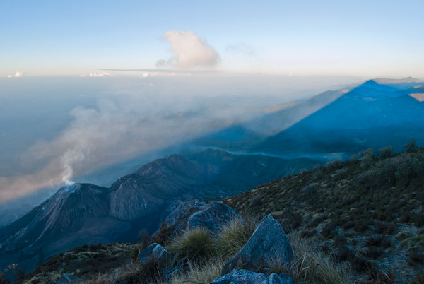
The cone of Santa María casts a sunrise shadow across Caliente and the three older domes. Along the eight-hour trek to the base of the volcano, one of the first glimpses of Santiaguito affords views of its two oldest domes: El Brujo and El Monje. Credit: Benjamin R. Phillips.
After emerging from the Khumbu Rockfall onto the primary plain of the moat, we were welcomed with our first clear view of the Caliente vent, and the sight and shuddering rumble of an eruption spewing a cloud of ash overhead. Less than 30 minutes later, during a late lunch, a second explosion unleashed a large pyroclastic flow. This was the first time many of us had seen pyroclastic flows. Fortunately, the flows and ballistics jettisoned by Caliente are concentrated primarily to the south and southeast, still within sight but directed away from our observing position.
Despite the relative sense of safety that the volcano’s regular activity instills, rockfalls are a constant hazard, and partial collapses of the unstable Caliente dome do, on occasion, create thick ash clouds that could have engulfed our position at any time, so caution was always needed. Not long after the second eruption, a magnitude-6.5 earthquake — an aftershock of the magnitude-7.4 thrust event off the Guatemala coast on Nov. 7, 2012 — let loose about 30 kilometers offshore and rumbled through our rest stop, sending a barrage of rocks cascading down the scarp of Santa María.
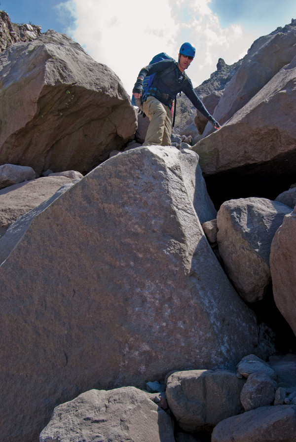
Seismologist Lee Liberty of Boise State University carefully descends the Khumbu Rockfall — a jumble of unstable, refrigerator- to house-sized boulders. Credit: Benjamin R. Phillips.
For many on the team, this was the most geophysically active hour we had ever experienced. But the aftershock was just a bonus. We were there for the volcano, and our front-row seat exemplifies the value of Santiaguito as an observatory for silicic dome eruptions. We could approach the base of the continuously active Caliente dome to install instruments and collect samples while colleagues simultaneously observed from a perch more than a kilometer above on the summit of Santa María.
Following our lunch break, our Guatemalan guide led us beyond the open plain toward base camp. Crossing two barrancas (several-meter-deep drainage gullies) we arrived at the site he had nicknamed “Paradise.” There was freshwater there in the form of a small waterfall, but aside from this luxury, the Paradise designation would be laughable to most mortals (or nonvolcanologists). Could this spot — on a rocky plain composed of past rock and debris flows tucked up against a kilometer-plus-high scarp so as to stay well out of the range of lava bombs from Santiaguito — even be called a campsite, much less paradise?
Nonetheless, for us volcanologists, the gushing column of incandescent rock streaming out of the vent was an awe-inspiring sight. This wild spot was indeed our own slice of heaven. As I climbed into my tent that night after a very long day, the peaceful gurgling of the waterfall was interrupted by the regular cacophony of rockfalls tumbling down Santa María, the half-hourly deep-throated roar of another eruption, and the ensuing rain of ash. Aching and exhausted, I lay in my sleeping bag — shutter release cable in hand — beside a tripod-mounted camera trained on the volcano in hopes of capturing the next big eruption that would shake me from my slumber. Santiaguito demands attention around the clock.
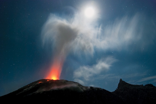
The incandescent Caliente vent lights the gas plume and provides a fiery counterpoint to the glow of the moon. Spines of the older La Mitad dome tower to the right. Credit: Benjamin R. Phillips.
An early-morning eruption viewed from the campsite. Credit: Benjamin R. Phillips.
Jeffrey Johnson of Boise State University prepares an infrasound microphone for deployment in the moat between the scarp of Santa María volcano and the Santiaguito domes. Credit: Benjamin R. Phillips.
The 1902 eruption of Santa María that carved this landscape was one of the world’s 10 largest historical eruptions, and the third largest of the 20th century after Novarupta in 1912 and Pinatubo in 1991. Santa María blew its top with a Volcanic Explosivity Index of 6 (the largest-known eruptions on this open-ended, logarithmic index have been designated as magnitude-8 events), dispersing an estimated 8.5 cubic kilometers of debris from western Guatemala to southern Mexico and causing worldwide atmospheric effects. Thousands of Guatemalans lost their lives due to direct effects of the eruption, with many more succumbing to disease and hardship in the aftermath.
One of the westernmost active volcanoes in the Central American Volcanic Arc, Santa María is a produ"t of subduction of the Cocos Plate beneath the Caribbean Plate. Activity there is estimated to have begun about 30,000 years ago, and has built the volcano into a prominent cone towering above surrounding population centers, from coffee plantations on its immediate flank to towns as close as about 5 kilometers downslope and all the way to the Pacific Coast 75 kilometers away.
Santa María is an archetype for stratovolcano study. As Johnson described it to me, the edifice was “dissected during the paroxysmal eruption of 1902,” leaving the interior of the composite cone exposed. The cross section reveals more than 30 lava flows, each up to 6 meters thick, with interbedded stacks of ash, pyroclastic flows and lahars. Although there is no historical record of activity at Santa María prior to 1902, Cakchiquel Indian legend does refer to grand eruptions of the volcano, which was known in ancient times as Gagxanul (the naked volcano).
Following a couple of decades of relative dormancy, new eruptions began in 1922 with the extrusion of a lava dome in the 1902 explosion crater on Santa María’s southwest flank. This dome-building phase has persisted now for nearly a century, with multiple three- to six-year-long episodes of high extrusion rates up to 2 cubic meters per second, interspersed with roughly decade-long periods of slower growth. In 1922, activity started at the Caliente vent, and then moved westward to La Mitad, El Monje and El Brujo to establish the four domes that now comprise the Santiaguito complex. Beginning in the late 1960s, extrusion returned to Caliente, where activity has been focused exclusively and continuously since 1986. Regular explosions have been common since at least the early 1970s. Averaged over time, Santiaguito has pumped out roughly enough magma to fill three Olympic-sized swimming pools every minute for more than 90 years.
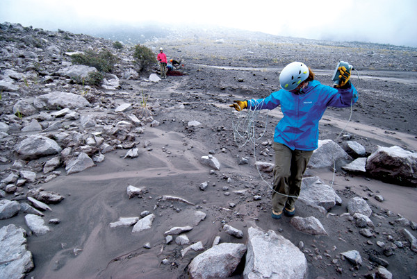
Kirsten Chojnicki, a graduate student from Arizona State University, now at the Scripps Institution of Oceanography, deploys an infrasound microphone in the moat. Credit: Benjamin R. Phillips.
Santiaguito’s annual to decadal reliability over the last century, and the ideal observational setting that it offers, are reasons enough to draw volcanologists to this rugged spot. Even more compelling is that recent efforts by Johnson and his colleagues have shown for the first time that the Caliente edifice inflates regularly on a much shorter timescale of only minutes.
Ten months prior to our November visit, in January, I had joined Johnson and other colleagues out here for a major instrument deployment on the volcano. On that occasion, we had deployed broadband seismometers, infrasound microphones and tiltmeters as close as we could to the Caliente vent, about 500 meters from the crater. “It is necessary to put these sensors as close as possible to the volcano in order to record subtle tilt signals that decay rapidly with distance,” Johnson said of the deployment.
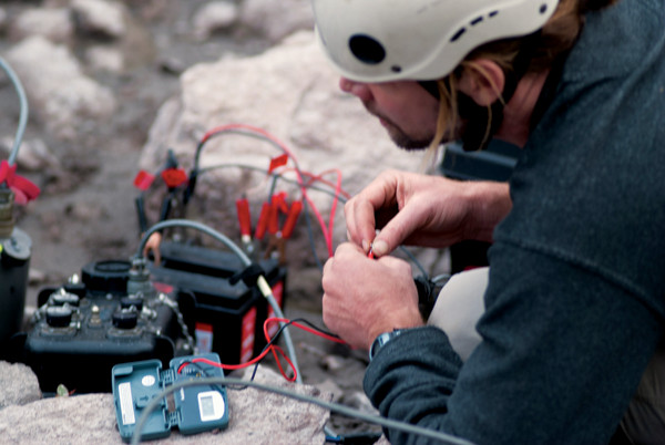
Johnson installs a seismo-acoustic- tilt station in the moat. Credit: Benjamin R. Phillips.
Team members dug 1-meter-deep holes in which to install the seismometers, which detected centimeter-scale shifts inside the volcano that revealed key changes in internal structure. The tiltmeters — with the sensitivity to measure changes in slope amounting to just 1 millimeter of elevation over a distance of 1 kilometer — were placed alongside and were key to measuring the subtle rise and fall of Santiaguito’s breathing as gases separated from magma.
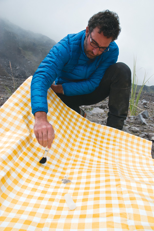
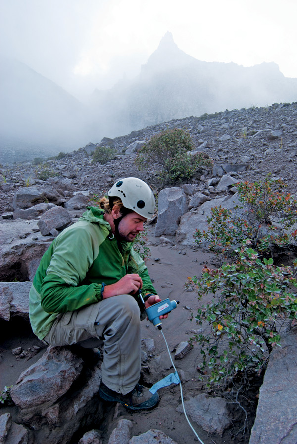
Corrado Cimarelli of Ludwig Maximilian University of Munich collects freshly fallen ash at Paradise. Credit: Benjamin R. Phillips.
Adding infrasound microphones on the surface, which can pick up the intense sound of explosive pressure waves that propagate at frequencies below the threshold of human hearing, aided the team in distinguishing exhalations that correlated with explosions from more mundane degassing events.
Now, we were back to check on the volcano and collect supporting data. The morning after our epic hike to Paradise, I got to work. In addition to chronicling the team’s work, I had duties that included installing a radio-triggered camera that was trained on the Caliente crater and synchronized with an array of other cameras high above on Santa María.
Ben Andrews, a geologist and curator at the Smithsonian National Museum of Natural History, led the photogrammetry effort from the summit of Santa María, deploying an array of five radio-triggered cameras along the edge of the scarp. The synchronized cameras allowed the researchers “to make a 3-D reconstruction of the dome surface through time. … We get a [digital elevation model] of the dome every 12 seconds,” Andrews said during the mission.
After setting up my camera, logging the GPS location, and checking in by radio with Andrews to coordinate with his array, I started acquiring images. These data, coupled with insights from the geophysical campaign, provide constraints on subsurface volcanic conduit geometry and processes, as well as lava effusion rates. Others in the group spent the day mapping, collecting samples and testing equipment in the moat.
All told, about a dozen investigators and as many graduate students came together on the volcano to carry out these carefully choreographed experiments. In the end, “we’ll be able to use the infrasound, or low-frequency acoustic data, to quantify explosions and track block-and-ash flows,” Johnson says of the complete field efforts. And together with the other tools, “we’ll also use the seismic data to better understand the earthquakes accompanying explosions,” and “how explosive volcanism occurs at silicic volcanic centers.”
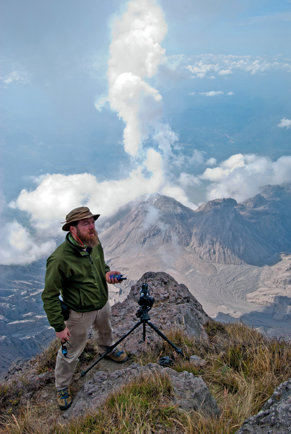
From above Santiaguito, Ben Andrews of the Smithsonian's National Museum of Natural History trains one of his photogrammetry array's cameras on the active dome. Five cameras dispersed several hundred meters apart across the jagged Santa María scarp recorded regular images for later 3-D time-lapse reconstructions of dome deformation. Credit: Benjamin R. Phillips.
In just two field seasons, Johnson and his colleagues have learned a lot about this volcano. They identified very-long period (VLP, characterized by displacement signals as long as 500 seconds) seismicity and collected tilt data that indicate roughly 26-minute (give or take about six minutes) inflation-deflation cycles. For a complex geologic system, this is about as close to clockwork as you can get, and is significantly more regular than Old Faithful’s eruptions (the time between events for the geyser ranges from 35 to 120 minutes). Almost one-quarter of these events are characterized by rapid tilting, punctuated by an explosion as recorded by an infrasound pulse and coincident VLP signal. The rest of the cycles show slower inflation rates, and culminate in only passive degassing without the associated acoustic signals. Time-lapse imagery clearly shows that heightened gas emissions do correlate with tilt cycles even in the absence of explosive events. Santiaguito has an undeniable half-hour respiratory rhythm, and the volcano does not miss a breath.
The data tell additional stories of an expanding gas reservoir hundreds of meters beneath the vent, and of gas rapidly streaming through the volcano’s conduit. The tilt measurements show that a bubble at this depth accumulates at least 10,000 kilograms of gas for each cycle. Most of this gas is water vapor, and the water vapor emerging from Santiaguito constitutes about 1 percent of the total flux of water estimated to come from the entire Central American Volcanic Arc. This type of scientific assessment is important for improving constraints on gas flux through volcanoes such as Santiaguito, given that volcanic-gas cycling has significant implications for the evolution of Earth’s mantle and atmosphere.
Episodic eruptive behavior is not unique — Colima Volcano in Mexico, Karymsky in Russia, Sakurajima in Japan, Stromboli in Italy, Semeru in Indonesia, and Montserrat in the Lesser Antilles are other examples. But Santiaguito’s regularity sets it apart, Johnson says. A final observation that may hold the secret to Santiaguito’s internal structure is that today’s consistent lava flows apparently aren’t phased by the inflation cycles. Instead, steadily rising magma appears to feed unhampered lava flows, while gas is trapped in an independently controlled subterranean reservoir, escaping only when it builds sufficient pressure to burst its way to the surface to drive Santiaguito’s unusual mode of respiration.
Santiaguito is a clear standout for studying the correlations between near-field volcanic deformation and explosive events. Other volcanoes may have similar traits, but the ability for geophysicists to approach the vent, deploy instruments close enough to detect these subtle shifts in internal fluids, and record this regular activity solidifies Santiaguito as a critical volcanic laboratory. If these mechanisms operate at other silicic volcanoes, application of the methods employed by Johnson and his team could hold broad promise for hazard mitigation.
So far, instruments have only been deployed while the scientists were in the field, collecting data for a week or two at a time before being recovered. Ultimately, permanent deployments could facilitate detection of changes in activity, perhaps foretelling more violent and hazardous eruptions.
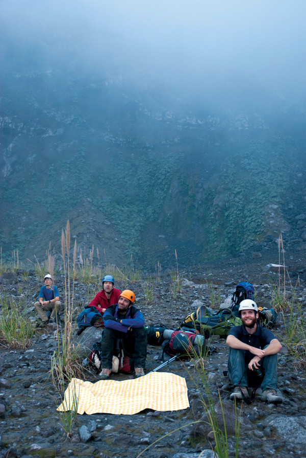
Team members take a break as they wait for ash at Paradise. Credit: Benjamin R. Phillips.
Despite the richness of these discoveries, they are only a few of the observational and analytical efforts underway by a larger group of scientists who worked together on the 2012 field campaigns. This transition from individual efforts to inclusive collaborations is being made possible by the new technologies and big data of modern geophysics. Volcanologists are part of the vanguard of this integrated mentality, and Santiaguito is a perfect proving ground.
A group from Ludwig Maximilian University of Munich (LMU) and the National Institute of Geophysics and Volcanology in Italy were also on the volcano to record multispectral video from the Santa María vantage point, tied together with other observations for future integrated studies extending to plume dynamics. As Corrado Cimarelli of LMU described, “high-speed and thermal video reveals sets of fractures opening in series at the margin of the dome, and jets of gas and ash streaming through and soon converting into convective eddies to form the plume.”
Cimarelli also collected ash as it sprinkled down from eruption plumes, urgently laying out collection tarps following explosions by the volcano. “Everything we can catch is fantastic, because nobody has ever looked into it,” he says. His interest lies in characterizing the extent of juvenile material being ejected to better understand conduit processes.
Ben Kennedy, of the University of Canterbury in England, and a graduate student — who described themselves as “old-school physical volcanologists, complete with hammers, compasses and maps” — mapped the older domes. The pair also collected samples to take home to their lab “to do high-temperature experimental volcanology on them … squashing them, heating them up, and pressurizing them to see how they behave at high temperatures and pressures,” Kennedy says. This work improves scientific understanding of the dynamic conditions that control magma transport through the conduit and into the crater.
That these teams operated on the volcano at the same time in a collaborative expedition is leading not only to deeper understanding and new discoveries, but to a unique educational environment that can serve as a model for the volcanological and greater geosciences communities. The ad-hoc collaborations that Johnson and colleagues have advanced will soon manifest in the first in a series of “Workshops on Volcanoes” at Santiaguito in January 2016. These workshops are envisioned as hands-on field experiences to not only educate the next generation of volcanologists, but to bring together leading scientists in an open-minded and open-data environment.
The inaugural workshop will bring a few dozen volcanophiles together on the volcano over a period of two weeks to share knowledge, techniques, expertise and data. This includes the organizers, roughly a dozen principal scientists, an equal number of graduate and post-graduate research assistants, competitively selected students up to the early-career scientist level, and host-country participants. But the field adventure will only be the beginning of the scientific exchange. Data, presentations from onsite tutorials, and analytical routines will be shared with participants and the broader community through venues such as Vhub.org (a virtual volcanic portal for collaborative research and risk mitigation) and the IRIS Data Management Center (the primary archive of the seismological research community operated by the Incorporated Research Institutions for Seismology).
Spending hard-won days and awe-inspiring nights keeping time with Santiaguito’s regular eruptions will surely make it an experience for all workshop participants to remember. And, if Johnson, Andrews and their colleagues have their way, the efforts at Santiaguito will spawn future workshops at other volcanoes and set a new trajectory for the volcanological community that will radically transform our understanding of how Earth breathes.
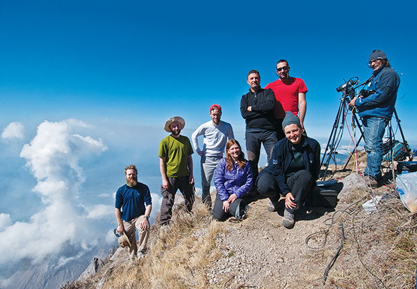
The high-speed video and photogrammetry teams — from left to right: Andrews, Andrew Nies (then at the University of North Carolina), the author, Chojnicki, Piergiorgio Scarlato (National Institute of Geophysics and Volcanology, or INGV, in Rome), Cimarelli, Elisabetta Del Bello (INGV Rome) and Daniele Andronico (INGV Catania) — on the summit of Santa María. Credit: Benjamin R. Phillips.
© 2008-2021. All rights reserved. Any copying, redistribution or retransmission of any of the contents of this service without the expressed written permission of the American Geosciences Institute is expressly prohibited. Click here for all copyright requests.