
by Mary Caperton Morton Monday, June 23, 2014
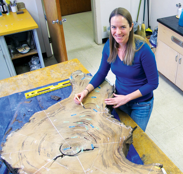
Ashley Streig and her colleagues examined tree stumps among other proxies. Tree-ring dating indicates this tree was cut prior to the earthquake of 1838 on the San Andreas Fault in the Santa Cruz Mountains. Credit: University of Oregon.
“This project took a lot of footwork,” says Ashley Streig, a paleoseismologist at the University of Oregon and lead author of the new study, published in the Bulletin of the Seismological Society of America. Using historical records, including written accounts of earthquake damage to Spanish-built missions in the area, Streig and colleagues identified and mapped the active fault trace through the Santa Cruz Mountains using both field reconnaissance and airborne Lidar.
Trenching across the fault uncovered evidence of past ground displacement by at least three earthquakes, including the 1906 event. “During an earthquake, the ground gets torn up. If you have new layers that come in and cap the disturbance, it will preserve a record of that event,” says Katherine Scharer, a paleoseismologist at the U.S. Geological Survey based in Pasadena, Calif., who was not involved in the new study.
Further evidence included hundreds of axe-cut wood chips under the earthquake layers, about 1.5 meters below the modern ground surface. “The wood chips gave us a post-European age constraint,” Streig says, meaning the quakes all occurred after the area had been settled by Europeans. “After this logging occurred, there were three earthquakes large enough to cause surface rupture, greater than a magnitude-6.”
Isotopic dating of the wood chips confirmed that the three earthquake horizons were likely created by events in 1838, 1890 and 1906. “These historical artifacts make the dating component of this study really very tidy,” Scharer says. “This work is exciting because they found a location with a really good stratigraphic record.”
The 1838 and 1890 events appear to have ruptured much shorter portions of the fault than the San Francisco earthquake, perhaps limited to the Santa Cruz Mountains, which run south of San Francisco for 62 kilometers between Los Gatos and San Juan Bautista. “This is the first time we’ve had good, clear geologic evidence of these historic 19th-century earthquakes,” Streig says. “It’s important because it tells us that we had three surface ruptures, really closely spaced in time that all had fairly large displacements of at least half a meter, and probably larger.”
Along the San Andreas Fault, the average recurrence interval between earthquakes is thought to be between 100 and 200 years, making the Santa Cruz section unusually active. But now, “it appears that there are more frequent surface-rupturing earthquakes on this section of the fault than have been previously identified,” Streig says.
What this means for the hazard profile for this section of the San Andreas is undetermined. “It’s difficult to say how much a short snapshot of time like this can tell us about longer trends on the fault,” Scharer says. Little long-term data is available for this section. “One of the challenges in studying the San Andreas around the Bay Area is that low, rounded mountains don’t tend to preserve long records,” Scharer says. On the southern sections of the San Andreas Fault, longer stratigraphic records are more common due to the mountainous terrain, she says.
Records going farther back in time are still needed, but in the meantime, the Santa Cruz data have been incorporated into the Uniform California Earthquake Rupture Forecast put out by the USGS. “Understanding the timing between earthquakes is one of the fundamental pieces of data that goes into generating the national seismic hazard map, which is used to establish engineering standards, allocate funds for mitigation and set earthquake insurance rates,” Scharer says. “These kinds of data are what we need to improve our ability to withstand these major events.”
© 2008-2021. All rights reserved. Any copying, redistribution or retransmission of any of the contents of this service without the expressed written permission of the American Geosciences Institute is expressly prohibited. Click here for all copyright requests.