
by Lauren Milideo Thursday, December 31, 2015
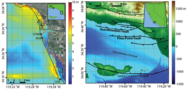
Map of the localized peak tsunami amplitude (below) due to a simulated earthquake on the Pitas Point and Lower Red Mountain fault systems (shown above), which extend east-west offshore of Santa Barbara (SB) and Ventura (V), Calif. The black and red lines indicate, respectively, the coastline and the extent of tsunami inundation based on maps put out by the California Emergency Management Agency. Inundation following the modeled earthquake exceeds the state prediction, particularly in the vicinity of Ventura Harbor (VH). Credit: both: Kenny Ryan, UC Riverside.
Earthquakes are well known along Southern California’s coast, and existing hazard maps indicate where quake-triggered tsunamis could flood the coastline. But in a new modeling study published in Geophysical Research Letters, researchers found that an earthquake-generated tsunami northwest of Los Angeles may reach farther inland than is currently projected.
Recent studies of Southern California’s Ventura Basin, which straddles the coastline around the city of Ventura, have suggested that faults there are able to generate larger earthquakes than previously thought, says co-author David Oglesby, a geophysicist at the University of California at Riverside. Those realizations have spurred geologists to question whether “the earthquake and tsunami hazard in this region may have been underestimated in the past,” and to try to assess the actual scope of the hazards, Oglesby says.
To address the questions, Oglesby and his colleagues created a computer model of the geometries and other physical properties of the Pitas Point and Lower Red Mountain faults, which lie mostly offshore. They then physically simulated an earthquake with a magnitude of roughly 7.7. The model yielded estimates of seafloor deformation, which when combined with fault location, seafloor bathymetry and coastal topography, offered information about the resulting tsunami’s scale, direction and extent of inland inundation, Oglesby says. Integrating these modeling techniques in this way to simulate an earthquake and resulting tsunami had not been done before, he adds.
The team found that, soon after forming, the modeled tsunami split into two separate waves. One traveled north toward Carpinteria and Santa Barbara, where damage would be limited by seaside cliffs and hills that would partially block tsunami inundation, note Oglesby and lead author Kenny Ryan, a graduate student at UC Riverside. The surprise, Oglesby says, was that the southbound wave was refracted 90 degrees to the east toward flatter and lower-lying Ventura and Oxnard, which produced wide-ranging inundation in those areas. “We find that in many places [the modeled tsunami] goes inland farther than the existing State of California tsunami inundation” maps predict, Oglesby says. Modeled inundations exceed those mapped by up to a kilometer, Ryan says, with much of this added inundation occurring around Ventura Harbor.
Oglesby notes that the modeled earthquake is “a severe but plausible event. That doesn’t mean that we think it’s going to happen next year, or even in the next hundred years necessarily.”
Although further work is needed to understand this fault system, the team’s “preliminary results show how important it is to study … tsunamigenic earthquakes, and the potential consequences should one of these large earthquakes occur on the Pitas Point-Ventura Thrust System,” says seismologist Thomas Rockwell of San Diego State University, who wasn’t involved in the research.
“This is one of the first studies to model potential tsunamis” in this system, Rockwell says. “We are still working out the details of the structural geology of this fold and thrust system, so this will not be the last model.”
Indeed, Oglesby says, further modeling is in the offing. Many of the assumptions about fault conditions and parameters that went into the models “are not terribly well-constrained,” he says.
This research also provides a template for studying other tsunami-prone locales, Oglesby says, noting that the “methodology could be applied to any number of places around the world to look at potential earthquakes and tsunamis from lots of different faults.”
© 2008-2021. All rights reserved. Any copying, redistribution or retransmission of any of the contents of this service without the expressed written permission of the American Geosciences Institute is expressly prohibited. Click here for all copyright requests.