
by Geoff Plumlee Thursday, January 5, 2012
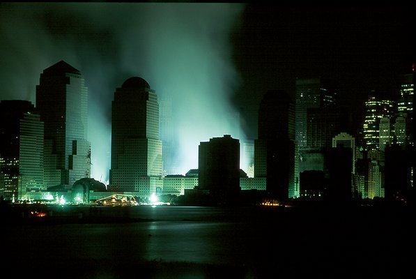
On Sept. 16, 2001, smoke still rose from the ground where the World Trade Center buildings once stood. Gregg Swayze, USGS
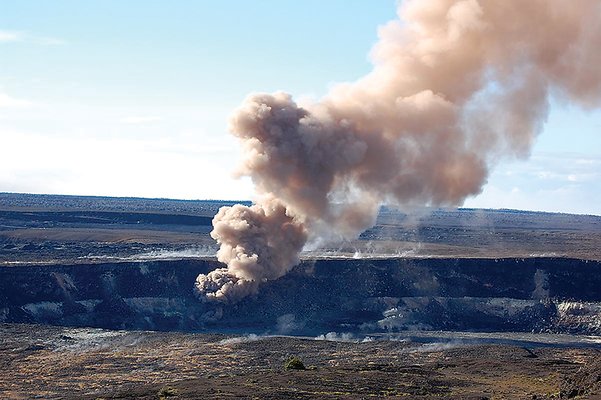
Halema'uma'u crater on Kilauea volcano in spring 2008. USGS researchers have assessed the characteristics of volcanic ash from this and other volcanoes. USGS Hawaiian Volcano Observatory
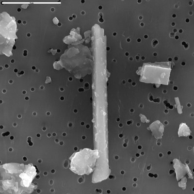
Scanning electron microscope image of an elongated crystal of silica found in Mount St. Helens ash in 2004. Heather Lowers, USGS
USGS researchers characterized the extensive dried mud deposits left behind by the flooding from hurricanes Katrina and Rita in 2005. Courtesy of John Lovelace, USGS
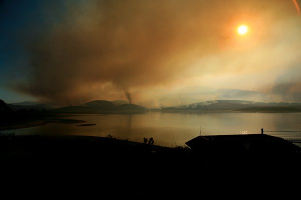
Smoke from wildfires blankets the San Diego area in October 2007. USGS researchers studied ash left behind by these fires and are beginning to analyze ash and smoke carried downwind from wildfires. Greg Mendez, USGS
Microscopic framboidal pyrite was found in mud samples from eastern New Orleans suburbs in the aftermath of the 2005 hurricanes. The pyrite was likely from marsh sediments. Greg Meeker, USGS
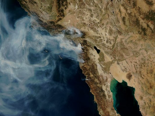
NASA satellite image shows the different wildfires burning on Oct. 24, 2007, and the extent of the downwind smoke plumes that enveloped much of the Southern California coast. NASA
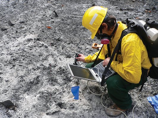
USGS geophysicist Ray Kokaly takes field reflectance spectroscopy measurements of ash and soil in Southern California burned areas. Todd Hoefen, USGS
People around the world remember when they first learned of the attacks on New York City’s World Trade Center towers on Sept. 11, 2001. For me, the memories are vivid — my feelings of shock, horror and sadness were similarly etched on the faces of all the attendees of a mining and the environment workshop in Buenos Aires, Argentina, where I was speaking. At that time, I had no idea that our small research group at the U.S. Geological Survey in Denver, Colo., would soon be called upon to help public officials understand the potential health and environmental implications of the disaster and the ensuing rescue, recovery and cleanup efforts.
Our focus was to help characterize the vast amount of dust and debris that settled out and covered much of lower Manhattan following the World Trade Center collapse. Our approach — applying many different earth science characterization methods to interpret how the dust and debris would respond to environmental processes— provided a unique and helpful perspective for emergency responders and residents living in the area.
Since 2001, our team has responded to a number of natural and anthropogenic environmental events, including examining the aftermath of hurricanes Katrina and Rita, which struck the Gulf Coast in 2005; the wildfires in Southern California in 2007 and 2009; volcanic eruptions at Mount St. Helens in 2004 and Alaska volcanoes in 2008 and 2009 (including Redoubt, which erupted last spring); and the ongoing East Java mud volcano eruption.
Each environmental response presents new challenges, but also yields new lessons. We have learned that earth scientists can play an important role in the aftermath of disasters, working in collaboration with emergency responders, public health specialists, cleanup managers and others who need to understand the materials resulting from disasters, how these materials behave in the environment, and the potential impacts they might have on the environment and human health.
Two days after the attack, officials at the U.S. Environmental Protection Agency and the Public Health Service Commissioned Corps (a division of the U.S. Surgeon General’s office) called USGS. They were aware of our group’s mineralogical characterization and remote sensing studies of asbestos in California and Montana, and asked us to help assess whether asbestos was a significant component of the dust and debris from the World Trade Center collapse.
USGS remote sensing expert Roger Clark spent several days working with our management and his colleagues at NASA to arrange the airplane carrying the Airborne Visible and Infra-Red Imaging Spectrometer (AVIRIS) remote sensing platform to fly over lower Manhattan and collect data on the settled dust and debris deposits.
While many people, including me, were still trying to get home following the temporary ban on air travel, team members Todd Hoefen and Gregg Swayze hastily organized their field gear and caught one of the first commercial flights from Denver to New York on Sept. 16. They spent the next two days collecting data on the ground that were used to calibrate the AVIRIS data. And they spent much of the next few nights walking around a largely deserted lower Manhattan, collecting sample after sample of the settled dust and debris for laboratory analysis that would help with interpreting the remote sensing data.
While Todd and Gregg were still collecting samples and field calibration data, Roger and his remote sensing colleagues were busy processing the reams of AVIRIS data arriving electronically. By Sept. 18, through a novel application of the AVIRIS data, they had developed and sent to emergency responders a thermal image showing the distribution of thermal hot spots where fires were still burning deep in the debris at Ground Zero. Firefighters used this image to help guide their efforts.
On Sept. 19, Todd and Gregg returned to Denver with the samples. Our team of analysts got busy, throwing all of our analytical capabilities at the dusts, driven by the hope that we would be able to help deal with the disaster that had shaken the nation.
Mineralogical analyses by Greg Meeker and others on our team quickly showed that although the dusts were quite heterogeneous, they were dominated by human-made glass fibers (slag wool), particles of gypsum (from wallboard), concrete and window glass shards. Many other materials were present in smaller amounts. Thankfully the samples did not test positive for any amphibole asbestos — generally viewed as the more dangerous asbestos variety — that our EPA contacts had feared would be in the dusts. Still, chrysotile asbestos, the less dangerous variety, was present in most samples at levels above those found in urban particulate matter, and in high levels in material coating some girders in the debris at Ground Zero. Lead, zinc, antimony, copper and other elements found in building materials were elevated in a number of dust and debris samples compared to natural soils; of these, primarily lead was present at levels of potential concern in some samples.
A field leach test, originally designed by USGS physical scientist Phil Hageman to rapidly assess the composition of storm runoff from mine waste piles, provided perhaps the biggest surprise. Instead of the acidic waters Phil was accustomed to measuring in most mine-waste leachates, the indoor dust samples produced highly alkaline, caustic leachates that were produced by dissolution of calcium hydroxide from the concrete particles. In contrast, outdoor dusts that had been rained on before Todd and Gregg collected them produced substantially lower pH values, because the dust had likely been neutralized by reactions with carbonic acid in the rainwater.
Roger, Gregg and others linked the AVIRIS data to the results of our lab analyses to produce a unique series of maps showing the distribution of asbestos, concrete and other materials in the dusts around lower Manhattan.
We completed preliminary analyses and released an initial report of our findings to emergency responders in New York on Sept. 27. Following additional work and peer review, we released a more detailed report to the general public on Nov. 27. We were gratified to see that both reports were heavily accessed via the Internet.
Since 2001, we have continued to improve our understanding of the World Trade Center dusts and report the results as we think of and apply new analytical approaches, such as evaluating additional characteristics of potential health concern. Over the years, we have heard from many sources that our work has provided important insights applicable to the initial disaster assessment and cleanup, and longer-term assessments of health impacts.
The World Trade Center response presented many challenges for which our prior training and work experience had provided little preparation. For example, we learned through the school of hard knocks how to conduct news interviews. Many interviewers wanted us to make sensationalistic statements about our findings that went well beyond what we felt was justified by the science or our particular expertise. We also learned important lessons in how to more clearly communicate our science to the public.
We were quite unprepared for the fact that our work would become entangled in the high-visibility legal battles and conspiracy theory fallout from 9-11. Since 2001, we have spent many hours documenting our activities and compiling all of our data, e-mails and other documents in response to Freedom of Information Act and subpoena requests made by World Trade Center litigants. Although being able to provide such documentation is a reasonable expectation (indeed, a duty) of us as scientists and public servants, the level of detail required by these legal calls has taken some getting used to.
On Aug. 29, 2005, Hurricane Katrina slammed into the Gulf Coast near New Orleans, La. Less than a month later, on Sept. 24, Hurricane Rita delivered a second punch. The storm surges, flooding, damage and loss of life turned into one of the largest, costliest natural disasters in U.S. history.
Our USGS colleagues in Louisiana played crucial roles during and after the hurricanes, monitoring floods and mobilizing to aid in search and rescue activities. As efforts shifted to damage assessment and cleanup, USGS began characterizing the coastal, ecological and environmental impacts of the storms. Our Denver group was asked to look at the environmental, health and cleanup implications of the extensive flood sediment deposits left behind in the New Orleans area after the hurricane floodwaters receded.
Based on what we had learned from the World Trade Center, we designed a more comprehensive, interdisciplinary response involving more collaborators and more rigorous sampling. Our primary goal was to characterize the flood deposits for a broader range of parameters, adding organic chemicals, pathogens and other characteristics of potential environmental and health concern to the list.
USGS Louisiana Water Science Center Director Charlie Demas served as the liaison with the emergency responders and cleanup managers on scene in the days and months following the storms. Due to logistical considerations that precluded us from getting to New Orleans, Charlie arranged for John Lovelace and others on his staff to collect the samples. Given their proximity, they could collect samples at various times after both hurricanes.
We found that the composition and makeup of the flood sediments varied systematically around New Orleans. These differences reflected varying sources of the sediments and posed different environmental and health concerns.
For example, marsh-derived flood sediments in New Orleans’ eastern suburbs such as Chalmette contained low levels of heavy metals, but high levels of framboidal pyrite. If left unaddressed, weathering of the pyrite would likely cause the muds to develop acidic runoff that could adversely affect surface-water quality and aquatic organisms. In northern New Orleans near Lake Pontchartrain, the lake-derived flood sediments had minor levels of pyrite and generally low levels of heavy metals; only in one or two hot spots in this area did we find levels of various heavy metals that were of potential health concern.
Downtown New Orleans, however, was another story. Due to its higher ground, it experienced less flooding, but it was where we found the most troubling results. There were abundant human-made materials such as brick fragments and other construction materials, as well as extremely high levels of lead, arsenic, cadmium and organic contaminants such as polycyclic aromatic hydrocarbons (PAHs) — chemical compounds found in coal, tar and oil, and produced by combustion of organic matter. Spatial patterns of heavy metal and PAH enrichment in the downtown flood sediments mirrored those measured by Howard Mielke, a professor at the Tulane/Xavier Center for Bioenvironmental Research, in pre-Katrina soil studies of New Orleans. Hence it was clear that the downtown flood sediments were mostly reworked, highly contaminated, locally derived urban soils. Mielke’s work showed that understanding pre-disaster environmental baseline conditions is crucial to interpreting the extent of disaster effects.
Suzette Morman, a USGS specialist in geology and public health, ran leach tests using simulated gastric fluids on the downtown flood sediments, and found that the lead and heavy metals were likely to be highly bioaccessible should the sediments and soils be incidentally ingested. Mielke has argued for years that the contaminated soils in downtown New Orleans pose a substantial health threat, and have resulted in widespread elevated blood lead levels in young children living in the area.
USGS microbiologist Dale Griffin analyzed DNA extracted from the mud samples to screen for the presence of various pathogens. Surprisingly, he found a relatively high number of hits (five out of 19) for the natural form of the soil bacteria Bacillus anthracis, which causes the disease anthrax. The latency period for development of anthrax following the hurricane and cleanup had already passed by the time Dale’s initial results came in, with no cases of the disease having developed in people exposed to the muck.
Regardless, Dale notified the Centers for Disease Control and Prevention of his findings, and spent considerable time over the following months carefully verifying and interpreting the results. In contrast to the Katrina flood sediments, he had used the same test on soil samples collected along a north-south transect across the United States, and detected B. anthracis in only five of 104 samples. To help put this in a regional context, Dale collected more soil samples on a transect along the Gulf Coast and resampled the same locations from which the Katrina flood sediments had tested positive for B. anthracis. None of these samples produced any hits, suggesting that the bacteria were storm-related phenomena.
He concluded that flooding conditions enhanced the growth of the bacteria, although apparently not to levels high enough to cause anthrax in humans and animals exposed to the floodwaters and muds. Over time, after the floodwaters receded and the muds dried out, the bacteria apparently went back into hiding in the soils in their less readily detectable spore form.
Although helpful, our findings may have also had some unexpected consequences. Mielke told us that our results (and those from his, EPA and other studies) were used by cleanup authorities to determine that hurricane cleanup funds should not be used to restore the contaminated soils because the elevated heavy metals in the downtown area were present before Katrina and Rita struck. Soil contamination therefore remains an issue in parts of urban New Orleans.
Devastating wildfires hit widespread areas of California with dismaying frequency, many in areas at the wildland-urban interface where there are potentially significant impacts on property and lives. In conjunction with the USGS Southern California Multi-Hazards Demonstration Project, we are working with USGS wildfire ash specialist Deb Martin to understand the potential environmental and health hazards posed by the materials produced by wildfires.
In 2007 and 2009, we collected samples — this time of wildfire ash and burned soil in both wildland and residential areas. With the help of USGS biologists and hydrologists, we focused on sampling locations where the fires and ash deposits could have a significant impact on endangered species, water quality and health.
Analyzed residential ash samples showed elevated levels of copper, zinc, arsenic, cadmium, chromium, lead, chlordane (a legacy pesticide no longer used in construction) and other chemicals or materials that would result from the burning of building materials. Tests by USGS chemist Ruth Wolf indicate that some of the chromium is in the readily soluble, more toxic hexavalent form. We are still trying to determine how much of this results from the combustion of various building materials. It is also unclear whether the levels of hexavalent chromium in the residential ash pose any health risk to humans or animals that inhale or are otherwise exposed to the ash.
Wildland ash samples, meanwhile, tend to have substantially lower levels of most potentially toxic heavy metals. Further work is pending to examine the role that vegetation, bedrock geology and burn intensity play in ash composition and environmental effects.
Phil Hageman’s water leach tests indicate that white ash (the most completely combusted ash) and ash from burned residences (which presumably combusted at generally hotter temperatures than wildland vegetation) produce highly alkaline, caustic leachates. In contrast, samples from wildland areas with intermixed white ash and black ash (less heavily combusted ash) produce somewhat less alkaline leachates. Therefore, the first rainfall to hit a burned area would, depending upon the burn intensity, be expected to produce alkaline to very alkaline runoff that could be detrimental to aquatic organisms. As with the World Trade Center dusts, carbonic acid in the rainfall would eventually neutralize the caustic alkalinity in the ash.
Suzette Morman’s simulated lung fluid leaches of the ash produced similar, though not as extreme, shifts in pH as the water leaches. These results are in agreement with what was already known about fire ash — that, due to its caustic nature, it can produce irritation or corrosive tissue injuries when it comes into contact with wet skin or is inhaled. Local, state and federal agencies routinely caution people to wear appropriate skin and respiratory protection when re-entering burned areas or buildings, but media photos following most wildfires suggest that many people do not heed these warnings.
The list of environmental disasters that we have responded to goes on, but with each new response we face familiar challenges and invariably encounter new ones. And with each experience, we continue to learn from our mistakes and improve our subsequent efforts. We continue to improve how our interdisciplinary approach, which focuses on environmental processes and baselines, can contribute to broader disaster response and planning efforts.
Communication has perhaps been the biggest challenge for us, both in timing and in message. The key goal of any response effort is to get information on results and interpretations to emergency responders, recovery managers and the public in as timely and understandable a manner as possible. That means getting the news out there fast, but also in a meaningful context that neither under- nor overstates potential hazards.
Conducting media interviews has also been difficult. As scientists, we are accustomed to thinking in shades of gray, not the black or white seemingly desired by the media. We don’t make statements outside our area of expertise, such as the public health implications of our results; instead, we work with public health agencies so that they can provide the timely and appropriate public health context.
Involvement in disaster response poses the logistical and intellectual challenges that make the work even more fulfilling. But the response doesn’t end with the last collected sample. The aftermath of a disaster requires us to describe clearly and comprehensively what we did, why we did it, and our best assessment of the limitations of our approach. This helps thicken our skin to deal with misrepresentation of our work by those who have agendas not supported by the science. We need to document, document, document and save, save, save everything from day one of the response, and be prepared to produce this documentation in the likelihood it will be subpoenaed or requested under the Freedom of Information Act as part of post-disaster litigation.
Finally, one of the biggest emotional and sobering challenges for our group has been coping with the realization that we are dealing with the aftermath of events that have adversely affected people’s lives, or that have led to the substantial loss of human life. We cope with this by pouring our hearts and souls into our disaster response efforts — and hopefully we help communities recover from past disasters and prepare for future disasters.
© 2008-2021. All rights reserved. Any copying, redistribution or retransmission of any of the contents of this service without the expressed written permission of the American Geosciences Institute is expressly prohibited. Click here for all copyright requests.