
by Terri Cook Monday, February 11, 2013
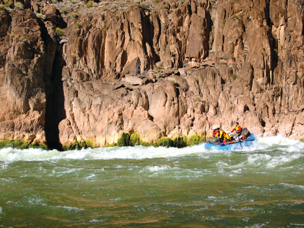
The Colorado's water is in high demand for drinking and irrigation, as well as recreation. More than 20,000 rafters run the river each year. Mary Caperton Morton
As the Colorado River winds through the Colorado Plateau’s layer cake of soft sedimentary strata, it picks up a tremendous amount of sediment, which once left the river’s warm waters so muddy that Spanish explorers christened it El Rio Colorado, “the reddish river.” Today, that sediment is deposited in the reservoir behind the Glen Canyon Dam, leaving the discharge water — drawn from deep in the lake — clear and cold.
Although now a dazzling blue-green instead of muddy red, the cold, crystalline waters signal major environmental changes — with serious implications for the health of the river’s ecosystems. One of these is the substantial and ongoing erosion of the Grand Canyon’s beaches and sandbars, as well as a drastic reduction in the water’s turbidity, both of which may play a role in reducing the survival rate of endangered native fish.
Completed in 1963, Arizona’s Glen Canyon Dam is an enormous, 216-meter-tall concrete wedge that impounds Lake Powell, the second-largest reservoir in the U.S., with a capacity of 33 cubic kilometers. This dam, and its slightly larger downstream neighbor, Hoover Dam, have played a significant role in opening up the southwestern United States to settlement. Nearly 40 million people now depend on irrigation and drinking water from the Colorado River, and millions rely on electricity and flood control from these and dozens of other dams scattered throughout the river’s drainage. Yet despite these many benefits, due to Glen Canyon Dam’s massive size and its location just 24 kilometers upriver from Grand Canyon National Park, in the half century since its construction, Glen Canyon Dam has become one of the Southwest’s biggest environmental controversies.
Researchers studying how the dam is changing the Grand Canyon’s geomorphology and biology have monitored the results of seven intentional floods, with the four largest occurring in 1996, 2004, 2008 and 2012. The goal of these “high-flow experiments” has been to determine whether controlled flooding could benefit native fish, sandbars and cultural sites that have been drastically altered by the dam’s construction and 50 years of operation.
Scientists have discovered a lot from these experiments, but one of the biggest lessons they’ve learned is that they still don’t know enough about the interactions of sediment, water and fish in the Grand Canyon. They hope to rectify that situation with a new research and experimental protocol — a plan to implement more frequent water releases when enough sand has accumulated — that Secretary of the Interior Ken Salazar called “a milestone in the history of the Colorado River” when he introduced it last May. Whether these new management strategies can help reverse the damage done to the Grand Canyon’s natural systems over the last 50 years remains to be seen.
Sandbars are a critical component of the Grand Canyon ecosystem, providing essential habitat, like warm backwaters, for species in the river’s intricate food web. The creation and maintenance of sandbars, however, depend on how much sediment is coming into the system and how fast the water carrying that sediment is flowing.
Prior to construction of Glen Canyon Dam, the Colorado River transported some 60 million tons of sand each year, and flows varied by as much as 600 percent from one year to the next. Each spring, an inundation of meltwater often left new sandbars and beaches in its wake.
Today, the dam has cut off 94 percent of the river’s sand supply and tamed its wildly fluctuating flows, eliminating large spring floods altogether. However, in order to provide water and electricity, the average daily flow is now often higher than before the dam was constructed.
Now, most of the sediment available to replenish the sandbars and beaches is deposited, mainly during floods, by the two largest tributaries that enter below the dam: the Paria River, which enters the Colorado River at Lees Ferry, and the Little Colorado River, which meets the main stem another 95 kilometers downstream. However, the clear water discharged from the dam now quickly carries off much of that sand.
Scientists have seen habitat changes reverberating through the Grand Canyon’s food chain. Organic matter from throughout the river’s basin once sustained a diverse group of aquatic insects and formed the base of a complex food web. Today the organic material, like the fine sediment, settles to the bottom of Lake Powell upstream of the dam, and the clear waters flowing out of the dam instead support Cladophora, a filamentous algae that native fish like the humpback chub won’t eat. Of the eight native species of fish in the Grand Canyon, two — the humpback chub and the razorback sucker — are federally listed endangered species, and another three have disappeared from the stretch of river below Glen Canyon Dam. Since the 1990s, the razorback sucker had been widely believed to be extinct in the Grand Canyon until a biologist from the Arizona Game and Fish Department caught one last October.
However, it’s not just the lack of sediment and changing food sources that have adversely affected many native fish. Water temperature — also affected by Glen Canyon Dam — is a critical factor as well. Prior to the dam’s construction, the Colorado’s water temperature varied widely, from 29 degrees Celsius in summer to freezing in winter. Now, with the exception of several recent years when lake levels dropped, thus warming bottom waters, the water averages 8 to 10 degrees Celsius year-round.
Since Lake Powell completed filling in 1980, non-native coldwater fish, including rainbow, cutthroat and brown trout, have been thriving in the river. In fact, the stretch from Lees Ferry to the dam has become a world-class trout fishery. But these introduced fish often move downstream into the Grand Canyon and prey on young native fish. That predation, plus habitat loss and intense competition for limited food, are generally thought to have radically reduced the number of native fish.
Both the National Park Service and the Grand Canyon Protection Act of 1992 mandate that natural resources within the Grand Canyon, including native fish and sand, be protected. In order to do that, however, scientists and decision-makers first needed to better understand the post-dam ecosystem. Thus, in recent decades, researchers — including those from the U.S. Geological Survey (USGS), U.S. Fish and Wildlife Service, U.S. Bureau of Reclamation, National Park Service, Arizona Game and Fish Department, and many other federal and state agencies, universities and Native American tribes — have been studying how the dam affected the river.
In light of the ecological changes already wrought by the dam, a few groups, including the Sierra Club and the Glen Canyon Institute, have called for the dam to be decommissioned and Lake Powell drained, but Congress has repeatedly instructed the Bureau of Reclamation, which operates the dam, not to consider this option.
Since 1996, the Bureau of Reclamation has operated the dam under an “adaptive management” program, which, in essence, means “learning by doing.” The goal of the program is to use feedback from long-term research and monitoring to modify dam operations to improve the condition of downstream resources while continuing to provide water and electricity.
Research efforts have focused on the idea of using Glen Canyon Dam to generate controlled floods based on geologists’ understanding of the natural cycle on the pre-dam Colorado. Scientists hoped that a moderate, dam-generated flood would scoop sediment, which had accumulated for years on the riverbed, out of the channel and redeposit it above the shoreline — restoring beaches and backwater nursery habitats, irrigating native vegetation and flushing out non-native fish.
The timing of the first controlled flood, conducted in spring 1996, was based on the levels of water storage in the Upper Colorado. Scientists waited anxiously as the Bureau of Reclamation cranked open the valves for seven days to let a steady flow of 1,270 cubic meters per second downstream. It was the largest volume of water to surge through the canyon since 1983 when the lake nearly overtopped the dam, prompting a release of 2,750 cubic meters per second.
After the 1996 flood, USGS researchers found that, although sand was rapidly deposited during the first few days as expected, it was subsequently eroded by peak flows later in the flood. In addition, the artificial flood was not large enough to flush out the non-native fish or to remove invasive vegetation from the remaining sandbars and beaches.
The experiment overturned the idea that, under normal dam operating conditions, sand carried to the Colorado by the tributaries, especially when they flood, would accumulate in the channel over a period of years. What it revealed instead was the river was so sediment-starved that, in most years, tributary sand is carted away within just a few weeks or months, even when annual releases are below average.
The results convinced managers that the timing of future controlled floods should depend not on how much water was stored upstream, but on how much sand was available downstream, a concept called “sand triggering.” In 2004, the Bureau of Reclamation waited until USGS scientists confirmed that a sufficient amount of sand had accumulated in the main stem from the tributaries, then quickly conducted a controlled flood to rebuild the sandbars before the river could carry the sand downstream. To avoid flushing sand from the system, the water was released for about a third of the time it was in 1996. Following large sand inputs from tributary floods in 2006 and 2007, another flood was unleashed in spring 2008. By then, however, much of the finest sand had already been transported downstream.
The 2004 and 2008 controlled floods revealed other important lessons about the fate of the accumulated sand. In 2004, increases in sandbar area and volume occurred closer to Glen Canyon Dam, where the Paria contributes substantial amounts of sediment. But farther downstream, where sand was less abundant, a net loss still occurred. Researchers concluded that more sand was needed to rebuild sandbars throughout the 445-kilometer stretch of Grand Canyon National Park.
In 2008, sand supplies from tributary floods were three times greater than in 2004. Sandbars measured during the 2008 flood were still growing at the end of the high flows and bars were rebuilt nearly throughout the river down to Lake Mead. Scientists thus concluded that controlled floods conducted shortly after tributaries dump sand in the main channel are the only effective means of rebuilding sandbars.
But they also discovered that sandbars tend to erode quickly in the weeks and months following controlled floods unless dam discharge is less than 255 cubic meters per second, which is commonly less than the flow rate maintained under normal dam operating conditions to provide electricity.
Another surprise was that the grain size of the sand is also important. However, “it’s the old adage of the double-edged sword,” says Ted Melis, deputy chief of the USGS Grand Canyon Monitoring and Research Center in Flagstaff, Ariz. The sandbars need the finest sand available “because it’s the easiest to mobilize and, presumably, to deposit most quickly,” he says. “At the same time … that finest sand is also the easiest to erode once the flood is over.”
Ultimately, the controlled floods showed that when there is significant sand enrichment in the river, especially if the sand is fine-grained, an opportunity exists to rebuild sandbars. Yet according to Melis, sediment scientists still haven’t confirmed or refuted the fundamental conclusion first reported in 1976 by Emmett Laursen, then an engineering professor at the University of Arizona. Laursen and colleagues concluded that, without remedial measures, the beaches between Glen Canyon Dam and Lake Mead would be washed away within 100 to 1,000 years.
The key question still to be answered is: Can artificial floods rebuild eroded sandbars faster than dam operations erode them? The answer depends on how the dam is operated and how frequently the opportunities to rebuild sandbars arise, Melis says, as well as on climate change, which could affect both water supplies in the upper Colorado River Basin and sand supplies from downstream tributaries.
The other key question investigated during the high-flow experiments was how the floods affected the fish. The response of fish to controlled floods is difficult to decipher because floods simultaneously alter many variables, leaving scientists to work out which are the most important.
After 2008, researchers concluded that none of the flow experiments over the last 20 years, including steady and low-flow trials, had any measurable effects — positive or negative — on humpback chub and other native fish populations. However, the same is not true for the introduced rainbow trout living in the shadow of the dam, and scientists are still trying to figure out why. One likely reason is that, unlike the trout, the chub spawn in the Little Colorado River, rather than the main channel.
Following a steady decline in the population of humpback chub in the Grand Canyon from 1989 to 2001, the species bounced back between 2001 and 2008, with the population increasing by 50 percent. This trend seemed to persist regardless of whether or not there was a controlled flood.
The trout population, however, followed nearly the opposite trend, increasing from 1991 to 1997 following the implementation of a steadier flow regime, then declining from 2000 to 2007. Scientists also observed rainbow trout population increases in 1997, the year following the first controlled flood.
Scientists had anticipated that the controlled floods would displace both native and non-native fish and that some rainbow trout eggs and juveniles would die. Unfortunately for the chub, however, rainbow trout populations in Glen Canyon, Marble Canyon and the Grand Canyon increased dramatically for two years following the spring 2008 flood, most likely due to an increased survival rate of young trout (and a decrease in adults to prey on or compete for food with them). The 2008 cohort of rainbow trout spawned near Lees Ferry was the second largest on record. And some of these fish apparently moved downstream near the Little Colorado River, where an eight-fold increase was observed in 2009 compared to two years earlier.
Such observations led researchers to conclude that spring floods actually benefit rainbow trout populations for up to two years by “cleaning” their spawning and rearing habitats and by stimulating the food supply by increasing aquatic invertebrate populations, such as midges and black flies. The increased food availability documented in spring 2008 occurred when young trout were emerging, thus they were able to grow quickly and survive better in nearshore habitats where they can avoid predation.
Ongoing studies tracking the large trout population could still ultimately show that the 2008 experimental flood had a negative effect on adult humpback chub populations downstream in Grand Canyon National Park. (Results are not immediately apparent after the floods, because many effects occur in juvenile fish and scientists have generally examined adult population trends. In 2008 though, scientists began monitoring juvenile populations as well.)
Although the mechanisms underlying the chub’s recent population increase remain uncertain, evidence is mounting that warming water temperatures — due to drought-reduced lake levels — and the smaller number of rainbow and brown trout compared to previous years when dam releases were consistently colder, both play important roles. Humpback chub are warmwater fish that require temperatures of at least 16 degrees Celsius to initiate spawning. At temperatures of 10 degrees Celsius or below, juvenile growth rates are nearly zero. Additionally, researchers have shown that the ability of juvenile chub to swim and avoid predators falls off dramatically as water temperatures decline. When rainbow trout populations have been large, humpback chub populations have generally declined, probably due to both increased competition for food and habitats and predation.
“We are still not sure why trout began to decline systemwide after about 2000, but it definitely occurred in advance of the onset of warmer dam releases and prior to the upswing in chub population numbers,” Melis says. “It is impossible to say which, if either, of these two factors has played the bigger role in the upswing.” It could also be due, at least in part, he says, to the experimental lethal removal of about 23,000 non-native fish from the main stem in the Little Colorado River between 2003 and 2006.
The strong response by rainbow trout to the spring 2008 controlled flood was not predicted by researchers, though a similar counterintuitive response occurred with a flow stabilization (a decrease in the daily range in dam discharge) experiment in the 1990s.
These lingering uncertainties indicate that researchers may not have identified all the key variables controlling native and non-native fish populations, according to a 2011 USGS circular report by Melis and others. In particular, the study suggests that the importance of flow regimes to humpback chub may have been overestimated, whereas other factors, such as the influence of water temperature, may have been underestimated.
Based upon the results of the controlled flood experiments of the 1990s and 2000s, the Adaptive Management Working Group began to rethink the strategy for rebuilding and maintaining sandbars and last year reached a consensus on the conditions under which the next controlled floods should be initiated.
In May 2012, Salazar announced a new 10-year “High Flow Experimental Protocol,” which is based on a “sand accumulate-and-release” strategy. During years of below-average dam releases, managers will allow sand from tributaries to accumulate during a several-months-long window, then unleash a controlled flood immediately after the window closes. If that’s not possible for legal reasons — such as the need to meet water delivery or storage obligations — they may alternatively reduce flows until a high-flow experiment can occur, to prevent the deposited sand from being washed away.
“This new protocol allows experimental high flows to occur more frequently than previous experiments on the basis of sand production from the tributaries below the dam, mainly, the Paria River,” Melis says.
To be cautious about the possibility that enhanced rainbow trout production might still be a threat to chub downstream, the Department of the Interior has limited these experiments to autumn until at least 2015. Species are at different life-cycle stages during different seasons. “The hope on the part of many managers is that fall-timed high-flow experiments will not have the same biotic responses as the ones released in the spring,” Melis says, “but this is a big uncertainty, one that we will hopefully be able to resolve sooner rather than later through our monitoring.”
The new protocol was put to the test for the first time last fall. After sufficient sand accumulated in the channel, managers released a fourth large controlled flood on the Colorado River in mid-November.
Initial results were not yet available as EARTH went to press. However, if the rainbow trout and food web responses following the 2012 flood are similar to what occurred in previous floods, then the concerns about the production and downstream migration of trout will need to be considered more carefully relative to sandbar conservation objectives, Melis says.
“Balancing objectives in co-managing a [non-native] recreational fishery upstream with an endangered native fishery downstream is likely one of the biggest challenges now faced by … the adaptive management program,” he says, especially when the research continues to provide unexpected results. But while “scientists tend to find surprise findings quite satisfying and often find inspiration to ask new questions as a result, [resource] managers don’t always appreciate these unexpected learning opportunities.”
Going forward, managers and scientists plan to continue to implement fall floods if enough sand is carried by the tributaries into the main stem each monsoon season, and to monitor those floods to better understand how the new flow regime of the Colorado affects fish populations. “Regardless of how many sandbars were gained or lost in the recent experiment, we know that the question about whether or not there is enough sand below the dam to rebuild and maintain sandbars can’t be answered in a single flood,” Melis says, “but only after a longer period of consistently repeated tests followed by careful monitoring and analyses.”
© 2008-2021. All rights reserved. Any copying, redistribution or retransmission of any of the contents of this service without the expressed written permission of the American Geosciences Institute is expressly prohibited. Click here for all copyright requests.