
by Timothy Oleson Thursday, June 16, 2016
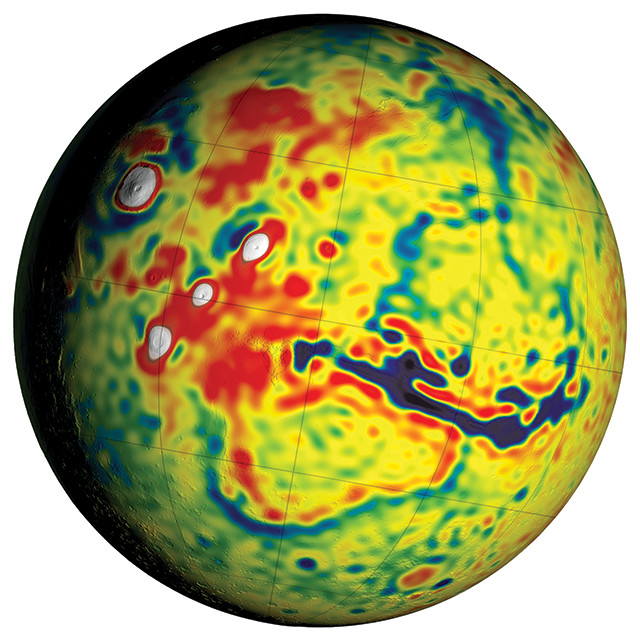
On the new gravity map of Mars — with warmer colors indicating higher gravity — white spots represent Mars' largest volcanoes, including Olympus Mons to the upper left, and the dark blue streak represents the gaping Valles Marineris canyon system. Credit: NASA/GSFC/Scientific Visualization Studio.
With two rovers patrolling the surface of Mars, five spacecraft orbiting above it, and scientists here on Earth studying the Red Planet from afar, new findings are announced often. Here are a few of the latest updates.
Scientists have produced the most detailed gravity map of Mars yet, combining sensitive measurements from three orbiting missions to gain new insights into the planet’s internal and external character. Small variations in Martian gravity due to the uneven distribution of the planet’s mass cause the paths of orbiting satellites to change slightly. Researchers assembled the map after analyzing 16 years of data capturing the slight gravity-induced course shifts of the now-retired Mars Global Surveyor and the active Mars Odyssey and Mars Reconnaissance Orbiter (MRO) missions. They detailed observations from the effort in a new study in the journal Icarus.
“The better resolution of the new map helps [scientists] interpret how the crust of the planet changed over Mars’ history in many regions,” said lead author Antonio Genova of MIT and NASA’s Goddard Space Flight Center, in a statement. For example, a low-gravity anomaly between the Tempe Terra and Acidalia Planitia regions thought to represent a system of buried channels may have resulted in part from flexure of the lithosphere there as a result of the formation of the massive Tharsis volcanic region to the west, they suggested. The team also found evidence of tidal motions in Mars’ crust and mantle, which confirms earlier hints that the planet has a liquid outer core.
Mount Sharp — a 5-kilometer-tall peak built from sedimentary strata in the middle of Gale Crater — has been the main subject of the Curiosity rover’s investigations since it landed almost four years ago. A number of such peaks dot crater interiors on the Red Planet, and scientists suspected that these mounts were carved by wind over billions of years. In Geophysical Research Letters, researchers led by Mackenzie Day, a graduate student at the University of Texas at Austin, now report experiments and modeling that bolster the notion. The team built miniature crater models filled with sand and placed them into a wind tunnel. As the wind redistributed the sand, the geomorphology within the model crater took on similar shapes to those observed on Mars, with a deep moat forming around the edge of the crater while a central peak emerged. As the moat widened, the peak became more defined before it gradually eroded away entirely as well. Computer modeling of wind dynamics within craters further suggested that wind blowing past the crater created vortices just inside the crater wall that were likely responsible for forming and gradually widening the moat until the supply of mobile sediment was gone. The presence of layered central mounts — with water-deposited sediments at their bases — only in craters older than 3.7 billion years suggests that Mars’ switch from a wet to an arid, windy world took place at about that time, the researchers noted.
Hellas Basin, a deep depression amid the otherwise elevated landscape of Mars’ southern highlands, is home to a variety of puzzling landforms, including terrains characterized by hummocks, knobs and so-called “taffy-pull” banding. Some of these features are thought to have been formed as a result of glacial activity at the surface or by the sublimation of ice just below the surface. In a new study, researchers attribute the appearance of another of the basin floor’s distinctive morphologies — known as “honeycomb” terrain — not to glaciers but to the rise of buoyant salt or ice diapirs through overlying layers of rock and sediment. The team, led by Hannes Bernhardt of the University of Münster in Germany, compared imagery of Hellas Basin from MRO and Mars Odyssey to satellite imagery of landscapes on Earth known to have been formed through various glacial processes, as well as different forms of diapirism. They reported in the Journal of Geophysical Research: Planets that either a 2-kilometer-thick salt layer or a 1-kilometer-thick water ice layer could have created diapirs that caused the observed honeycomb shapes on Mars’ surface.
© 2008-2021. All rights reserved. Any copying, redistribution or retransmission of any of the contents of this service without the expressed written permission of the American Geosciences Institute is expressly prohibited. Click here for all copyright requests.