
by Timothy Oleson Thursday, April 6, 2017
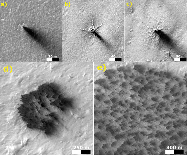
These images, taken at different times and locations, are thought to represent stages in the development of araneiform, or spider-like, terrains near Mars' south pole. Over multiple winters, an initially isolated furrow becomes increasingly dendritic as new tributaries branch off older troughs. Credit: NASA/JPL-Caltech/University of Arizona.
With two rovers patrolling the surface of Mars, six spacecraft orbiting above it, and scientists here on Earth studying the Red Planet from afar, new findings are announced often. Here are a few of the latest updates.
Spidery landforms near Mars’ south pole have puzzled scientists for years, but a new analysis of images collected by the Mars Reconnaissance Orbiter (MRO) sheds light on the features’ origin. Over three Martian years, researchers observed the growth of troughs in the Martian surface believed to be carved by eruptions of pent-up carbon dioxide gas from beneath the dry ice sheet that covers the region during the southern hemisphere winter. Each year, the troughs — linear when they first form — take on increasingly dendritic appearances as new tributaries branch from older troughs, reported Ganna Portyankina of the University of Colorado Boulder and colleagues in Icarus. Given enough time, the researchers suggested, these features, which span tens to hundreds of meters each, could grow and merge into larger araneiform, or spider-like, terrains. Troughs formed the same way have previously been observed in the northern hemisphere, but there, the initial linear features are erased each year, likely due to the greater availability of loose sand near the north pole, which blows into and refills the troughs annually after the seasonal dry ice sheet evaporates.
Buried beneath the surface in Mars’ northern midlatitudes sits a water ice deposit that holds as much water as Lake Superior. Researchers studying ground penetrating radar data collected by MRO’s Shallow Subsurface Radar (SHARAD) instrument reported evidence of the deposit, located in Utopia Planitia, in a new study in Geophysical Research Letters. Water ice is unstable at the surface in the midlatitudes, quickly vaporizing amid the Red Planet’s thin atmosphere, but this deposit — 80 to 170 meters thick and mixed with dust and rocky debris — is protected by up to 10 meters of soil. It “probably formed as snowfall accumulating into an ice sheet … when the planet’s axis was more tilted than it is today,” said lead author Cassie Stuurman of the University of Texas at Austin, in a statement. Its location and shallow depth could make the ice a viable resource for future manned missions to Mars as it is probably more accessible than most water ice on Mars, the researchers noted.
Also using accumulated SHARAD data, researchers have been piecing together detailed three-dimensional pictures of Mars’ northern and southern polar ice caps, an effort that’s revealing previously unseen layering and structures within the ice. The additional layering seen inside the ice caps should help scientists better track how the Martian climate changed in the past, noted researchers led by Frederick Foss of Freestyle Analytical & Quantitative Services in Longmont, Colo., in a study published in the Leading Edge. The data have also illuminated impact craters buried in the ice, some known previously based on surface expressions and some that were unknown. A better accounting of such craters could help scientists more accurately assess the ages of the ice caps.
Among the multitude of intriguing surface features photographed by the Curiosity rover on its traverse across Gale Crater are vertical, cylindrical rock formations up to 70 centimeters in diameter. The formations — not seen elsewhere on Mars so far — sometimes contain concentric internal layering and tend to jut out from surrounding bedrock outcrops, indicating they are more resistant to weathering. In a new study in Geology, David Rubin of the University of California, Santa Cruz, and colleagues compared the cylinders to analogous features observed on Earth, concluding that they likely represent the lithified remains of injections of fluidized sediment that could have been triggered by “impacts, overpressurized fluids, earthquakes, or by collapse into cavities formed by dissolution of evaporites,” the researchers wrote. “These structures are yet another indicator of the importance of aqueous processes in shaping the geology of Mars.”
© 2008-2021. All rights reserved. Any copying, redistribution or retransmission of any of the contents of this service without the expressed written permission of the American Geosciences Institute is expressly prohibited. Click here for all copyright requests.