
by Timothy Oleson Tuesday, May 28, 2013
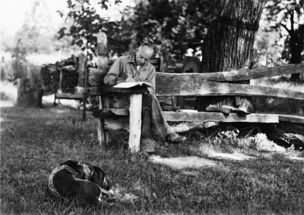
Aldo Leopold writes in his journal while at "the shack," his family's weekend retreat near Baraboo, Wis., where he routinely observed when species of birds returned to the area, when different mammals emerged from hibernation and when flowering plants first blossomed each spring. Copyright Aldo Leopold Foundation
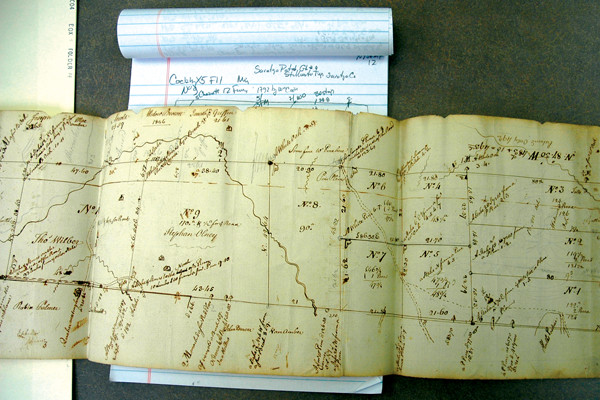
This 1792 survey map, stored at the New York State Archives in Albany, shows plots of land in the area of the Saratoga Patent. Courtesy of Charlie Cogbill
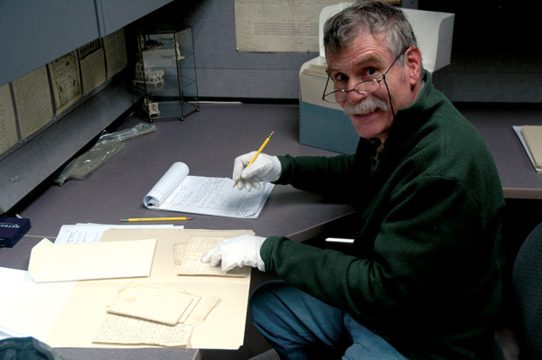
Charlie Cogbill studies land survey records at the New England Historic Genealogical Society in Boston, Mass. Courtesy of Charlie Cogbill

Data mining. Copyright Callan Bentley
“Keeping records enhances the pleasure of the search, and the chance of finding order and meaning in these events.”
Famed naturalist Aldo Leopold and co-author Sara Jones included this simple reflection in a 1947 scientific monograph in which they sought to condense a decade’s worth of ecological field observations from southern Wisconsin between 1935 and 1945. Along with meteorological conditions, these detailed observations — accumulated mostly by Leopold — noted when each spring various species of birds returned, when different mammals emerged from hibernation and when certain flowering plants first blossomed. Like many of his predecessors and contemporaries emerging from the naturalist movement, Leopold kept such records as a matter of habit and because of his passion for the outdoors, but without any scientific application in mind.
Only late in his life did Leopold, who died in 1948, and others begin to recognize that such phenological records, amassed over time, might help answer larger questions of ecology and climate. But even then, he probably did not grasp how important his notes and writing would become, not only as a literary touchstone for environmentalists, but as a significant source of historical data for scientists decades later.
Written records of natural phenomena come from personal journals and diaries, newspaper accounts, ship logs and government documents, among other sources. Such accounts often offer descriptive details and context that cannot be matched by other methods, and they can prove extremely useful in broadening records both temporally and geographically. Given that they predate the sort of widespread instrumental readings that scientists have come to depend on, sometimes there is simply — and literally — no substitute for historical data.
Despite their advantages, historical records are used infrequently in modern physical sciences. That may be changing, however. Some seismologists, for example, have consulted ancient texts and epigraphic inscriptions that predate measurements of ground shaking by seismometers to expand earthquake records. And now, other researchers are turning to historical records to extend climate, weather and ecological records back in time. These documents, they say, offer windows not only to the past, but the present and potentially the future as well.
Nineteenth and early 20th-century naturalists didn’t make observations with research in mind, says Stanley Temple, a senior fellow at the Aldo Leopold Foundation in Baraboo, Wis., and emeritus professor of forest and wildlife ecology who held Leopold’s former faculty position at the University of Wisconsin at Madison. “They were simply … recording the good times that they had in the field.”
Leopold’s habit was to jot down shorthand remarks in his notebook during the day, and then faithfully transcribe his meticulous observations into longhand in journals, Temple says. That routine resulted in thousands of pages of now-archived notes. On any given day, Leopold’s notes would usually start with some comments about the weather, “and then there would be a big section on phenology, things that he was seeing for the first time during the year.”
Leopold and Jones’ 1947 monograph was one of the earliest attempts to make sense of phenological records, Temple says. “Rather than just treating them as a quaint Victorian hobby … these really were scientific data.” And he and other researchers have used them to glean new information for modern scientific studies.
In particular, Temple has focused on Leopold’s 1935 to 1945 observations of when various flowering plant species native to southern Wisconsin, such as woodland phlox and wild geranium, first bloomed in the spring. Combining these data with those of Leopold’s daughter, Nina Leopold Bradley, who resumed her father’s observations in 1977, and his own, Temple found a linear relationship between average annual springtime temperatures and the timing of the plants’ first blossoms.
Basically, the warmer the average temperature from March through May, the earlier the flowers bloom. During the period of the elder Leopold’s observations, the mean date of first bloom for 23 different species was May 7, whereas between 2002 and 2012, when average spring temperatures were 1.8 degrees Celsius warmer than between 1935 and 1945, the mean date was seven days earlier.
Wisconsin isn’t the only place where this trend has been seen. While Temple was sifting through Leopold’s records, others were busy teasing apart similar records kept almost a century earlier by another well-known environmental writer, Henry David Thoreau. From 1852 to 1858, Thoreau noted in his journal when the flowers first bloomed in Concord, Mass. (near the cabin made famous by his book “Walden”). Around the turn of the 20th century, botanist Alfred Hosmer picked up where Thoreau had left off, again noting flowering times. Recently, researchers at Boston University and Harvard University analyzed the two men’s notes, along with modern phenological records, and found that for every 1 degree Celsius of spring warming, the flowers blossomed 3.2 days earlier on average. This equates to an 11-day advance in first flowering times considering average springtime temperatures in Concord are now about 3.3 degrees Celsius warmer than in Thoreau’s day.
Temple recently paired with the team in Boston to jointly publish their results in the journal PLOS One. The researchers noted that, so far, the flowering plants in Massachusetts and Wisconsin are evidently still adapting to change. Whether the trend of earlier blooming dates with local warming will continue is unknown, Temple says.
A major focus of the study was to assess if the records could help determine the predictability of the trend. So, for example, when record-breaking spring temperatures were observed in Massachusetts and Wisconsin in 2012, Temple says, “could we have predicted what would happen to the plants in response?” In short, the answer was yes, thanks in large part to the otherwise unavailable data provided by Leopold’s and Thoreau’s observations, which afforded the researchers with “really strong historical relationships,” he says.
The datasets of Leopold and Thoreau are “remarkable,” Temple says, “in that they aren’t focused on one or just a few species.” Both men recorded hundreds of natural events, he says. “So they give us the opportunity to actually dig into what the consequences are, not only for individual species, but for an entire community, both animals and plants.”
Other written records, such as early land surveys, can also prove useful for putting modern ecology into context. Since the early 1980s, independent historical ecologist Charlie Cogbill has gradually been piecing together a picture of American forests prior to widespread disruption by European settlers. There was, of course, no national forest service or other management body keeping records at the time, but Cogbill has found that land surveys from colonial towns provide a wealth of data on what presettlement forests looked like.
“I try to find various documents — archival documents, public records — that reflect those surveys … maps, a plat of ownership or a property, or a description in a deed,” Cogbill says. For more than three decades, Cogbill has looked at records from numerous towns from Pennsylvania to Maine, including, he estimates, between half and three-quarters of the towns in New England.
“Fortunately,” Cogbill says, surveyors at the time, who were hired by town proprietors to parcel up land prior to settlement of the town, conventionally “used trees as markers on the ground to delimit the corners of the properties.” To identify these so-called “witness trees” in their reports so they could be found again later, the surveyors often made detailed notes not only about the trees’ location and position relative to a corner, but also, importantly, about their size and species. Cogbill has tallied this information for more than 350,000 individual trees. And considering that surveyors typically used the closest tree (or sometimes the closest two or more trees) to a particular corner, regardless of what type of tree it was, the dataset he has amassed provides “a very good, unbiased statistical estimate of what the forest composition was,” he says.
His labor-intensive efforts have revealed a couple of consistent and broad observations, Cogbill says. First, species that are relatively common, and even dominant in some places, today — aspens and red maples, for example — were far less common in the 17th and 18th centuries. Conversely, beech, spruce and others that were more widespread in past centuries have largely been supplanted. It’s not a surprising observation, he says. The species that have seen declines are “major timber species that are commonly found in older forests” and that take a long time to develop, whereas the trees that have proliferated grow rapidly and are resilient in the face of disturbance.
And second, prior to European settlement, there was a clear ecological division, or “tension line,” traversing central New England that separates the northern forest — characterized more by beech, birch, maple and the like — from the southern forests of oak, hickory, chestnut and tulip poplar. “Literally, if you go from about one or two towns to the north to two towns to the south of that line, you get a complete switchover in the overall composition,” Cogbill says. What’s even more amazing, he says, is that “we can still see it.” Despite 200 to 300 years “of land use, of climate [change], of pushing and altering composition,” the position and clarity of the boundary hasn’t changed. It’s unclear why. Perhaps there is just a long lag time for such major ecological features to adjust, he suggests.
Getting a handle on what the forests looked like prior to European settlement is not simply an exercise in nostalgia or academics, Cogbill says. It offers perspective on how much, how fast, and under what influences the forests have been altered, which helps project future changes and inform management decisions, he says. Presettlement forest data provide a baseline, he adds, and “all of this information is very important to informing how we look at dynamics of forests” over time.
There are other lines of data — such as pollen records and old growth forest — that help illuminate how forests in the Northeast once appeared, Cogbill says. But they offer less detail and are far more limited geographically.
One field in which records kept today are undoubtedly more complete than in the past is meteorology. Using data from thousands of weather stations, eyewitness accounts and an assortment of satellites, agencies like the National Weather Service and the National Hurricane Center in the U.S. observe and log modern meteorological events in great detail. But these sorts of thorough records only began in the 19th century. For scientists, engineers and emergency management officials, this short record, comprehensive as it might be, makes accurately gauging changes over time and the likelihood of natural hazards — hurricanes and floods, for example — very difficult.
“A long-term perspective is extremely important to understand the climate mechanisms controlling hurricane activity,” says Kam-Biu Liu, a paleoclimatologist at LSU. The 150-year-long instrumental observation record in the U.S. is “too short to capture the variability or the occurrence of the very rare extreme events” like category 4 or 5 hurricanes that are capable of widespread destruction, Liu says.
Grasping such variability is a big concern for officials designing storm-resistant infrastructure, including hospitals or levees, and big business for insurers and reinsurers who assess risk and scale premiums based on their best understanding of past events. “If you just look at the modern record from the early 1900s on, some places might have a low 3 to 5 percent chance [of getting hit by a hurricane]. If you add 100 or 150 years of data, that can increase up to 8 to 10 percent. And that makes a big difference in the insurance industry,” says Cary Mock, a paleo- and historical climatologist at the University of South Carolina.
The record of past hurricane activity can be extended by using two other sources of data: the geological record and written historical records, Liu says. Most of his work has involved the former. He and his colleagues — early practitioners in the field of paleotempestology — have analyzed lake sediment cores from sites along the coasts of the Gulf of Mexico, Central America and the Caribbean for signs of anomalous sandy layers deposited by hurricane-strength winds and waves during storm surges.
Geologic evidence that records activity over millennial timescales is vital for clarifying the long-term picture, Liu says. However, these records must be dated radiometrically, typically resulting in uncertainties in age estimates for individual events ranging from a decade to several centuries. By contrast, historical records offer the “obvious advantage” of a “much more precise chronology,” Liu says, because they often record the details of an event’s timing.
Liu has used China’s lengthy and well-preserved written history, scouring logs of daily imperial activity and local government gazettes, called fang zhi, from coastal counties that date back to about A.D. 1000 to reconstruct the history of typhoon activity. Counties used these gazettes to record everything from cultural events, like someone passing an examination to become a high-ranking government official, Liu says, to reports of major storms, including the timing and details about storm surge, flooding and damage.
Similar records have been found in a variety of sources in the Western Hemisphere that date to British, Spanish and other European colonial periods. Sometimes, particularly in ship logs and plantation diaries, both Liu and Mock say, you can find detailed, hour-by-hour descriptions of meteorological conditions — wind direction and strength and rainfall intensity, for example — critical data for reconstructing the paths of hurricanes.
Whereas ship logs offer seaward perspectives of a storm, newspapers sometimes recorded meteorological data on land. Newspapers and personal diaries are also useful “for things like storm surge, and the raw land damage and destruction,” Mock says — more of the impact on people. Together, these different types of records from a single event can help map out storm paths.
To quantify a storm’s intensity, it helps to be selective about which details are used from written accounts of damage and to standardize them “with respect to what we know about modern damage,” Mock says. Accounts of buildings being leveled are less useful, for instance, “because we know building practices back then were a little bit different.” But things like storm surge and widespread uprooting of trees are aspects that are consistent with today’s Saffir-Simpson scale, allowing researchers to estimate intensity.
Recently, Mock and his colleagues used materials from 18 separate archives to piece together an in-depth look at the so-called Great Louisiana Hurricane of 1812, which they published in the Bulletin of the American Meteorological Society. Geographic positions and meteorological reports from ship logs, including 12 British naval vessels forming a wartime blockade of U.S. ports, allowed the researchers to plot the storm’s course across the Caribbean, up through the Gulf of Mexico to the U.S. coast, where it made landfall just west of New Orleans on Aug. 19, 1812.
Dozens of newspapers, diaries and ship protests — a sort of insurance claim filed to show that damage to a ship or its cargo sustained during a storm was not due to a negligent crew or captain — also offered detailed descriptions of the damage and chaos that resulted. The team quoted an excerpt from the “Orleans Gazette,” for example, which described how levees had been heavily damaged and that the shore was littered with “fragments of vessels, merchandize (sic), trunks” and other debris. “In short,” they quoted the paper as reporting, “what a few hours before was life and property, presented to the astonished spectator only death and ruin.”
In the study, the team concluded that “a hurricane like the one in August 1812 would rank among the worst Louisiana hurricanes in dollar damage if it occurred today,” and that using the assemblage of historical records had offered “an excellent example of adding mostly noninstrumental data to provide a further understanding of past hurricanes that are directly comparable to those in our modern record.”
The usefulness of details and data contained in historical records extends only as far as their accuracy and veracity can be trusted. To some extent, researchers must take on faith that historical accounts were produced honestly. (Of course, the same could be said of modern scientific results, which, even if measured instrumentally, are ultimately reported by humans.) Even so, human observations are subject to biases, whether intentional or not, that might skew representations of natural phenomena.
“Correction for bias is a big deal,” Temple says. Some of Leopold’s observations of flowering times recorded at “the shack” (the setting for his best-known work, “A Sand County Almanac”) were subject to an obvious “weekend bias,” Temple points out, because Leopold and his family visited the getaway on weekends. (A plant that could have blossomed mid-week would have been noted the following Saturday, for example.) But biases can be accounted for as long as they’re recognized, he says, and the best way to do that is by thoroughly examining whatever documents one is using.
Cross-referencing different sources also helps when possible. Newspapers can be very valuable in terms of reconstructing past hurricanes, Mock says, but they occasionally plagiarized each other and had a penchant for exaggeration, complicating interpretations of storm conditions and damage. By looking at multiple newspaper reports along with other sources describing the same event, these biases are easier to spot. “The approach we take is conservative,” Mock says. “We don’t usually include [records] unless we’re pretty sure about them.”
Statistical analyses are also useful, Cogbill says, particularly for large historical datasets. In his work with witness tree records, “the assumption is that the trees are an unbiased representation of what the forest was like in that locality when it was surveyed.” But “we can’t absolutely prove that every surveyor was unbiased,” he says. Analyses intended to ferret out systematic biases in his data, such as preferences for certain species as witness trees, have shown that any such partialities have not significantly influenced the picture of early forests that he has assembled.
Given the enormous volume of historical documents that relate to ecological, meteorological, climatological or other physical conditions of the past, there is plenty of ground left to mine, researchers say.
“Definitely,” Mock says, there are archived records all over the place. But searching them out is time-consuming and “involves a lot of historian-type work,” which not all scientists are trained to do or are interested in, he notes. Additionally, “the success rate can be kind of low … I can look at 20 [sources] in a day, and maybe only three of them might be any good.”
With the legwork and long odds involved sometimes, it’s not surprising that those who do pursue this work also tend to be interested in the historical narrative or backdrop portrayed in the documents through which they are searching. Cogbill, who has collected records from throughout the northeastern U.S., and is now working with similar surveys from the Midwest, says it is both a pleasure and a challenge to decipher regional vernaculars. The tree species we now know broadly as sugar maple, he points out, was once known by at least three different names — sugar tree, rock maple or hard maple — depending on if the observer was from Pennsylvania, Maine or Vermont. These kinds of intimate cultural details, “which to me are half-educational, half-ecological, and certainly very interesting historically,” abound, he says.
For Temple, who says he has repeatedly gone to the journals of Leopold and other note-taking naturalists “to extract data and find order and meaning” over the years, “it’s been really quite a remarkable adventure getting to know what these guys thought was important to record.” And given how prolific they were, he says, “we’ll be writing papers on these datasets for years to come because there’s so much to explore.”
© 2008-2021. All rights reserved. Any copying, redistribution or retransmission of any of the contents of this service without the expressed written permission of the American Geosciences Institute is expressly prohibited. Click here for all copyright requests.