
by Sara E. Pratt Monday, December 8, 2014
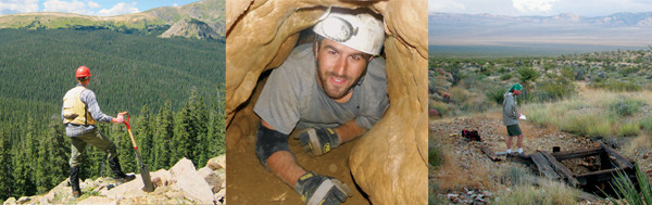
GeoCorps projects can take participants to a variety of stunning work locations. Left: Patrick Burns, a U.S. Forest Service GeoCorps intern, worked in the Fraser Experimental Forest in the Rocky Mountains. Middle: GeoCorps participant Chris Ciervo explores the Snake Creek Cave system in Great Basin National Park in Nevada. Right: Many GeoCorps positions involve mapping abandoned mines, such as this one in Mojave National Preserve in California. Credit: all: GSA.
Applications are now being accepted for spring and summer 2015 GeoCorps America positions. The deadline is Feb. 3 at noon (Mountain Time). Fall and winter positions will be posted on May 1, with an application deadline of noon on July 1. Applicants may apply for up to three positions (although they can only accept one) and must be a member of the Geological Society of America to apply. Below is a sampling of some GeoCorps projects.
[Mosaics in Science Program]
NPS/Glen Canyon National Recreation Area, Page, Ariz.
Research the current distribution and abundance of “special status” bat species.
NPS/Denali National Park and Preserve, Alaska
Conduct hazard analysis to identify, quantify, monitor and report on the most threatening forms of mass wasting along the Park Road corridor.
NPS/Florissant Fossil Beds National Monument, Florissant, Colo.
Assist with ongoing projects relating to the geological and paleontological resources of the monument.
BLM/Craters of the Moon National Monument, Shoshone, Idaho
Conduct fieldwork to complete significant cave surveys on federal lands in order to develop 2-D and 3-D cave maps.
BLM/Colorado River Valley Field Office, Silt, Colo.
Inventory and assess surface water and groundwater resources, water diversions and associated ditch systems in proximity to selenium/saline bearing geology. Field verify and map the infrastructure, and collect data on flow, water chemistry, geologic setting, soils and vegetation as part of a larger effort to reduce selenium, salinity and sediment inputs to the Colorado River.
USFS/White Mountain National Forest, Conway, N.H.
Assist in the collection of natural resource, geological and recreational user information to support agency decision-making on the development of a comprehensive recreational mineral-collecting policy for the forest and site-specific management plans.
USFS/Willamette National Forest, McKenzie Bridge and Westfir, Ore.
Inventory and map springs and wetlands on the McKenzie River and the Middle Fork Ranger Districts.
© 2008-2021. All rights reserved. Any copying, redistribution or retransmission of any of the contents of this service without the expressed written permission of the American Geosciences Institute is expressly prohibited. Click here for all copyright requests.