
by Mary Caperton Morton Wednesday, November 20, 2013
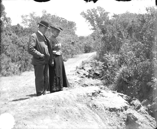
The buttons being in their proper place on the right-hand side of the man's waistcoat indicate that this 1906 photo has not been reversed during the printing process, providing an important clue as to the orientation of the fault trace, seen at the couple's feet. Bancroft Library, University of California, Berkeley
Portola Valley, just south of San Francisco, is famous for its progressive approach to geology. The town was the subject of the first geologic map of California and the first municipality in the state to hire its very own resident geologist. There’s a good reason: The section of the San Andreas Fault that produced the deadly San Francisco quake of 1906 runs right through the town. But where exactly the fault trace lies has long been a mystery. Now, in a new study, researchers have used a combination of new technology and old photographs to relocate the fault line.
“The story of this fault trace reminds me of that game [called “Telephone”] we all played as kids, where one person whispers a sentence to somebody and they whisper it to the next person and by the time it goes around the circle, the sentence has completely changed,” says Ted Sayre, a geologist at Cotton, Shires and Associates, a geotechnical consulting firm in Los Gatos that serves as the “town geologist” for Portola Valley.
“The initial trace reported in 1906 was fairly accurate, but the story kept changing over the years until 100 years later, the maps and reports were no longer true to what actually happened,” says Sayre, co-author of the new study in the Bulletin of the Seismological Society of America.
Sayre and his colleagues traced the discrepancies to hand-drawn maps that had been inaccurately reproduced, as well as several film negatives that had been accidentally flipped during printing, thus producing reversed photographs. The series of mistakes, first published in 1908 and later cited by at least eight different studies, added up to reports of a branching fault trace several hundred meters off the mark, Sayre says.
Mapping was further complicated by heavy brush in Portola Valley, which obscures the ground surface and the fault trace. “Portola Valley is covered with very dense chaparral and thick masses of poison oak,” says Chester Wrucke, a retired U.S. Geological Survey geologist and lead author of the study. “Geologists are a hardy bunch, but even they don’t want to wade around in poison oak,” says Wrucke, who lives in Portola Valley.
To update the location of the fault trace in Portola Valley, Wrucke’s son Robert, an independent computer engineer also based in Portola Valley, used bare-earth lidar technology, which can see through vegetation, to map the area. Then the team overlaid the lidar-generated maps onto the old photos to help pinpoint where the erroneous reports went wrong.
“The new technology is really neat, but it was really the archives that provided the best clues,” says the elder Wrucke. One example of the team’s creative use of archived material comes from a 1906 photo of a well-dressed couple posing near the surface scar: The man’s waistcoat buttons are on the correct side of the coat — the right side — which helped confirm that the photo hadn’t been flipped. But in other cases, skylines and road curves showed that some negatives had indeed been reversed. After years of work, Sayre and the Wruckes determined the exact location of fault, which runs through Portola Valley along a single trace.
Establishing a more accurate location for the fault doesn’t just serve to satisfy curiosity. California has strict codes against building along active faults, says Mary Lou Zoback, a seismologist at Stanford University who was not involved in the new study. “Determining the location of the active trace of major faults is very important, especially in terms of zoning,” she says.
In 1972, in response to the damaging San Fernando earthquake that struck Southern California, the Alquist-Priolo Earthquake Fault Zoning Act was passed to help mitigate the hazards associated particularly with surface rupture. The act forbids new houses and buildings intended for human occupancy from being built within 15 meters of a known active fault trace.
The findings don’t affect the potential shaking hazards for future quake events in Portola Valley, Zoback says. “In terms of the shaking hazard, shifting the fault a few hundred meters doesn’t really make much difference,” she says. “The implications really center around the Alquist-Priolo Act. In a residential area, drawing [15-meter] boundaries surrounding the fault can block out a lot of area.” \
© 2008-2021. All rights reserved. Any copying, redistribution or retransmission of any of the contents of this service without the expressed written permission of the American Geosciences Institute is expressly prohibited. Click here for all copyright requests.