
by Naomi Lubick Wednesday, August 17, 2016

Tourists and glaciologists alike want to get as close to glaciers as is safely possible. Credit: Gary Bembridge, CC BY 2.0 Credit: Gary Bembridge, CC BY 2.0.
Any tourist bound for Greenland or Alaska on a cruise ship would be happy to capture video of a huge chunk of ice as it calves from the face of a glacier hundreds of meters tall or more — filmed from a safe distance of course. When it hits the ocean below, falling ice can send up cascading walls of water that could capsize or drown any vessel that dares too close.
Researchers would be just as glad to get those images, to see what is happening with the ice, particularly at the front of glaciers where ice meets seawater. Glaciologists also want to know what’s happening at the inaccessible bottom of the ice, hundreds of meters below the surface where it meets the rocky bed, and at the top of the ice in deep crevasses and freezing glacial ponds.
None of these places are easy or safe to get to, but these interfaces may be key to what happens to the flow of a glacier or even an entire ice sheet. And while satellites may capture an overview, it’s worth getting closer to examine smaller-scale features. So researchers have figured out how to get close, to monitor ice from the tops of melt ponds, in deep crevasses, and below ice sheets where the ice meets the sea or bedrock, without visiting the edge of the ice themselves: They send instrument avatars.
An automated kayak, laser sentries and even GPS-tracked sensors the size of ping-pong balls now can capture data quickly, or collect it over days or weeks and even months, long after their human creators have deployed them. An automated autonomous monitoring revolution has been made possible, researchers say, by the increasing availability of small, off-the-shelf devices with ever-shrinking power sources and growing memory.
What they have found so far is surprising, and it’s just the tip of the iceberg.
“Glaciology used to be a glaciologist walking out, putting out a stick [in the ice] and coming back in a year,” says Fiamma Straneo, a glaciologist at the Woods Hole Oceanographic Institution (WHOI) in Massachusetts. While researchers still sometimes drive poles into the ice to measure snow accumulation or track surface movements over a season, today, satellites provide the bulk of the data on the sea ice, glaciers and ice sheets that make up Earth’s cryosphere.
Satellites such asace Agency’s CryoSat-2 and NASA’s ICESat have collected reams of data that show the big picture: Launched in 2010, CryoSat-2 uses synthetic aperture radar to measure the height of the ice to determine the thickness of the polar ice sheets and sea ice. Starting in 2003, ICESat used laser altimetry to measure ice, clouds and land surfaces until it shut down in 2010.
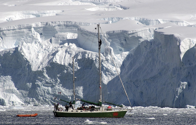
Tourists and glaciologists both want to get as close to glaciers as is safely possible. Here, researcher Alun Hubbard's ship sails in Paradise Bay, Antarctica. Credit: Tim Hall.
Its successor, ICESat-2, is set to launch in 2017 and will measure ice elevation at the centimeter scale. Since 2003, ICESat has been one of the richest sources of detailed ice data from a satellite’s point of view, says Mark Fahnestock, a geophysicist at the University of Alaska at Fairbanks; it led to the first estimates of Greenland’s ice mass and glacial thinning, and captured data that revealed of some of the first big breakups of Antarctic ice.
“In the last 30 years, satellites have really revolutionized ice measurements,” Straneo says, but these measurements only track the visible parts of the ice. It’s the parts that can’t be seen and where researchers have the least data that may prove most important, she says. No matter how small-scale and precise a satellite image can get, it’s no substitute for “boots on the ground” — even if those “boots” belong to a robot.
For example, satellites bearing laser altimeters and radar still can’t see to the bottom of the rocky bed below the ice. Plus, satellite radar can’t “read” water properly from afar — it takes fieldwork to ground-truth what the satellites have seen. Nor can satellites see what’s happening in the water where glaciers at the edges of ice sheets are heading for the sea. “For Antarctica and Greenland, we need really to understand what the ice is doing” where it meets the ocean, Straneo says.
But getting there might take helicopters, which are expensive to secure and challenging to operate and land in an ice field. Or, perhaps, reaching a glacial front may take a trip aboard sleds, which are tricky to navigate, especially when a wrong turn can lead into a crevasse and put lives and equipment in danger. Or it could take boats to get to the ice, which often entails going out in frigid choppy seas and endangering personnel and instruments.
At least, it used to.
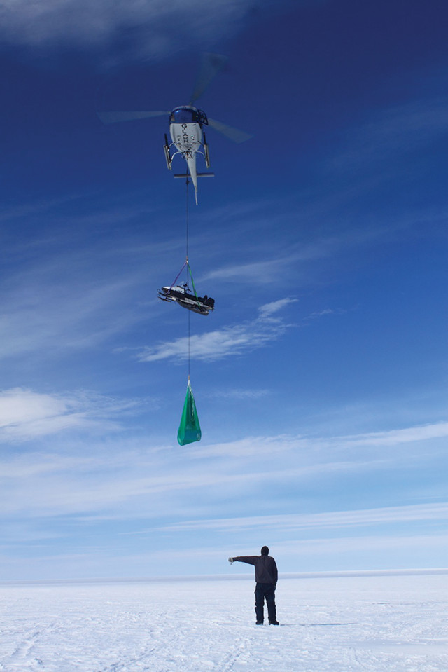
Helicopters are necessary to get people and equipment onto ice sheets, but they are expensive to secure and challenging to operate and land in an ice field. Credit: Sam Doyle.
Doyle, a glaciologist at the University of Maine who collaborates with Straneo. In the past two years alone, he says, leaps in technology have allowed researchers to do so much more. In the 1990s, glaciology saw similar advancement when GPS came on the scene, which dramatically improved measurements of ice movement. Today’s leaps are possible because of improvements in telemetry, computing power and data storage, which have emerged alongside more reliable power sources such as longer-lived batteries and more efficient solar cells.
“Without any tending once they’re launched, this generation of small devices can take photos every few seconds or minutes and collect and save massive amounts of quantitative data. That information can be collected later or sometimes even forwarded in near real-time to researchers at a distant, safe vantage point — on a nearby stable mountainside or a ship, for example.
“There are things we can measure now that we couldn’t before because we couldn’t build an instrument that would operate autonomously long enough to see” what researchers wanted to see with high spatial and temporal resolution, Hamilton says. Having a robot or other monitoring device “opens up a lot of projects that we’ve been interested in doing,” he says, and it does so without the need to put humans in danger.
“These game changers can take many different forms, from costly drones — aerial, surface or underwater — to cheaper joystick-controlled motorized kayaks and even tiny instrumented spheres designed to be disposable.
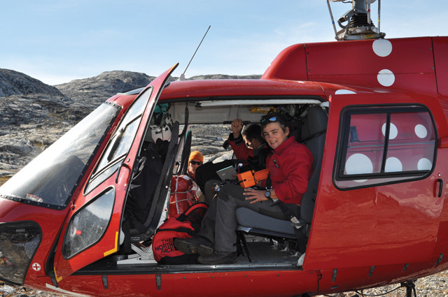
Fiamma Straneo boards a helicopter for summer fieldwork in Greenland. Credit: Fiamma Straneo, WHOI.
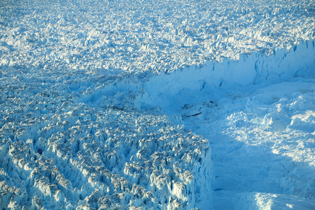
The surfaces of ice sheets are not necessarily flat or easy to traverse. Likewise the termini of ice sheets and glaciers can be dangerous; for example, where the terminus of Greenland's Helheim Glacier meets the ocean, a dense, unstable melange of icebergs, sea ice and snow floating on the water is created. Credit: Ari Daniel.
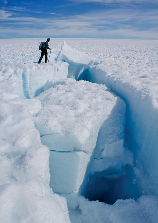
Traversing ice sheets can be exceptionally dangerous for humans, whether on foot or on sleds. Credit: Sam Doyle.
Singh, now also affiliated with Northeastern University, equipped a sea kayak with a personal watercraft motor. Singh then worked out how to mount scientific instruments aboard the kayak and how to drive it with a remote control joystick. The result, which cost about $15,000, was a semi-autonomous vehicle that could be driven up to the edge of a glacier, or used for other applications like studying coral reefs in shallow water.
Straneo, Singh and their colleagues took a prototype out for the first time in summer 2013, to measure the glacier in Greenland’s Sarqardleq Fjord. They deployed the Jetyak from a small boat, floating nearby as the Jetyak headed toward the ice. “We were able to bump literally into the glacier, and we haven’t been able to do that before,” Straneo noted in a WHOI video about the Jetyak. And they could do that while measuring seawater conditions and mapping the underwater ice at Greenland’s edgewater glaciers with radar, for five or six hours an outing until the Jetyak’s rechargeable batteries were drained. They also collected data on the seafloor and mapped a plume of muddy debris from the outwash at the front edge of the glacier. The scientists wanted to get detailed data in particular on the warmth of the water and mud plume to see how it might be driving melting and the flow of the glacier. Results from their field excursions will be published this fall, Straneo says.
With smaller, cheaper tools such as these, “we’re seeing things that we didn’t really understand before,” Hamilton says. “Glaciers are way more complicated than we imagined, [and we are] playing catch-up to understand the behaviors we are seeing.”
Some glacier-oceand behaviors were already understood, for example: A glacier that flows out into the water might accelerate because of increased melting of the terminus from warming oceans, which takes the brakes off the ice farther inland. Or meltwater under an ice sheet on land might act like a lubricant, lessening friction on the bedrock below and greasing the ice’s path so it travels faster into the sea.
But these aren’t the only mechanisms behind changes in glacial velocities. The most basic oceanic interaction marine glaciers have is with tides. Researchers have tracked how a glacier’s front rises as the ocean rises with the incoming tide, for example. By itself, that’s not surprising, Hamilton says. But he notes that with the new data collected with a laser scanner his group set up overlooking a glacier in Greenland, “we can also see that the tide causes the glacier, some kilometers from the terminus, to speed up and slow down.” The change in horizontal speed between low and high tide is on the order of 4 percent, he says. The up and down movement at the terminus, or end of the glacier that hits seawater, seems to flex the ice inland as far as a hinge point where the ice is fully grounded on bedrock.
The Jetyak, shown here at the mouth of West Greenland's Sarqardliup Glacier in 2013, is an autonomous sea kayak outfitted with a personal watercraft motor that can be operated remotely by joystick. It can approach all the way to the edge of an ice sheet but doesn't cost so much that researchers worry about losing it. Credit: both: Fiamma Straneo, WHOI.
“Glaciers respond immediately to tides, and Hamilton says that the implication is that small climatic perturbations to sea-level rise can also have an immediate impact on glaciers. If a glacier is entering 1,000-meter-deep water, the tides might change that depth by a meter or two. That change amounts to just one-tenth of a percent. But that small rise in sea level “makes quite a difference” in the velocity of an ice sheet, Hamilton says, even up to 10 kilometers inland. “That shows you just how sensitive glaciers are to relatively small changes.”
The laser setup developed by Hamilton and his colleagues at the University of Maine and the U.S. Army Corps of Engineers Cold Regions Research and Engineering Laboratory can detect those small changes precisely: Mounted in a tower that stands a bit taller than a person, permanently anchored in bedrock on a nearby mountainside overlooking the ice, the laser, called ATLAS (Autonomous Terrestrial Laser Scanner), scans a 50-square-kilometer area of the glacier every six hours when it is unattended, and every 30 minutes when researchers are onsite. That rapid-succession data gathering at high resolution helps to quantify ice flow and iceberg calving at the centimeter scale (finer resolution than is available from satellites, at least until ICESat-2 comes online). Hamilton says the scanner can operate for months without tending.
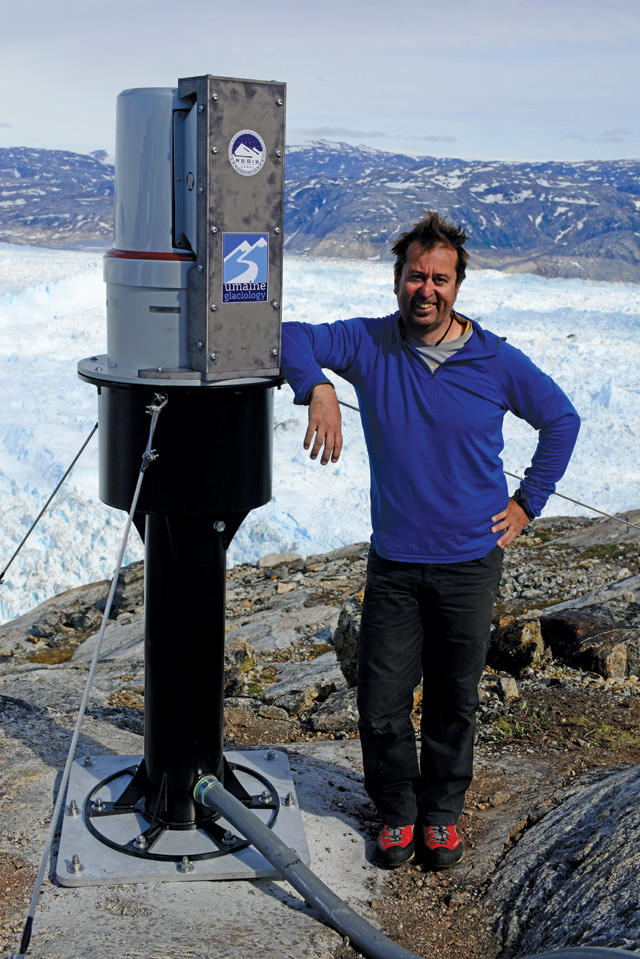
Gordon Hamilton and his colleagues at the University of Maine and the U.S. Army Corps of Engineers Cold Regions Research and Engineering Laboratory created a new sentry to measure glacial change: ATLAS (Autonomous Terrestrial Laser Scanner) stands on a hillside overlooking a glacier and scans a 50-square-kilometer area of the glacier every six hours when it is unattended, and every 30 minutes when researchers are onsite. Credit: Adam LeWinter.
Some monitoring devices aren’t simply left alone: They may be deployed with the intention that they will get “lost.”
Alun Hubbard, a glaciologis University in Wales, and his colleagues deploy small GPS trackers that look like handheld stopwatches and report their locations via satellite. The researchers have dropped these GPS trackers by unmanned aerial vehicles, or drones (which are cheaper than a helicopter and have a smaller environmental footprint), on a glacier front, and used them as “expendable calving front trackers.” Hubbard and his team also developed ping-pong-ball-sized instruments, which, at about $50 per unit, are relatively cheap and therefore disposable. Hubbard’s team has tossed the instruments into crevasses atop Greenland’s ice sheet to track the flow of meltwater down through and under the ice. Along the way, the instruments measure temperature, pressure and conductivity. Hubbard has even been able to collect some of them weeks later after they have made their way to the sea.
Hubbard and his colleagues used GPS and other data collected with these instruments to show that Greenland ice as far as 140 kilometers inland sped up in summer 2011. Using these data together with rainfall measurements from weather stations and satellite observations, as well as water pressure measurements from the ping-pong-ball-like instruments, Hubbard and his team proposed that late summer rains in 2011 amplified meltwater production and the velocity of the ice sheet that year.
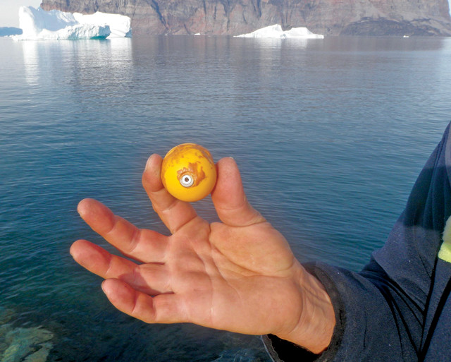
Hubbard holds one of the "disposable" ping-pong-ball-sized instruments he deploys on glaciers to track and investigate glacial meltwater pathways and hydrological systems. Credit: Alun Hubbard.
Hubbard also has experimented with drones for getting high-resolution images of the ice surface. Simple remote-controlled aircraft equipped with off-the-shelf cameras may seem unsophisticated and inefficient compared with bigger drones that can carry large high-tech instruments, such as the converted Predator aircraft that NASA plans to use to study ice sheets with radar in the future. Smaller drones can spend mere minutes to hours aloft on a single flight versus the Predator drone’s 20-hour aloft time, and they need more time to cover relatively smaller areas. But small, off-the-shelf models are far more affordable: A high-end former military machine, valued at millions of dollars, would be expensive to lose and replace, whereas smaller drones and cameras cost as little as several hundred dollars. These drones can also drop GPS monitors on the ice, with little risk to humans and no need to hire a helicopter.
Johnny Ryan, a graduate student working with Hubbard, has used a fixed-wing drone equipped with a 16-megapixel camera to investigate the dynamics of Store Glacier on the coast of western Greenland. The calving front of the glacier was surveyed every day between May and July 2014 to monitor calving events and velocity changes during the melt season to understand how future climate change might affect the volume of ice delivered into the oceans. In a video blog post, Ryan described waiting anxiously for the small plane, which cost about £6,000 in 2014, to return as it took its first self-piloted flights. But as the days passed and he grew comfortable with the aircraft’s reliability, he’d head back to his tent to relax until the plane returned from its scheduled flights over the ice.
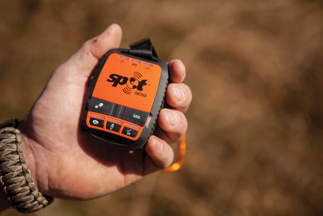
Hubbard drops small GPS trackers like these handheld SPOT trackers on glacier fronts to track calving. Credit: SPOT LLC.
Ryan and Hubbard are also using drones on their work with Jason Box, a glaciologist with the Geological Survey of Denmark and Greenland, and his Dark Snow Project, which is looking what changes the albedo of the Arctic ice surface and how it will change with future climate change. They have determined that reduced ice albedo seen by satellites isn’t just caused by soot or particulate matter that absorbs sunlight and causes the ice to melt faster. Such cryoconite — soot, rock dust and microbes that build up to coat small pockets in the ice — actually only changes the ice albedo over tiny areas, Box and his colleagues are finding. Instead, most “darkness” comes from meltwater pools, crevasses and impurities in an ice sheet, all of which lower the ice albedo. That feeds into further temperature changes and melting locally — and eventually to larger ice-sheet changes, Hubbard says.
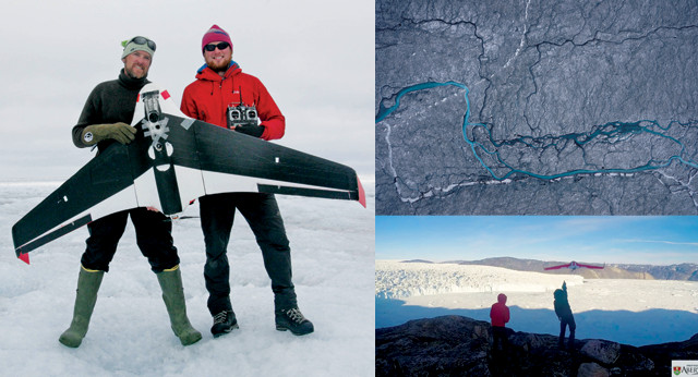
Above: Jason Box (leyan (right) use the Aberystwyth University X9 fixed-wing UAV on the Greenland Ice Sheet. This DIY drone can carry a range of instruments and cameras and was specifically developed by Hubbard, Ryan and Neal Snooke at Aberystwyth for cost-effective, long-range monitoring of flow and calving dynamics and surface properties over the ice sheet. Here it is being used to track albedo changes in support of the Dark Snow Project. Top right: Aerial photo taken by the drone over the Greenland Ice Sheet, showing ice darkened by meltwater, dust, ice algae and wildfire soot. Bottom right: Ryan and fellow graduate student Nick Toberg of Scott Polar Research Institute launch the fixed-wing drone to investigate iceberg calving from the 5-kilometer-long, 100-meter-high front of the Store Glacier in Greenland. Credit: clockwise from above left: ©2015 Dark Snow Project; Johnny Ryan; Alun Hubbard.
More earthbound robots, such as the Yeti — which looks like a toy tractor pulling a snow tube — have been deployed in the Antarctic by Hamilton and others to search for crevasses out on the ice “highway” that leads from McMurdo Station to the South Pole Station. The road traverses the McMurdo shear zone: The ice here is at the inner edge of the Ross Ice Shelf, trapped between it and the Transantarctic Mountains before the high Antarctic plateau, and researchers must cross the shear zone with gear and equipment. The Yeti’s sub-ice radar maps show where it’s safe to drive — and have also uncovered anomalies in how the crevasses form, crisscrossing at odd angles; these strange shapes need further research, Hamilton says, and might indicate different directional pressures at different times in the ice. He would rather send a robot to make these measurements than put people in danger above the shear zone’s icy melange.
But robotic stand-insble, nor are they all-seeing. They can sometimes miss events a human would see, and they need humans to ground-truth what they do see. It’s the same for satellites, which will eventually again surpass the capabilities that current off-the-shelf devices offer, Hamilton says. “Incredibly detailed satellite images” already have become available in the past five years, as companies put up small “box” satellites, such as CubeSats the size of a large grapefruit, with devices that can scan Earth’s surface at 40-centimeter resolution and in stereo. That’s a vast improvement over, say, Landsat images, which represent several decades of monitoring, but have spatial resolutions of 30 meters or more.
Ultimately, thoroughly addressing all of the questions that scientists are asking about the cryosphere – how and why ice sheets and glaciers are behaving in the ways that they do, how this behavior is connected to the oceans, and how meltwater and ice-sheet dynamics all come together to feed into the future of sea-level rise and vice versa – will take contributions from satellites, weather stations, underwater vehicles, and autonomous craft collecting airborne radar, high-resolution photography and video, and tools that haven’t even been invented yet. “This is one of the most challenging places to be working today. All of us are scrambling” to get measurements of any kind, Straneo says, from whatever equipment is available, whether it’s expensive and retrievable or cheap and disposable.
In the meantime, the current generation of remote-controlled and autonomous robots has afforded researchers many new insights and answers, and offers a blueprint for developing ever-more functional tools moving forward. “The stuff we’re doing now wouldn’t have been possible” just two years ago, Hamilton says. “It’s all evolving very fast.”
© 2008-2021. All rights reserved. Any copying, redistribution or retransmission of any of the contents of this service without the expressed written permission of the American Geosciences Institute is expressly prohibited. Click here for all copyright requests.