
by Mary Caperton Morton Tuesday, April 10, 2018
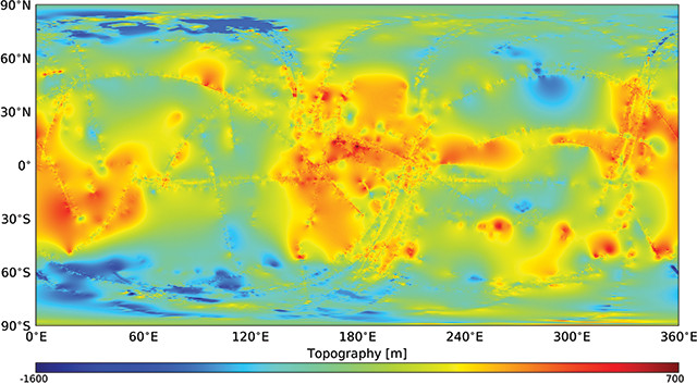
Images of Titan captured by NASA's Cassini spacecraft have been used to create a new global topographic map of the Saturnian moon. Credit: Corlies et al., Geophysical Research Letters, December 2017/Cornell University.
Before NASA’s Cassini mission, which ended in 2017 after 13 years orbiting Saturn, little was known about the surface of the planet’s largest moon, Titan, as most of its features lie obscured under a dense, opaque atmosphere composed mainly of nitrogen gas. However, thanks to special filters that enabled Cassini’s cameras to see through the haze, the spacecraft captured high-resolution images of about 9 percent of Titan’s surface, with 25 to 30 percent of the moon imaged in lower resolution. Researchers have now used an algorithm to interpolate the remainder of the moon’s surface and create the most complete global topographic map of Titan yet.
In a study in Geophysical Research Letters, Paul Corlies of Cornell University in New York and colleagues described some of the features of the newly mapped moonscape, including low-rising mountains — none higher than 700 meters — and two depressions in the equatorial region that may be either dried-up seas or flows from cryovolcanoes, which spew methane, ammonia or water instead of molten rock.
According to the researchers, the map — which, along with the Cassini dataset, is available online — should be useful to scientists studying Titan’s climate, gravitational fields and the evolution of its surface landforms.
© 2008-2021. All rights reserved. Any copying, redistribution or retransmission of any of the contents of this service without the expressed written permission of the American Geosciences Institute is expressly prohibited. Click here for all copyright requests.