
by Lucas Joel Monday, June 19, 2017
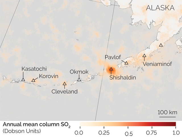
Volcanic sulfur dioxide emissions measured by the Aura satellite are shown in shades of orange in this map of Alaska's Aleutian Archipelago. Credit: Jesse Allen/NASA Earth Observatory.
Volcanoes may not always be erupting ash or lava, but that doesn’t mean they’re not venting other materials. Many, in fact, continuously spew gases like carbon dioxide and sulfur dioxide into the air. In a new study, volcanologists compiled data tracking such releases, collected by NASA’s Aura satellite, into the first global map of volcanic sulfur dioxide emissions.
“Volcanoes are continuously releasing quite large amounts of gas, and may do so for decades or even centuries,” said Simon Carn, a volcanologist at Michigan Tech and lead author of the new study in Scientific Reports. “Because the daily emissions are smaller than [from] a big eruption, the effect of a single plume may not seem noticeable, but the cumulative effect of all volcanoes can be significant. In fact, on average, volcanoes release most of their gas when they’re not erupting.”
According to researchers, mapping sulfur dioxide releases will help in eruption forecasting, climate modeling and other efforts. For instance, changes in the ratio between carbon and sulfur gases released can be a warning sign of an impending eruption. Also, when emitted to the atmosphere, sulfur dioxide gas can react with oxygen to form sulfate aerosols that reflect incoming sunlight back into space, causing a climate cooling effect. By closely tracking the 20 million to 25 million tons of sulfur dioxide emitted from volcanoes each year, climatologists may be better able to model the cooling effects of sulfate.
© 2008-2021. All rights reserved. Any copying, redistribution or retransmission of any of the contents of this service without the expressed written permission of the American Geosciences Institute is expressly prohibited. Click here for all copyright requests.