
by Lucas Joel Wednesday, November 18, 2015
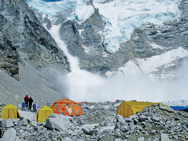
People at base camp on Everest — shown here during an avalanche in 2013 — felt the shaking of the April 25 Gorkha quake, which was followed by an enormous avalanche that killed 19 people. Credit: Deana Zabaldo, CC BY-NC-ND 2.0.
Base Camp, Mount Everest, April 25, 2015, about noon: A tremendous boom echoes through the air, the ground heaves and a wall-like cloud of snow propelled by an avalanche advances toward the tents. Mountaineers scatter, diving into tents to avoid the blast. One mountaineer has a video camera and captures the whole thing, as he curses and dives into a tent while the cloud of snow engulfs him. He survives, but 19 others perish. This firsthand account of the Gorkha quake is now famous, caught on camera and posted to YouTube.
A few hundred kilometers away, Ben Erdmann, a professional mountaineer from Alaska, stands at about 6,000 meters elevation on the north face of Annapurna I. He and fellow professional mountaineer Don Bowie take in the view. Another member of their party, Jess Roskelley, is asleep in his tent. Suddenly, the ground starts shaking. Camped on a lateral moraine in a basin, they are surrounded by roughly 3,000 meters of serac, or ice blocks, stretching up the sides of the mountain.
“It was like the [expletive] apocalypse up there, it was so [expletive] intense — hundreds of avalanches were triggered all at once,” Erdmann says. Everyone ran to a flat part of the moraine and, as the mountain came alive, all were thrown on their backs as the ground rocked back and forth for about 45 seconds. All three survived, but found themselves stranded.
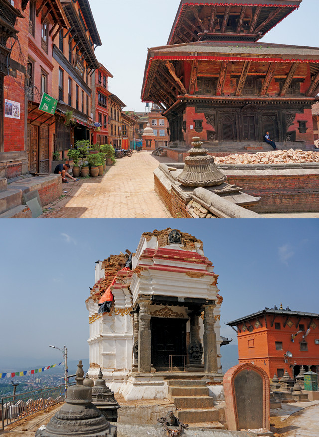
Damage was minimal in Thamel, a popular tourist area in Kathmandu that has newer buildings. Damage was more substantial in older parts of town where there are many ancient masonry temples. Credit: both: Susan Hough.
The avalanches at Everest, Annapurna I and elsewhere in Nepal that Saturday were triggered by a magnitude-7.8 earthquake that struck at about 11:56 a.m. local time near the Gorkha District, about 80 kilometers northwest of Kathmandu, the country’s capital. The quake resulted from stress release along the boundary between the Indian and Eurasian tectonic plates, which began colliding about 55 million years ago, uplifting the Himalayan Mountains in the process. The rupture on April 25 propagated along a horizontal section of the plate boundary about 15 kilometers below the surface. And since then, the mainshock has been followed by hundreds of aftershocks up to magnitude 7.3.
About 8,900 people died and more than 500,000 homes were destroyed, mostly in rural villages, where houses, constructed mainly of stone with little to no mortar, are not built to withstand shaking. Although the loss of life and the damage from the Gorkha quake were severe, many scientists suspect it could have been far worse.
<“iv> “When I first heard about the quake, I thought it was going to be all our worst fears realized,” says Susan Hough, a seismologist with the U.S. Geological Survey (USGS) in Pasadena, Calif. Kathmandu, a city of about 2 million, is located in a valley filled with dry, loose lake sediments. When seismic waves hit a low-density substrate such as this, the waves slow down, bunch up and, as a result, are amplified. This causes more shaking and, typically, more damage, compared to waves traveling through solid rock. Kathmandu, scientists thought, would not do well if a large quake struck.
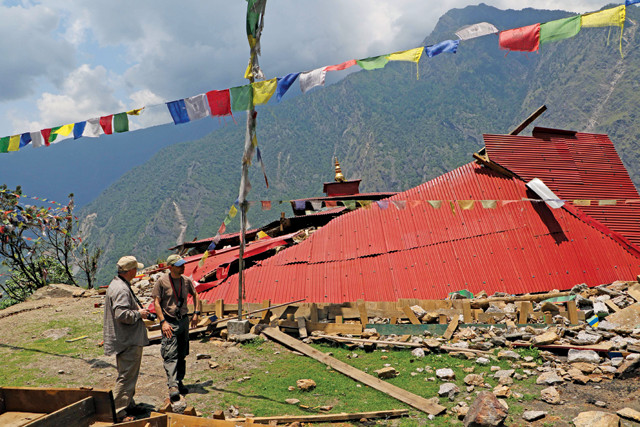
The earthquake caused heavy damage to shrines and other structures in rural areas, including this structure northeast of Kathmandu. Credit: USGS.
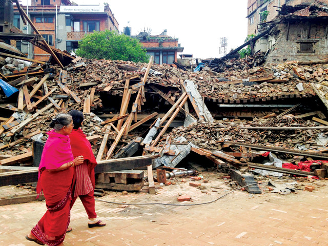
Bhaktapur was devastated in the earthquake. Credit: USAID Photo, Natalie Hawwa, CC BY-ND 2.0.
Initial expectations were that the death toll could reach into the tens, if not hundreds, of thousands, Hough says. But right away there were indications that it wasn’t as catastrophic as people had feared, she says.
On the whole, the Kathmandu Valley appears to have dodged a bullet for two reasons, which are still being studied: the first has to do with the nature of the earthquake; the second is how the sediment in the Kathmandu Valley responded to the quake.
<“iv>”” “The way the earthquake broke was, in a general sense, smooth enough that it didn’t create a lot of jittery shaking,” Hough says. “It happened on a horizontal part of the plate boundary,” she says, “and most of the rupture apparently did not generate much high-frequency energy — the kind of shaking that would have been more damaging to local structures. Most of the high-frequency energy came from the northern edge of the rupture, which was relatively far away from Kathmandu.”
Also working in the Kathmandu Valley’s favor was the behavior of the lake sediments in the valley, which did not respond as predicted, possibly due to the size of the quake. Relatively smaller earthquakes — between magnitude 3 and 5 — are primarily what has been used to model how the sediments respond to seismicity. But “when you have very big earthquakes [like the Gorkha quake], the ground essentially stops acting like a regular, elastic solid,” Hough says. “The sediment is unable to transmit the energy as efficiently or in the same way” as it would during a small earthquake, because higher quake intensities alter the material properties of the sediment, producing different kinds of shaking than might have been predicted.
Because of these factors, buildings in Kathmandu fared relatively well. Hough, who flew to the city shortly after the quake, says that, as her plane descended, it was difficult to tell that anything had happened. “There was damage to some temples and other historical structures in religious centers like Kathmandu’s Durbar Square,” Hough says. “But for the most part — for maybe 95 percent of buildings — there were no outward signs of structural damage.”
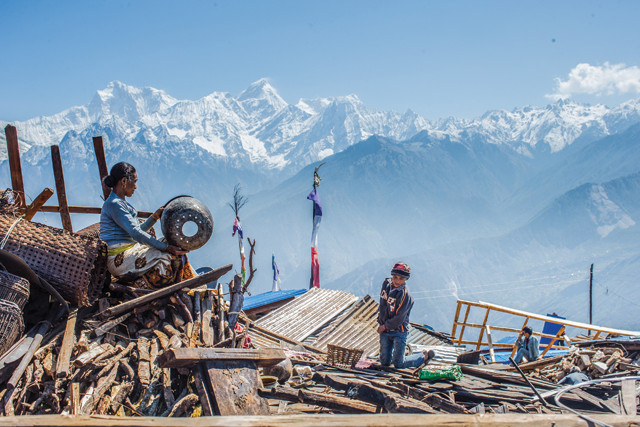
The quake destroyed much of the village of Singla. Credit: Asian Development Bank, CC BY 2.0.
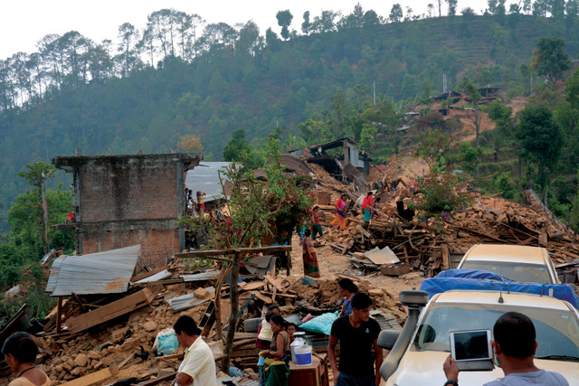
Villages in Dhading District were destroyed and many roads were impassable. Credit: ILO, Shukuko Koyama, CC BY-NC-ND 2.0.
Erdmann, who says he usually prefers climbing less well-known peaks, wasn’t initially planning to summit Annapurna I, a mountain near Nepal’s second-largest city, Pokhara, last April, but he decided at the last minute to join his buddies. Even without earthquakes, Annapurna I is treacherous. Almost 200 people have summited the mountain; 67 have died in the process. On the expedition of the team ahead of Erdmann’s last spring, two mountaineers died, and 12 others were temporarily lost in storms and lost fingers and toes to frostbite but survived.
“It was already a pretty darn intense experience,” Erdmann says. Then the quake hit.
The team had flown in by helicopter to the base of Annapurna I because hiking in to the base camp is difficult and time-consuming. After the quake, however, every helicopter in Nepal was helping with earthquake relief. Via satellite phone, Erdmann and the others began hearing what had happened in the rest of the country. “It was a no-brainer for us. There was no way we could continue to climb while there was so much devastation below.”
With no helicopter coming, the team trekked out of the mountains. It took almost a week of 18-hour days to reach Pokhara. The quake had loosened the seracs, which frequently fell around the team as they descended the mountain pass, Erdmann says. “When we flew in and saw the terrain, we said: ‘If you had to walk out of here, you’d be [expletive]!’” he says. But with no other option, “that’s what we did: We climbed down to the nearest river valley and took it to the nearest road, which was destroyed by landslides, and we took that to the nearest village, which was devastated.”
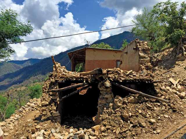
A crumbled house in Mamti Danda. Credit: Ajay Sitaula.
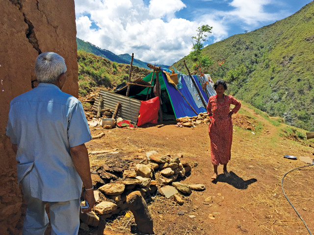
After the quake, people in villages like Mamti Danda lived in makeshift tents. Credit: Ajay Sitaula.
After arriving back in Pokhara, Erdmann’s team knew they wanted to help with relief, but they didn’t know what to do. “All of us are professional climbers, but none of us are philanthropists or doctors,” Erdmann says. They did, however, each have specialties that would come in handy: Erdmann is internationally certified in building extrication, industrial rigging, hazmat response, confined space entry, and has served as a firefighter. Roskelley is a structural welder and welding instructor, holds a commercial driver’s license as a heavy equipment operator, and holds certifications in metal and structural integrity. And Bowie is an EMT with certification in incident command and technical rigging. Furthermore, as professional athletes, they had a platform and a social media presence. They knew they could raise money back home, so they started a fundraiser and raised about $30,000 within a few days.
With support from a Pokhara-based nongovernmental organization run by paragliders called Karma Flights, Erdmann, Roskelley and Bowie used the money they’d raised to rent two old Jeeps. Loading them with more than two tons of basic foods — rice, lentils, salt and oil — they set off to deliver the provisions to villages in the Gorkha District, which, being near the quake’s epicenter, was one of the hardest-hit regions.
“nbsp; "
“The whole experience paralleled [a well-known] mountaineering motto about having confident uncertainty about what you’re getting into,” Erdmann says. “We had no idea what we were getting into.”
Multiple villages in Gorkha, including one called Barpak, were nearly destroyed by landslides. A group of 15 relief workers trying to reach the villages had recently been killed by a landslide triggered by an aftershock, Erdmann says. But with the skills he and his team learned as mountaineers, including the ability to assess and navigate tricky terrain, the trio was among the first to reach cut-off villages like Barpak, and report the conditions there.
The team ended up being asked by the U.N.’s humanitarian relief responders to go to any village they could get to, find landing zones for supply helicopters, and send the zones’ latitude and longitude coordinates to the U.N., Erdmann says. “Our team, it turns out, was the first response and the first eyes on the ground in those cut-off villages.” For the next few weeks, the mountaineers traveled to multiple villages — more than a dozen in all — radioed in to the U.N., and coordinated the delivery of needed supplies — food, medicine, water, tarps, blankets and more — by helicopter, within a few hours of the team’s arrival in a village.
Meanwhile, the U.S. Agency for International Development (USAID) sent a Disaster Assistance Response Team to the region a few hours after the quake struck. The team coordinated relief efforts along with Nepal’s government and the United Nations. Many communities also received advanced disaster training through the Community Action for Disaster Response (CADRE), a program supported by USAID and run through the American Red Cross and the Asian Disaster Preparedness Center. While Erdmann and his fellow mountaineers were trekking in relief supplies and working with the U.N., about 700 CADRE members, trained in life support and light search and rescue, were setting up incident command centers across the country to help coordinate those relief efforts.
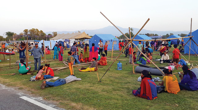
International Organization for Migration relief workers set up a camp for people whose homes were destroyed in Chautara, Sindhupalchok. Credit: ©IOM, 2015, CC BY-NC-ND 2.0.
In the weeks after the quake, while aftershocks were still rocking the countryside, people in many villages were sleeping under tarps, either because their homes were destroyed or they were too afraid to go inside. But focus soon shifted to rebuilding. Ajay Sitaula, an engineer who is a native of Nepal but now lives in Colorado — where he was when the quake hit — helped deliver tin roofing about a month and a half after the quake so people could start building more permanent residences. “Even if you have the money, it’s not easy to obtain roofing materials because the demand is so high,” Sitaula says. Along with his wife, Beth Pratt-Sitaula — a geohazards education specialist with UNAVCO — Sitaula was able to provide roofing for four villages for about 90 different families. With the new housing constructed, the villages began rebuilding, but “everyone in the villages [now] knows that traditional housing practices are not the way to go,” he says. Instead, “we are optimistic” that villagers will retrofit their new homes using simple techniques, such as securing stone walls with wire mesh, which can help prevent the walls from crumbling as easily, Sitaula says. Pratt-Sitaula adds that concerted public education and material support from government and/or aid organizations will be necessary for widespread adoption.
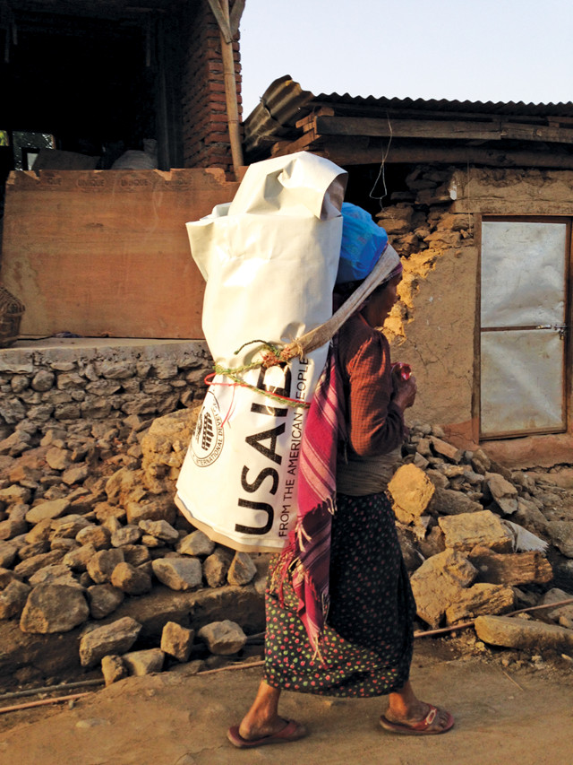
USAID handed out plastic tarps to provide residents with some shelter from the elements in villages such as Sankhu. Credit: USAID.
Nepal has long been at high risk of damaging earthquakes and has experienced many in its history. In 1934, for example, a magnitude-8 tremor killed more than 10,000 people. With that history in mind, some buildings — in villages and cities — have been built with seismic standards in mind. But earthquakes are unpredictable, and convincing most people to invest in earthquake preparedness can be challenging — especially in a poor country like Nepal.
The National Society for Earthquake Technology (NSET) — a Nepalese NGO that launched in the mid 1990s with funding from GeoHazards International (GHI) and USAID that now has more than 100 employees — had been working before the Gorkha quake to prepare the country for future quakes. In the GHI-NSET project, Kathmandu residents were asked if they would spend money to strengthen government buildings, their temples, their workplaces and their homes against a quake, and the vast majority said no, says Brian Tucker, a geophysicist and president and founder of GHI. But when asked if they would spend their money to strengthen their children’s schools, the vast majority said yes, he says. GHI and NSET chose a village in Kathmandu Valley where people were willing to pay to strengthen their school, and trained their masons by seismically retrofitting their school.
The entire village learned about earthquake resistance in the process, Tucker says. A decade later, GHI and NSET observed that most of the new buildings in that village were using at least some of the earthquake-resistant building methods used to strengthen the school, he says, even though people had originally said that they would not pay to strengthen their homes. Initial surveys showed that those buildings, when the quake hit, fared much better than the traditional, stone buildings in the villages.
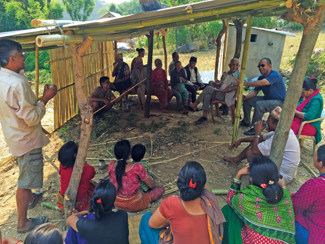
Ajay Sitaula (blue shirt, at right) talks with residents of Panthali, the village where Sitaula grew up, to find out what they needed. Residents told him they had food, water and emergency supplies; what they needed were supplies — especially tin roofing — to rebuild permanent houses. Credit: Ajay Sitaula.
NSET has also been involved with earthquake monitoring in Nepal. Hough met with NSET professionals in 2013 to train them in how to install low-cost accelerometers, which also function as seismometers. “You can plug these into almost any computer, and you have an earthquake monitoring instrument for $50 as opposed to $5,000,” Hough says. The project had barely begun before the Gorkha quake hit, but some sensors had been installed, and they recorded the first few seconds of the mainshock before power outages knocked them out. They came back online soon though, and recorded shaking from aftershocks. “This helps NSET and others see where aftershocks were located, and see how the shocks damaged specific areas,” Hough says. Such data helps inform changes in building codes.
The quake and its aftermath are still relatively recent events, and, according to Hough, the path forward for now includes “just making sense of the data and characterizing what happened.” A lot of useful data on the Gorkha quake were recorded by sensors operated by India and China, which are not yet making the data freely available, Hough notes. “That is not serving anyone’s interests.” Having access to as much data as possible will help with, for instance, microzonation efforts in Nepal, which involve characterizing the type and magnitude of seismic hazards — like liquefaction or landslide potential — likely to impact different parts of the country.
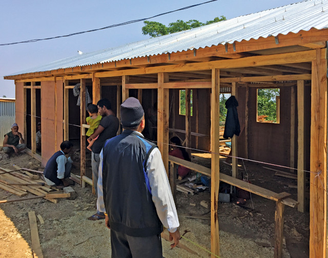
With the help of friends, Ajay, his wife Beth, and their families brought tin roofing to dozens of families. This was a new single story house under construction using light and strong materials. Houses like this one are a new concept to the villages, but people have realized that brick and clay houses are not reliable during earthquakes. Credit: Ajay Sitaula.
As rebuilding efforts continue in Nepal, Erdmann now says what struck him most is the resilience and reverence of the Nepalese people: Even through all of the devastation and turmoil, the people he and his fellow mountaineers visited didn’t lose their humanity.
“You go into devastated areas,” Erdmann says, “and the people still face you, press their hands together in prayer, bow, and say ‘namaste,’ which means both ‘hello’ as well as ‘I recognize the god in you.'”
© 2008-2021. All rights reserved. Any copying, redistribution or retransmission of any of the contents of this service without the expressed written permission of the American Geosciences Institute is expressly prohibited. Click here for all copyright requests.