
by Steven Newton Monday, May 9, 2016
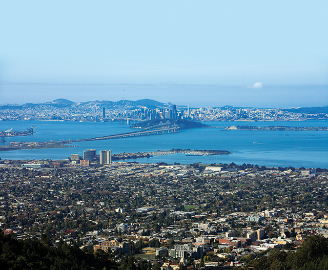
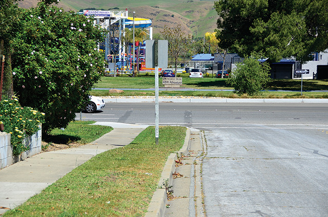
The entire length of the Hayward Fault runs through densely populated cities such as Oakland, Fremont and Berkeley (shown here), and is not far from the metropolises of San Francisco (background) and San Jose. The U.S. Geological Survey describes the Hayward Fault as "the single most urbanized earthquake fault in the United States." Credit: ©iStockphoto.com/ConstantGardner.
Last summer, a startling article appeared in The New Yorker magazine outlining what could happen to the Pacific Northwest in the event of a large earthquake resulting from a full rupture of the Cascadia Subduction Zone. As recently as 1700, this convergent zone produced an earthquake estimated at magnitude 9. If such an event happened today, the results would be devastating. The article attracted a great deal of attention, especially among people who had never heard of the possibility that the heavily populated Pacific Northwest could, in a geologic moment, become “toast” — as someone quoted in the article put it.
The Pacific Northwest is not the only region of the United States in tectonic jeopardy. The San Francisco Bay Area also suffers from the unfortunate confluence of large populations and active faults. However, the nine counties of the Bay Area are home to dozens of major faults — the San Andreas, the Calaveras, the Concord-Green Valley, the San Gregorio, the Rodgers Creek and the Hayward, chief among them. These very active faults, which produce small quakes (mostly under magnitude 2.5) on a daily basis as well as occasional quake swarms — a swarm in October 2015 produced more than 400 small quakes in two weeks — cut through important infrastructure in every city in the region, potentially affecting more than 7 million people.
Most people have heard of the San Andreas, which they assume will be the source of the next big quake in the Bay Area, thanks in part to Hollywood disaster movies, such as the dreadful “San Andreas,” which perpetuate geologic absurdities. Despite the notoriety of the San Andreas Fault, it is not the greatest seismic threat to the Bay Area. East of San Francisco, across the muddy, green waters of San Francisco Bay, sits a smaller fracture in the crust: the Hayward Fault. One day, the Hayward Fault could produce the greatest natural disaster ever to hit the United States.
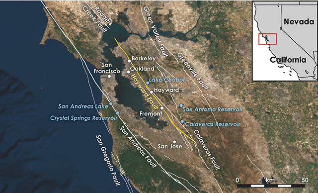
The San Francisco Bay Area is riddled with faults. One of the most dangerous is the Hayward Fault, which connects to the Rodgers Creek Fault to the north and seems to connect to the Calaveras Fault in the south, according to recent research. The Hetch Hetchy water system, which provides water to San Francisco, is extraordinarily vulnerable to seismic disruption as it moves water across several faults. And several of the system's reservoirs (shown on the map) sit directly on or very close to faults. Credit: K. Cantner, AGI.
The Hayward Fault splinters from the Calaveras Fault, which itself is an offshoot of the San Andreas Fault, near Hollister, south of the Bay Area. All three faults are right-lateral strike-slip faults. The Hayward Fault is shorter than the San Andreas, running about 70 kilometers from Fremont to Point Pinole, and is therefore not expected to produce the magnitude-8-plus quakes we know the San Andreas can generate. But what the Hayward Fault lacks in potential magnitude, it makes up for with proximity to people, lying directly under structures where many people live and work: hospitals, schools, retirement homes, and house after house after house.
The San Andreas cuts predominantly through remote areas, whereas the entire length of the Hayward Fault runs through densely populated cities such as Oakland (pop. 406,000), Fremont (pop. 224,000) and Berkeley (pop. 116,000), and is not far from the metropolises of San Francisco (pop. 805,000) and San Jose (pop. 945,000). The U.S. Geological Survey (USGS) describes the Hayward Fault as “the single most urbanized earthquake fault in the United States.”
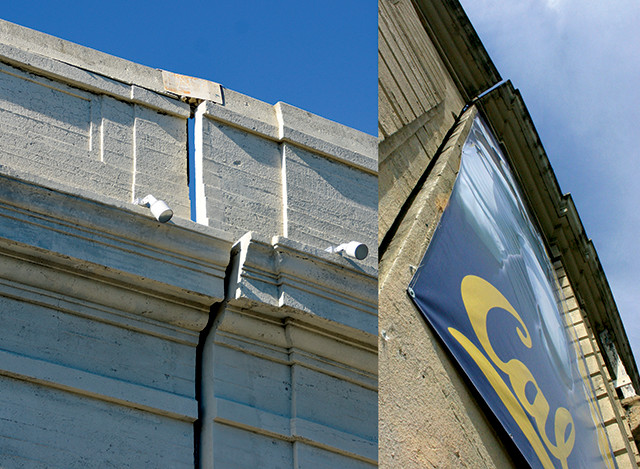
In Berkeley, the Hayward Fault runs beneath the University of California at Berkeley's football stadium, offsetting the south wall. Credit: top: Kai Schrieber, CC BY-SA 2.0; bottom: Steven Newton.
While some of the fault lies at a depth of 15 kilometers, near the Bay Area Rapid Transit (BART) commuter train station in Fremont, the fault breaches the surface. The surface expression can be seen near the Fremont Main Library and the Fremont Police Department, as well as two hospitals. It skirts the East Bay hills, then plunges into downtown Hayward, where it offsets the old Hayward City Hall, creating cracks in the walls and distinct offsets in the tile floor, and slices a retirement home. In San Leandro, the Hayward Fault runs near the Fairmont Hospital and the earthen dam holding back the Lake Chabot Reservoir. The entrance to the Oakland Zoo is marked by the fault; the zoo even notes the location of the fault on its grounds with a sign. In Berkeley, the fault runs beneath the University of California at Berkeley’s football stadium, where offset on the south wall can be seen. The fault continues north, underneath residential areas and the campus of Contra Costa Community College.
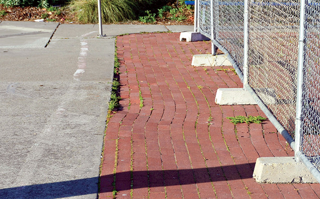
On the campus of Contra Costa Community College, the Hayward Fault distorts once-straight brick paving stones. Credit: Steven Newton.
When it ruptures, the Hayward Fault will do more than damage homes, zoos and football stadiums: It will endanger numerous lives and likely deal a devastating economic blow. According to the Bureau of Labor Statistics, the region is home to 87,000 businesses, 1.5 million jobs and quarterly wages nearing $25 billion; the Bay Area’s overall GDP would, if it were a separate country, rank as the 19th largest in the world.
Some of the most important American technology companies are located near the Hayward Fault. The headquarters of Facebook and Google and Apple’s new “spaceship” campus are less than 20 kilometers away — all close enough for shaking to affect the operations of the companies.
Given the Hayward’s proximity to large populations, its rupture presents a huge risk. But when might that risk become reality? The last significant quake on the Hayward Fault was in October 1868. That quake is estimated to have been about magnitude 6.8. James Lienkaemper of the USGS has done pioneering work both in mapping the location of the Hayward Fault and in estimating the long-term frequency of its major tremors. In a 2012 paper in the Bulletin of the Seismological Society of America, Lienkaemper and colleagues determined that the fault’s recurrence interval over the last two millennia is about 161 years, plus or minus 65 years. The last quake was 148 years ago, so we currently sit within that range.
In 2015, the Working Group on California Earthquake Probabilities released the third Uniform California Earthquake Rupture Forecast, which increased the probability of a major quake (magnitude 6.7 or above) in the San Francisco Bay region to 72 percent within the next 30 years. Of the many faults in the Bay Area, the Hayward Fault has the greatest likelihood of producing such an event.
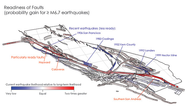
This map from the third Uniform California Earthquake Rupture Forecast indicates which California faults are most "ready" or at risk of rupture, based on stress buildup. The Hayward is one of the highest risk. Credit: U.S. Geological Survey.
The Hayward Fault is unusual in that, in addition to rupturing every so often, it experiences aseismic creep; in other words, the fault slips, releasing stress gradually without necessarily producing earthquakes. Aseismic creep is rare throughout the world, although it occurs on the San Andreas, the Calaveras and the Hayward faults. However, the accumulated creep on these faults does not match estimates of stress expected to have accumulated on them, as Sarah Titus, now at Carleton College, and her colleagues demonstrated in a 2005 paper in Geology. This “slip deficit” suggests that creep will not prevent future quakes, according to Kristy Tiampo, now at the University of Colorado at Boulder, and her colleagues, who explored the issue in a 2013 study in Earth and Planetary Science Letters. But creep on the Hayward Fault does allow us to map its trace precisely, and to see where large ruptures might happen when the fault does break again.
When the last quake struck the Hayward Fault in 1868, the Bay Area was sparsely populated. The town of Hayward had about 500 residents, and just 24,000 people lived in the East Bay in the immediate vicinity of the fault. Thirty people in the region were killed by the quake while nearly every building in Hayward was damaged or destroyed. Today, Hayward has about 149,000 people, and 2.6 million people live in the immediate vicinity of the fault. What would a big quake on the Hayward Fault do?
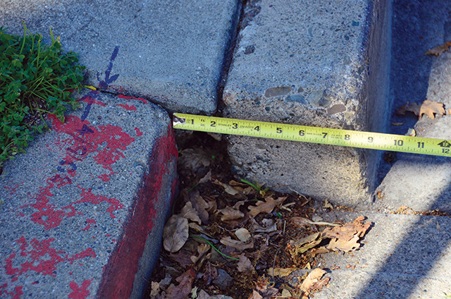
One of the southernmost exposures of the Hayward Fault is near the intersection of Gardenia Way and South Grimmer Blvd. in Fremont. Here, cracking of the street is very pronounced, although this spot has since been repaved. This site is near Arroyo Agua Caliente Park, a name that suggests a hot spring — always a good indicator of fault activity. Credit: Steven Newton.
One way to assess this question is to compare a potential large Hayward quake to events of similar size in areas of similar population. The 1995 Kobe quake, a magnitude-6.9 event in southern Japan, has been proposed as the best analogue for a future Hayward earthquake, which is expected to have a similar magnitude and may have a similar rupture length. The length of rupture in Kobe was similar to that of the 1868 Hayward quake. The Kobe quake also caused 1.5 meters of horizontal displacement on the ground; given the energy accumulated since the 1868 quake and the displacement observed in that event, scientists expect about 2 meters of horizontal displacement on the Hayward Fault, according to a 2008 fact sheet from USGS. The idea of a Kobe-type quake occurring on the Hayward is unsettling: Out of a population of 1.5 million in Kobe, nearly 5,000 people were killed.
Another way to assess the Hayward Fault’s potential damage is through FEMA’s hazard modeling program, HAZUS, which allows users to select variables such as the location of an earthquake’s epicenter, the length of a rupture, the magnitude and depth of a quake, and the time of day when it occurs.
I recently ran a HAZUS model for a Hayward Fault rupture. I set up the model runs under three scenarios with varying event magnitudes: low (magnitude 6.7), moderate (7), and major (7.2). Sufficient stress for a magnitude-6.7 quake is thought to have already accumulated, but recent research suggests even larger quakes are possible; in a 2015 paper in Geophysical Research Letters, Estelle Chaussard of the University at Buffalo and her colleagues suggested the Hayward and Calaveras faults are deeply connected, and thus a rupture could propagate along the two faults and produce quakes greater than magnitude 7. For my model runs, I chose an arbitrary epicenter near the Lake Chabot Reservoir dam (which is one of many reservoirs located near the fault that could inundate neighborhoods if the dams fail).
This is the range of buildings damaged modeled by HAZUS for the three different magnitude scenarios:
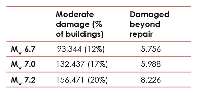
Table showing the range of buildings damaged as modeled by HAZUS for three different magnitude scenarios. Credit: Steven Newton.
Assessing casualties is more challenging. For instance, a lot depends on where people are when the quake hits. At 2 a.m., most people would be home asleep in wood-framed, single-family homes that are unlikely to collapse completely. But if a quake occurred at 2 p.m. on a weekday, many people would be at work or school in vulnerable structures constructed with brick walls and unreinforced masonry. The HAZUS model estimates the death toll of a 2 p.m. quake would be five times greater than a quake occurring at 2 a.m. (The Kobe quake occurred before 6 a.m., as did the 1994 Northridge quake and the 1906 San Francisco quake. It is possible that each of these quakes could have produced higher casualties if they had occurred later in the day.)
HAZUS predicts casualties in these ranges:
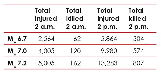
Table showing HAZUS predictions of casualties for three different magnitude scenarios. Credit: Steven Newton.
Clearly, there is a big difference in the number of deaths predicted by the HAZUS model for this potential Hayward earthquake and the experience in Kobe, with HAZUS estimating an order of magnitude fewer. We can only hope that the computer model proves the better predictor.
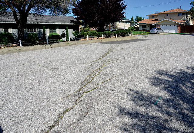
Rockett Drive in Fremont shows the distinctive evidence of fault creep. As with all offsets on the Hayward, the sense of movement is right-lateral; in other words, when looking across the fault, the other side appears to be moving to one's right. Credit: Steven Newton.
HAZUS can also model how infrastructure other than buildings will be affected by a quake. For instance, it suggests that immediately after a magnitude-7 Hayward Fault event, out of 920,502 households near the fault trace, 298,605 (32 percent) will be without water and 367,519 (40 percent) will be without electricity. These losses are just the beginning of the infrastructure problems a Hayward Fault quake will create. A big quake in a highly populated area means that virtually every aspect of modern civilization — transportation, gas, sewer, water, electricity, Internet access and more — will be affected.
Transportation problems will be felt immediately after the quake. More than 400,000 commuters use the BART system on weekdays. BART has made efforts to retrofit its infrastructure, but a 2002 study estimated that major damage from an earthquake to the underwater trans-bay tunnel, through which the rail line travels, could shut down the BART system for two to three years, with disastrous effects on the local economy. A 2010 report by the Earthquake Engineering Research Institute noted the 2 meters of expected offset in the BART Berkeley Hills Tunnel, versus the 0.6 meters of displacement it was engineered to accommodate, could “put the tunnel out of commission indefinitely.”
Traveling over the water will be no less difficult; HAZUS estimates between 43 and 78 bridges will be damaged. Since many of these bridges form choke-points in traffic flow, damage to even a few could create epic traffic jams. However, such traffic jams may never materialize if damage to road infrastructure is so severe that people cannot get on the freeways at all.
Long stretches of freeways in the Bay Area sit near sea level, built on marshy tidal flats that will almost certainly experience liquefaction during the quake. If liquefaction damages even small sections of such freeways, they become unusable. Additionally, if freeway overpasses collapse or become too damaged for vehicles to travel underneath them safely, then freeways are rendered useless. In many parts of the Bay Area, these roadways represent the only feasible way to move between areas; freeways physically isolate some communities, with pedestrian movement impossible between them. The quake would essentially cut off large parts of the Bay Area.
Ground movement also has the potential to destroy water delivery systems at multiple levels: at the household level, with pipes breaking and flooding homes or unsecured water heaters detaching; at the neighborhood level, with breaks in municipal water lines or water mains; and at the city level, with municipal water treatment plants failing or reservoirs and dams rupturing. Repairs for many of these problems, which involve digging up streets and rebuilding major parts of the water infrastructure, would take months to years. While hazard planners commonly advise Bay Area residents to stockpile enough water for 72 hours, the reality is that many areas will be cut off from water infrastructure for far longer.
A further problem is flooding. Most of the Bay Area’s water is impounded in reservoirs, in hills far out of sight and out of mind of the residents. Each reservoir has the potential for damage and catastrophic failure. The worst flooding could happen to the city of Fremont. The Calaveras and San Antonio reservoirs store more than 180 million cubic meters of water, perched above the city of Fremont and its 224,000 residents. These reservoirs sit 8 and 11 kilometers, respectively, from traces of the Hayward Fault as it passes through Fremont.
The worst-case scenario is a rupture of one or both of these reservoirs. Inundation maps based on ruptures from these reservoirs show the entire city of Fremont flooded, from the hills to the bay. Underscoring this risk, the Calaveras Reservoir’s earthen dam, constructed in 1925, has been deemed so seismically vulnerable that a replacement dam farther downstream is currently under construction.
The Calaveras and San Antonio reservoirs are part of the Hetch Hetchy water system, an improbable Rube Goldberg-like scheme to move water from the Sierra Nevada across the Central Valley, across the Calaveras Fault, across the Hayward Fault, across the liquefaction-vulnerable marshes of the southern bay, then into two long, linear sag ponds: the Crystal Springs and San Andreas reservoirs. (The latter gave its name to the fault when it was first recognized in 1895.) The Hetch Hetchy water system is extraordinarily vulnerable to seismic disruption. Unfortunately, it is also the prime water source for San Francisco.
The Hayward Fault holds the potential for great devastation, but many people are only vaguely aware of the danger it poses. In my nearly two decades of teaching geology in the Bay Area, I have found that surprisingly few people even know where the fault is. But all they have to do is look. There are dozens of places where streets and parking lots are cracked, where sidewalks are dramatically offset by creep along the fault, and where cracks have appeared in buildings, such as the concrete wall of a playground near the Hayward Plunge swimming center. These cracks are the harbingers of the major seismic disaster that will one day affect millions of people in the region.
The science is clear: We know where the Hayward Fault is and we know it is going to rupture in the future. When it will happen is unknown, but the effects of such an event are quite clear: Major shaking to fragile infrastructure will result in loss of life and great economic damage. The scientific community has mapped the fault and assessed the risk. Scientists have done their jobs.
overnments, however, have not done theirs. Not only are homebuyers not protected by any required disclosures in contracts, but there has also been a failure to prepare for the inevitability of this quake. How will hundreds of thousands of newly homeless people in the region survive absent running water, absent sewage systems, and absent electricity?
Local governments could have helped this situation by restricting development in areas near the fault. They can still remedy the mistakes of the past, however, in part by offering buyouts as an incentive to move people away from the worst zones. Instead, the opposite is happening, and across the Bay Area, new homes are being built in fault zones with seemingly no consideration for what could happen to the people in them.
One of the most well-documented offsets along the Hayward Fault is at the intersection of Rose and Prospect Streets in Hayward. Here, decades of changes to a single curb have been photographed by Sue Hirschfeld, professor emeritus at Cal State University Hayward (East Bay). Her photographs show this intersection as early as 1971, when offset was minimal. Decade by decade, the fault has shifted — as have the foundations of nearby homes. In fact, many homes in the vicinity of this intersection show visible distress, such as cracks radiating from windows and garage doors that close unevenly, because of fault movement. Credit: Steven Newton.
Building codes could be strengthened to require retrofitting of weak, soft-first-story buildings and to require demolition of dangerous brick buildings that cannot be retrofitted. Household gas meters could be required to have motion-activated automatic shut-off switches, a technology widely used in Japan to reduce post-quake fire danger. Local governments could establish community caches of critical supplies — drinking water, food, medicine and tents, for example — in areas likely to be devastated by the shaking. Unfortunately, for the most part, such prudent preparations are not being made.
We have no excuse not to prepare for the coming quake. Just as the citizens of the Pacific Northwest may one day find themselves affected by the Cascadia Subduction Zone, the Bay Area will be damaged by the Hayward Fault. It’s just a matter of time before a large earthquake on the Hayward Fault happens, but how we choose to prepare — or not to prepare — will make a tremendous difference to those caught in the aftermath of this inevitable disaster.
© 2008-2021. All rights reserved. Any copying, redistribution or retransmission of any of the contents of this service without the expressed written permission of the American Geosciences Institute is expressly prohibited. Click here for all copyright requests.