
by Mary Caperton Morton Wednesday, April 25, 2012
Mobile lidar mapping unit. Courtesy of ELMF
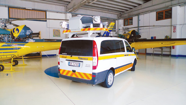
Traditional lidar data are collected from airplanes or satellites. Mobile mapping using lidar can now be done from a car. Courtesy of WHPacific
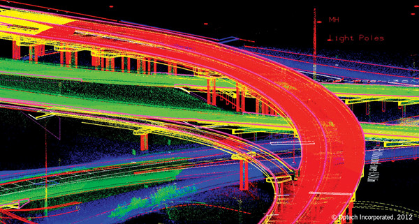
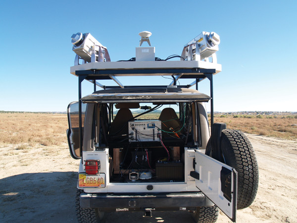
Mobile mapping can be used in large cities to map everything from power lines to high-rise buildings to highways. Courtesy of Optech
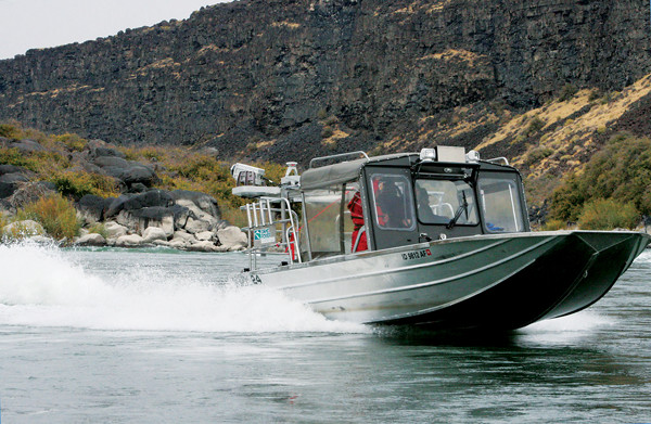
Mobile mapping can also be done from a boat, such as while motoring down the Snake River in Hells Canyon along the border of Oregon and Idaho, as seen here. WHPacific mapped the waterway for Idaho Power for hydroelectric and water management purposes. Courtesy of WHPacific
About a decade ago, Light Detection and Ranging technology, also known as lidar, burst onto the geoscience scene. The tool was quickly adopted by researchers, from archaeologists and geomorphologists to seismologists and atmospheric scientists.
By mounting lasers and detection and positioning instruments on an airplane or satellite, researchers could map everything from Mayan ruins lost beneath thick jungle canopies to erosion along shorelines to the structure of particulate plumes emitted from power plants to the topography of entire countries.
Now, a new generation of lidar technology is bringing the laser-based survey method down to Earth by mounting the instruments atop SUVs, boats and even backpacks. When these mobile mapping systems become more readily available, they’ll give geoscientists a whole new way to map and study the world.
Lidar systems consist of four different instruments: a laser, a scanner, a photodetector and a positioning system. These integrate to measure the distance to an object by illuminating the target with pulses of light from the laser and measuring the time it takes for each pulse to bounce back to a sensor. Because light moves at a constant and known speed, the distance between the instrument and an object can be measured with a high degree of accuracy. A rapidly firing laser can cover entire landscapes in a few sweeps, “painting” the topography and extracting data. Computer software then transforms raw numbers into colorful 3-D point clouds, and the end products are multilayered, high-resolution maps.
Usually, lidar is mounted on planes or satellites that look down on the ground from above. In fact, “nearly all lidar mapping studies so far have been done from airplanes,” says Chris Crosby, manager of the Open Topography project at the San Diego Supercomputer Center in California, which collates the massive datasets produced by lidar-based survey studies. That’s where things are changing.
Last November, nearly 500 exhibitors and delegates from 14 different countries gathered in Salzburg, Austria, for the second annual European Lidar Mapping Forum, a companion conference to the larger International Lidar Mapping Forum, whose 12th annual meeting was held in Denver, Colo., in January 2012. “One of the main goals of the forums is to make lidar understandable, easy to use and accessible,” says Alastair MacDonald, chair of the European forum, based in Gloucestershire, England.
Even with two conferences a year, there’s never a shortage of new information to be presented, MacDonald says. “New developments from the technology manufacturers and software specialists are appearing at ever-increasing speed, constantly opening new doors and creating new applications for lidar mapping.”
One of the main focuses of this year’s forums was mobile mapping technology, which mounts lidar instruments on top of a car or truck. The instruments then collect mapping data while being driven at normal highway speeds.
“Lidar technology is made for mobile mapping because these systems can maintain high accuracy and high resolution from rapidly moving platforms,” says Ian Rayns, street mapping project manager for 3-D Laser Mapping, an engineering firm based in Nottingham, England, and an exhibitor at both the European and International forums.
When a mobile mapping-equipped vehicle is driven down the road, even at speeds of 100 kilometers per hour, the rooftop-mounted laser scanners spin at a rate of 100 rotations per second, picking up 300,000 reference points a second, Rayns says.
So far, these mobile mapping setups, equipped with multiple lasers and scanners and 360-degree imaging cameras, have mainly been used for highway surveys and roadside inventory projects — important steps in roadway construction and maintenance.
Mobile mapping is much more cost-effective than other highway survey methods, Rayns says. Jobs that normally take months to survey can be done in one day, in one trip down the road. Mobile mapping is also much safer than traditional survey methods, which can put workers in harm’s way, he says. “Mobile mapping is really revolutionizing how we approach surveying.”
There’s no reason geologists couldn’t use the same technology to survey along roads, Rayns says. And on occasion, surveys have crossed into the realm of the geosciences with interesting results, he says. For example, in March 2011, after the massive Tohoku earthquake devastated Japan, vehicle-mounted lidar systems provided by 3-D Laser Mapping were used to assess damages to roads and buildings, information that aided in planning evacuations and disaster relief.
Another division of 3-D Laser Mapping works exclusively with developing survey products for use in mines. “Mining companies use lidar not so much for exploration purposes, but more often for safety and monitoring,” says Chris Wood, project manager for mining at 3-D Laser Mapping. For example, lidar scanners are used in open pit mines to monitor small-scale failures that might lead to catastrophic failures and collapses. Scanners are also used to monitor stockpiles and measure how much material has come out of a mine and whether the debris piles are getting dangerously steep.
“So far, most of the mining lidar is done stationary, mounted on a pillar and aimed at a spot 24 hours a day to monitor changes, but that’s evolving,” Wood says. “In the next few years, I think we’ll see mobile technology catch on in the mining world. In fact, we just supplied a mobile system mounted to a pickup truck to a South African gold mining [company].”
Wood says the main obstacle will be to prove mobile lidar’s durability in typically harsh mining environments, but he is confident the instruments will pass the test and perhaps lead to more diversified applications in the mining sector. “Mining companies are not short on money, so if anybody’s going to start [using lidar], it’ll be them.”
“Mobile mapping platforms are really hot in the commercial sector,” Crosby says. But, he says, mobile mapping hasn’t caught on much with the academic community — yet.
The idea of producing finely detailed geologic maps just by cruising down the road is enough to start most geoscientists scheming. “How about putting a unit on a four-wheel-drive and driving down a beach a few times a year to track erosion and sand migration? Or I can imagine mounting one of these units on a train that’s crossing the West or on a boat to study how rivers meander and change over a season,” Crosby says. Still, he says, “as exciting as the prospects are, I have yet to see a geoscience dataset that has been collected by mobile mapping.”
“As always, it comes down to money,” says Jay Parrish, a geophysicist at Penn State University who has used airplane-mounted lidar to map all of Pennsylvania as part of the U.S. National Map project, organized by the U.S. Geological Survey. “We looked into mobile mapping when we were working on the PA Map project, but while it was easy to rent an airplane, it was impossible to find a car [equipped with lidar].”
But that may soon change. Airborne lidar surveys dropped steeply in price in 2008, when multiple companies started offering air surveying at competitive prices. The same “for hire” system could work for mobile mapping too, Parrish says, but so far companies offering that service are few and far between.
“I think it’ll happen,” he says. “As with any technology, the first few years it’s hard to find and expensive, but then you pass a certain threshold and it becomes more widely available.”
One of the other major hurdles to more widespread mobile mapping is data handling: Mobile mapping can produce hundreds of terabytes worth of data, whereas airborne mapping surveys are usually on the order of hundreds of gigabytes, a thousand-fold difference.
The difference lies in both resolution — most airborne scans have a resolution of a half-meter, whereas terrestrial scans are on the order of centimeters — and perspective, producing high-res, truly 3-D datasets, Crosby says.
“Mobile mapping will be challenging for us in the data and distribution field because it generates a lot of data,” he says. “How we process and analyze the data will become a lot more complex.”
Mobile mapping at the ground level is also a much harder geolocation problem than taking airborne data, where onboard positioning systems have an unobstructed view of global positioning satellites, Crosby says.
“There’s no point in having a really great scanner if you don’t know where you’re pointing it,” Rayns notes. “That’s really the next step in mobile mapping technology: addressing the GPS blackouts that can occur in high-rise cities and in some remote parts of the world.”
When it comes to the geosciences, lidar-based mobile mapping technology has a lot to offer: fast, accurate, high-resolution mapping, all from the convenience of a car. Now, geoscientists just need affordable access.
Some companies like WHPacific, an engineering firm based in Albuquerque, N.M., are working on that. In 2008, WHPacific acquired a LYNX Mobile Mapper from Optech, a hardware company based in Toronto, Canada.
“The LYNX is high-tech, but, as a research tool, it’s not necessarily high cost,” says Clay Wygant, WHPacific’s mobile lidar specialist. “This system has a very small footprint: There’s no plane, no jet fuel. It’s just a vehicle and two people.”
WHPacific has used its mobile unit to produce maps for a wide variety of projects all over the western United States, including scanning landscapes to create sets for a computer-generated-imagery dinosaur movie, conducting highway surveys for the Bureau of Indian Affairs in New Mexico and studying alluvial fans along the Snake River in Hells Canyon for Idaho Power.
“We’re definitely eager to work on more geoscience-related projects,” Wygant says. “It seems half the battle is getting the word out that this technology is available and affordable. We’re willing to tackle any project. The applications are endless and as far as we’re concerned, the sky’s the limit.”
© 2008-2021. All rights reserved. Any copying, redistribution or retransmission of any of the contents of this service without the expressed written permission of the American Geosciences Institute is expressly prohibited. Click here for all copyright requests.