
by David B. Williams Thursday, January 5, 2012
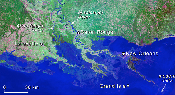
What researchers predict the delta may look like in 2100. Courtesy of M. Blum, original image from NASA's GeoCover Data
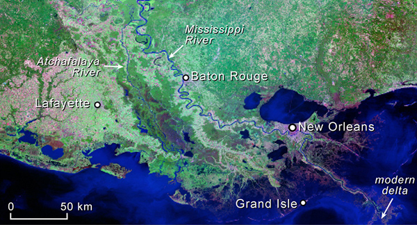
Mississippi River Delta in 2000. Courtesy of M. Blum, original image from NASA's GeoCover Data
The Mississippi River Delta is arguably the most geologically (and politically) dynamic delta in the United States. Subsidence, sedimentation, sea-level change and human manipulation constantly alter the landscape at the end of North America’s longest river. But now, researchers say, the beloved delta may be irrevocably shrinking.
Scientists have studied nearly every aspect of this delta for decades, but no one had quantified how much sediment pours into the delta — one of the most essential dynamics of the ecosystem — until now. Mike Blum and Harry Roberts, geologists at Louisiana State University in Baton Rouge, measured the amount of sediment entering the delta and came to one conclusion: No matter the scenario, not enough sediment flows down the Mississippi and into the delta to prevent much of it from slowly disappearing into the Gulf of Mexico.
“It was a hard decision to write this,” Blum says. “Some people have objected.” Those objections come not because of how the scientists obtained their data, but because of their dire conclusions, he says. “It’s sad really that there may not be much that can be done with such a historic area with so much economic and social significance. Many people may have to move.”
The modern Mississippi Delta began to take shape about 6,000 to 7,000 years ago when sea-level rise stabilized after the last glacial maximum. New subdeltas have been forming every 1,000 to 1,500 years, giving the overall delta its classic bird-foot shape. Blum and Roberts combined GIS measurements of the delta’s expanse with measurements of the thickness of post-glacial sediment deposits to determine that between 2.79 trillion and 3.45 trillion tons of sediment have been stored in the delta since the end of the last glacial maximum, they reported in Nature Geoscience. This equals roughly 1,860 to 2,300 cubic kilometers of sand and silt, or enough material to form 780,000 Giza pyramids.
The devastating flood of 1927 led to a drastic change in river dynamics, as people constructed upstream dams and thousands of kilometers of levees along the river. The most important consequence was the loss of sediment downstream. Before the dams, the Mississippi carried 400 million to 500 million tons of suspended sediments annually. Today, the researchers say, the average suspended sediment load is about 205 million tons per year, which is significantly less than it took to construct the delta in the first place.
Sea-level rise further exacerbates the problem of the delta’s dwindling sediment load. During the period of delta development, sea levels rose less than 1 millimeter per year. But the observed data and predictions from the Intergovernmental Panel on Climate Change show sea-level rise is now at 3 millimeters per year and may accelerate to 4 millimeters or more per year in 2100. Blum and Roberts reported that this change, plus the effects of subsidence, will submerge up to 13,500 square kilometers by 2100. This compares with a 5,700-kilometer loss in previous estimates by the U.S. Geological Survey of total land loss from the early 1950s to 2050.
“The questions then are whether we could increase the sediment load and how many diversions would we need to replenish the system,” Blum says. To answer these questions, Blum and Roberts considered four scenarios of how sea-level rise and sediment load might change in the future. They found that the only way to maintain the modern landscape is if the Mississippi River’s sediment load returned to its pre-dam level and if annual sea-level rise dropped back to 1 millimeter per year — an impossible scenario to achieve, even with river restoration, they wrote, adding that further land loss is inevitable.
“People should really take notice of this study. This is very overdue,” says Torbjörn Törnqvist, a geologist at Tulane University in New Orleans, La. “It’s a solid analysis. If you want to criticize their data, it would be that it’s too conservative. There is no way the present entire coast will exist as it is. People will have to make difficult decisions.”
Blum, however, offers a slight glimmer of hope. “Slow changes creep up on people and they don’t realize it and don’t think about it,” he says. “Perhaps this might force people to [think] about what is facing them.” No matter what we do — whether we build new and more efficient diversions throughout the river system or remove upriver dams to allow more sediment back into the system — Blum concludes that we are going to have to think carefully and move fast. “Every decade of delay,” the authors wrote, “will increase the mass balance deficiency by more than a billion tons of sediment.”
© 2008-2021. All rights reserved. Any copying, redistribution or retransmission of any of the contents of this service without the expressed written permission of the American Geosciences Institute is expressly prohibited. Click here for all copyright requests.