
by Mary Caperton Morton Wednesday, January 16, 2019
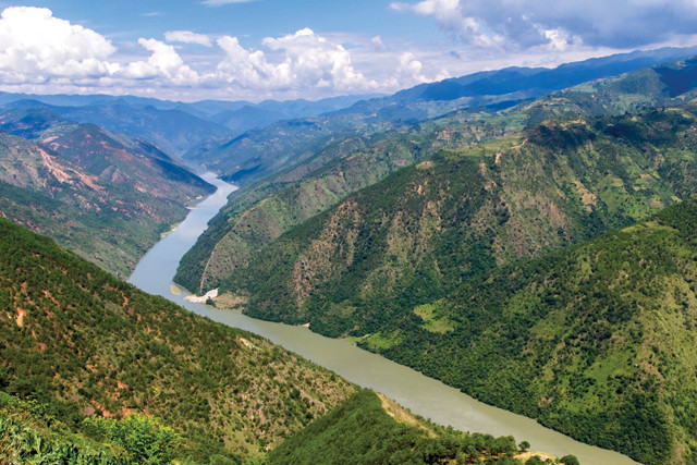
The Mekong River is the longest river system in Southeast Asia, flowing through six countries. Here, the river flows through Yunnan province in China, where it's known as the Lancang River. Credit: shutterstock.com/HelloRF Zcool.
The rivers draining the Tibetan Plateau are some of the largest, longest and most deeply incised waterways in the world. For decades, most geologists assumed that these river canyons were cut as the plateau was uplifted following the initial collision of the Indian subcontinent with Asia. However, recent studies have found that the plateau was already elevated by 40 million years ago — roughly 20 million years before the deep canyons formed. In a new study, researchers have identified a different force driving the Mekong’s incision: intensification of the Asian monsoon starting about 17 million years ago.
The Mekong River originates on the Tibetan Plateau and is the longest river system in Southeast Asia, flowing through China, Myanmar, Laos, Thailand, Cambodia and Vietnam. In some places, the canyon cut by the river is 1 to 2 kilometers deep. But despite its impressive stature, “historically, most of the research and attention [in the region] has gone to the Yangtze River,” says Gregory Hoke, a geomorphologist at Syracuse University in New York and a co-author of the new study in Nature Geoscience.
In the 2000s, the leading hypothesis for the formation of the Mekong River canyon paralleled the prevailing explanation for the Yangtze River: As the Tibetan Plateau rose, the rivers incised the landscape, cutting the deeply entrenched canyon seen today. Thermochronology studies found that most of this incision took place between 15 million and 12 million years ago. But in 2014, Hoke and his colleagues published research in Earth and Planetary Science Letters in which they used stable isotopes to show that uplift of the Tibetan Plateau had already taken place during the Paleocene about 40 million years ago, a finding since corroborated by several independent studies. “If the Tibetan Plateau was already at modern elevations in the Paleocene, it makes it difficult to claim that tectonics were driving river incision some 20 million years later,” Hoke says.
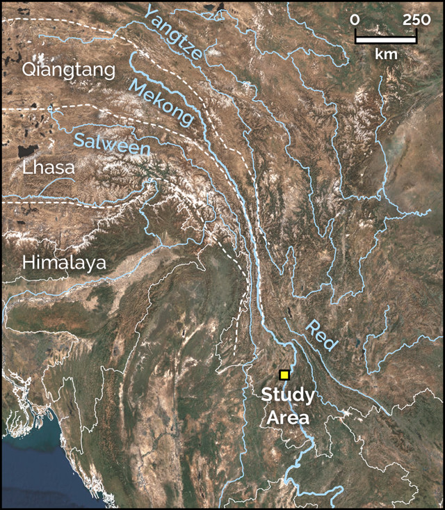
The rivers draining the Tibetan Plateau are some of the largest, longest and most deeply incised waterways in the world. Credit: K. Cantner, AGI, after Nie et al., 2018.
Instead, Hoke and his colleagues propose that the incision of the Mekong can be chalked up to a surge in the monsoon cycle starting roughly 17 million years ago, during the middle Miocene. This timing is supported by thermochronologic analyses of apatite mineral crystals collected throughout the lower Mekong River. Based on numerical models, the researchers also showed how the stronger monsoon could drive the degree of downcutting needed to form the Mekong’s canyon in just a few million years. “This solves the problem of how river incision took place in the absence of tectonic uplift of the Tibetan Plateau,” Hoke says: “The monsoon did all the work.”
“This climate versus tectonics debate has been going on for decades, and I don’t expect any one study to resolve it once and for all. It’s unusual that this paper takes such a hard climate line as tectonics is often thought to be the dominant driving factor [in geomorphology],” says Marissa Tremblay, a geochemist at the University of Glasgow in Scotland, who was not involved in the new study. “I think this study will be provocative and will inspire more research in this area.”
Hoke says the next step is applying the findings to other rivers in the region, including the Red, Salween and Yangtze rivers. “In the northern Yunnan province [in China], the Salween, Yangtze and Mekong rivers are each separated by one mountain ridge,” Hoke says. “One could argue that if the monsoon was driving the incision of the Mekong, it probably also had an important a role in the adjacent rivers as well.”
Tremblay agrees. “The general consensus in the community is that the Mekong, Salween and Yangtze are linked,” she says. “If there is a strong climate signal on one river it should appear in the others in the region because they are so closely related.”
© 2008-2021. All rights reserved. Any copying, redistribution or retransmission of any of the contents of this service without the expressed written permission of the American Geosciences Institute is expressly prohibited. Click here for all copyright requests.