
by Mary Caperton Morton Thursday, December 17, 2015
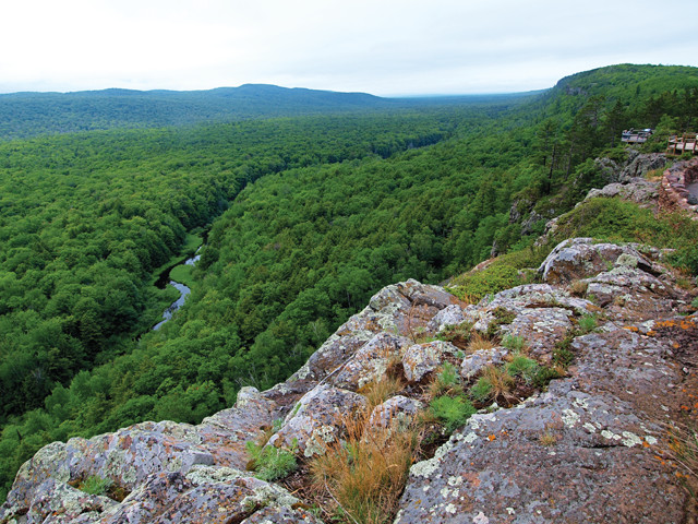
Many of the rocks exposed around Lake Superior were uplifted from the Midcontinent Rift during the formation of Rodinia, including these basalt cliffs along the Porcupine Escarpment in Michigan's Upper Peninsula. Credit: Mary Caperton Morton.
Middle America is not often recognized for its interesting geology, yet it boasts one of the largest and most unusual geologic features in the country: the Midcontinent Rift, which stretches 3,200 kilometers in two arms from Lake Superior to Oklahoma and Alabama. Subsurface imaging of the rift has revealed that it’s not just a rift, it’s also what’s known as a large igneous province, making it a hybrid geologic feature not seen anywhere else in the world. A new modeling study is offering a more complete story of how the Midcontinent Rift evolved, in three stages.
“The Midcontinent Rift is a very strange beast,” said Carol Stein, a geologist at the University of Illinois at Chicago and lead investigator of the new study, published in Geosphere, in a statement released last year when Stein and her colleagues presented research on the rift at the annual meeting of the Geological Society of America. “Rifts are long, narrow cracks splitting Earth’s crust, with some volcanic rocks in them that rise to fill the cracks. Large igneous provinces, or LIPs, are huge pools of volcanic rocks poured out at Earth’s surface. The Midcontinent Rift is both of these,” she said.
The Midcontinent Rift is about 1.1 billion years old, dating to the Proterozoic when North America existed as part of the ancient continent Laurentia, but the timing and stages of the rift’s formation have long been something of a mystery. “If you read the basic geology descriptions of the Midwest, there’s not much information in the literature about the rift,” Stein told EARTH. “We still have a lot of unanswered questions about how this feature formed.”
To investigate the evolution of the rift, Stein and her colleagues turned to data from EarthScope, a long-term National Science Foundation-funded project that uses geophysical and geological methods to map the underlying structure of North America. They plugged the EarthScope data into a reverse modeling software program that reconstructs geologic processes by going from the present day backward through time. Modeling the evolution of both arms of the rift, which meet in the Lake Superior region and extend southwestward to Oklahoma and southeastward to Alabama, the team identified three distinct phases of formation: rifting, sedimentation and uplift.
According to Stein and her colleagues, the Midcontinent Rift began as a traditional continental rift, similar to the East African Rift today, where extensional forces pull tectonic plates apart. As the rift was still pulling apart, magma, possibly generated by a mantle plume deep under the Laurentian craton, began flowing into the developing crack from above — when surface lava flowed into the crack — and from below. “This was a huge amount of molten rock, like the Columbia River Basalts [in the Pacific Northwest] or the Deccan Traps [in India], but instead of spreading out on the surface, forming a thin layer a few kilometers thick, it all got trapped within the rift,” Stein says.
After about 10 million years, the rift stopped spreading, becoming what geologists call a failed rift, but the magma kept flowing for a few million years longer, eventually piling more than 20 kilometers thick in some places, Stein says. Rifts are not normally associated with flood basalts, and the Midcontinent Rift’s dense, magma-filled crack gives the feature a different appearance in geophysical imaging profiles compared to other continental rifts, which are usually filled with low-density sediments, she says.
The second phase of the rift’s evolution began when the magmatism stopped and sediments began filling the exposed crack, Stein says. The sedimentary layers that sit on top of the magma in the rift are between 5 and 8 kilometers thick and are not well dated, she notes. “We estimate that this period of rapid sediment accumulation probably lasted about 50 million years.”
The third phase consisted of a series of compressive events due to collisions between North America and other smaller landmasses that eventually formed the supercontinent Rodinia, although the timing of this stage is not well understood. This compression uplifted some of the rocks contained in the rift system, exposing them at Pictured Rocks National Lakeshore and other locations around Lake Superior.
This three-stage story of the rift is not entirely original, says Nicholas Swanson-Hysell, a geologist at the University of California at Berkeley who was not involved in the new study. But, he says, the reverse modeling software the team used presents the story in a more coherent form. “They’re taking ideas about the rift that have been out there for a while and presenting a very nice synthesis of it all,” he says.
“Getting a better idea of the timeline is important because that will allow us to really get at some of the nuances of the remaining questions about the rift’s formation,” Swanson-Hysell adds.
Stein says she and her colleagues plan to continue studying the rifting process, using both modeling and uranium-lead dating, to pin down a timeline for the sedimentation and uplift phases in particular. “Ultimately, we’d like to be able to describe the geology of the Lake Superior region, including the rift, for the general public who visit the many parks in this region,” Stein says. “It’s a beautiful area with a lot of fascinating geology.”
© 2008-2021. All rights reserved. Any copying, redistribution or retransmission of any of the contents of this service without the expressed written permission of the American Geosciences Institute is expressly prohibited. Click here for all copyright requests.