
by Lance Newman Tuesday, April 19, 2016
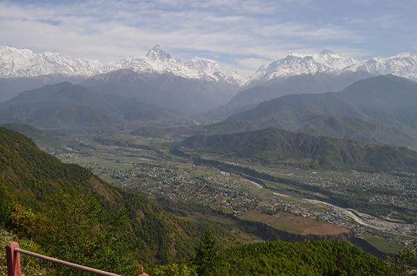
Scientists found that the sediments underlying Pokhara, in Nepal, which suffered substantial damage from the April 2015 Gorhka earthquake, were deposited by landslides triggered by several medieval-age earthquakes. Credit: Amelie Stolle
The magnitude-7.8 Gorkha earthquake in Nepal in April 2015 triggered landslides and damage that killed more than 8,500 people and injured at least 20,000, including many in and around Pokhara, the country’s second largest city. In a new study, scientists have found evidence that the city — also a major center of tourism in Nepal — and its surroundings sit atop debris from several large medieval-age quakes, confirming that the recent temblor is only the latest in a region with a long history of major earthquakes.
Prior to the 2015 quake, many scientists suspected that the region was due for a large event based on scattered evidence of earthquakes over the last millennium; but as with all earthquakes, no one knew for certain when it would occur. Archival records in Kathmandu hold some clues about past major earthquakes, but relying on these records alone might give biased results about the region’s seismic history because they tend to be restricted to densely populated areas, says Wolfgang Schwanghart, a geologist from the University of Potsdam in Germany and lead author of the study. They also “usually miss earthquakes that don’t reach the surface,” meaning events that don’t cause visible damage in populated areas tend to go unrecorded.
One of the main ways in which scientists develop and improve seismic hazard forecasts is by looking for markers of past earthquakes left in the rock and sediment record. But identifying exactly when earthquakes might have happened can be difficult because material that can be accurately dated is often hard to come by. For example, sediments deposited during earthquake shaking can be washed away by rain or obscured by additional deposition, and plant material displaced with the sediment often decomposes before it can be preserved.
The Himalayas, built by the collision of the Indian and Eurasian plates, present a particular challenge for researchers because the tall mountains tend to rapidly destroy evidence of earthquakes, according to the new study in Science. “The geomorphic footprints of earthquakes in this area are elusive because the rate of erosion is so high,” Schwanghart says. But Pokhara, which sits at the foot of the 8,000-meter-tall peaks of the Annapurna Massif in a valley carved by the Seti River, “is unique because the preservation potential is better,” he says. Sediments there, including those dislodged by and redeposited during past earthquakes, stick around longer.
Pokhara sits in the Seti Khola valley at the foot of the peaks of the Annapurna Massif. Credit: Wolfgang Schwanghart
Emerging from the steep mountains, the river slows and drops large loads of sediment in the more gently sloping valley. Erosion rates are relatively low in Pokhara courtesy of its position in an extensional environment, where the landscape is stretching and subsiding, in contrast to much of the uplifting Himalayas, Schwanghart says.
To study the region’s seismic history, Schwanghart and his colleagues collected and radiometrically dated plant fossils and organic material from peat beds and sediments thought to have been displaced by past earthquakes.
The method provided independent chronological information that could be compared to other paleoseimic studies, according to the team. In agreement with past work, and with historical records, the results suggested that three medieval-age earthquakes had occurred — in about 1100, 1255, and 1344. All three are thought to have been greater in magnitude than the 2015 Gorkha earthquake.
One issue with the analysis, says Susan Hough, a seismologist with the U.S. Geological Survey in Pasadena, Calif., who was not involved with the study, is that the sediments and material dated could have been deposited during landslides that occurred independently of earthquakes. But given the strong agreement between the dates derived in this study and those from historical documentation and previous studies, Hough says it’s a reasonable interpretation that they do represent past quakes. “Regardless of whether they were caused by an earthquake” or by some other event, she says, the large size of the sediment pulses near Pokhara make them worth investigating.
The population exposed to risk from a major earthquake in Nepal is large and constantly growing, and the need for a better understanding of the region’s geology has grown with it, Schwanghart says. “Creating a more complete history of earthquakes in the area,” he says, can help improve estimates of the hazard posed by future earthquakes near Pokhara.
© 2008-2021. All rights reserved. Any copying, redistribution or retransmission of any of the contents of this service without the expressed written permission of the American Geosciences Institute is expressly prohibited. Click here for all copyright requests.